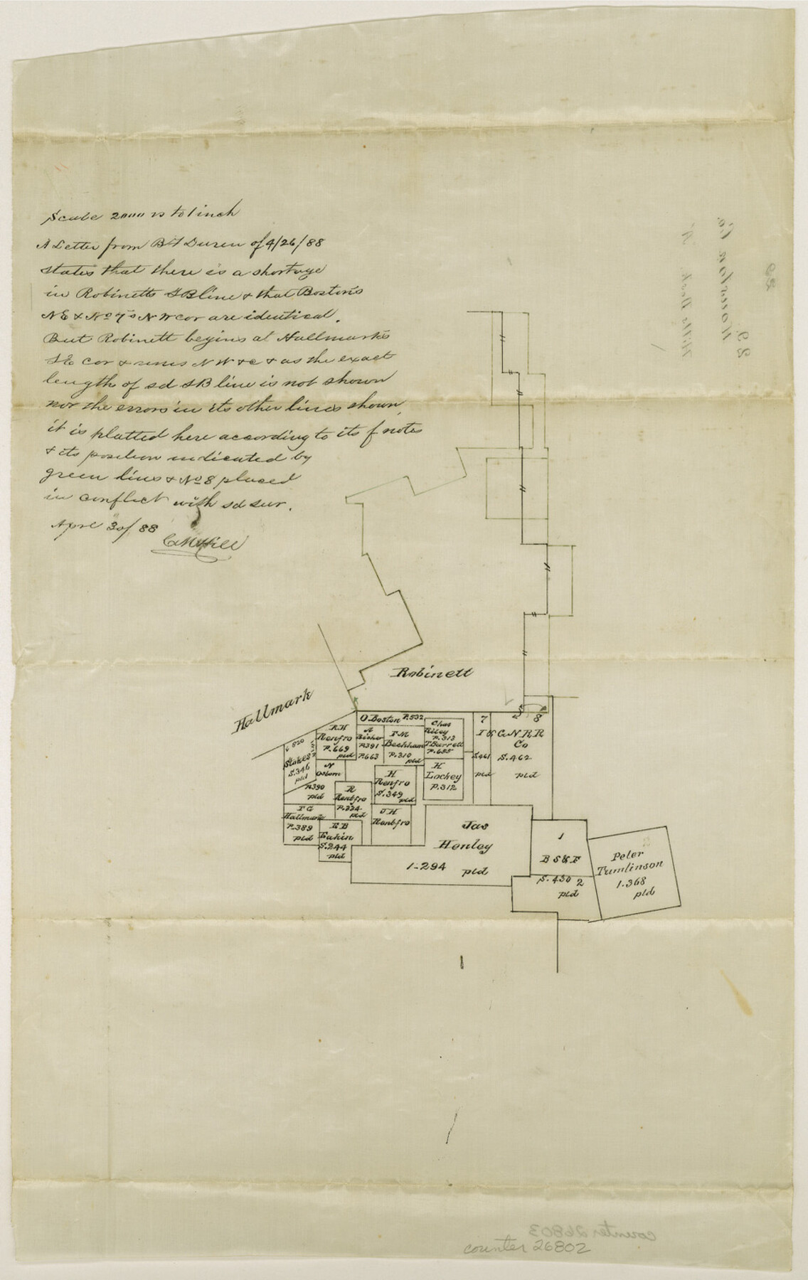
Houston County Sketch File 29
[Two sketches, both around the Peter Tumlinson survey]
-
Map/Doc
26802
-
Collection
General Map Collection
-
Object Dates
8/19/1859 (Creation Date)
-
People and Organizations
Stremme (Surveyor/Engineer)
-
Counties
Houston
-
Subjects
Surveying Sketch File
-
Height x Width
15.0 x 9.4 inches
38.1 x 23.9 cm
-
Medium
paper, manuscript
-
Scale
1:2000
-
Features
Putty Creek
Part of: General Map Collection
Crockett County Working Sketch 49

Print $20.00
- Digital $50.00
Crockett County Working Sketch 49
1938
Size 46.7 x 43.9 inches
Map/Doc 68382
Reeves County Working Sketch 16

Print $40.00
- Digital $50.00
Reeves County Working Sketch 16
1961
Size 30.8 x 48.8 inches
Map/Doc 63459
Bexar County Sketch File 41

Print $4.00
- Digital $50.00
Bexar County Sketch File 41
Size 8.3 x 5.3 inches
Map/Doc 14516
Hutchinson County Rolled Sketch 15

Print $47.00
- Digital $50.00
Hutchinson County Rolled Sketch 15
1911
Size 28.9 x 27.0 inches
Map/Doc 10201
Red River Co.

Print $40.00
- Digital $50.00
Red River Co.
1897
Size 48.0 x 39.4 inches
Map/Doc 66993
Hunt County Boundary File 5

Print $6.00
- Digital $50.00
Hunt County Boundary File 5
Size 11.2 x 8.9 inches
Map/Doc 55222
El Paso County Sketch File 22

Print $22.00
- Digital $50.00
El Paso County Sketch File 22
1888
Size 14.2 x 9.0 inches
Map/Doc 22031
Flight Mission No. DAG-28K, Frame 28, Matagorda County

Print $20.00
- Digital $50.00
Flight Mission No. DAG-28K, Frame 28, Matagorda County
1953
Size 18.5 x 22.5 inches
Map/Doc 86596
San Jacinto River and Tributaries, Texas - Survey of 1939

Print $20.00
- Digital $50.00
San Jacinto River and Tributaries, Texas - Survey of 1939
1939
Size 27.8 x 40.7 inches
Map/Doc 60308
Irion County Sketch File 10

Print $20.00
- Digital $50.00
Irion County Sketch File 10
1936
Size 16.7 x 30.5 inches
Map/Doc 11825
[Surveys in the Jasper District]
![69734, [Surveys in the Jasper District], General Map Collection](https://historictexasmaps.com/wmedia_w700/maps/69734.tif.jpg)
Print $2.00
- Digital $50.00
[Surveys in the Jasper District]
1847
Size 9.4 x 6.9 inches
Map/Doc 69734
Upshur County Working Sketch 14

Print $20.00
- Digital $50.00
Upshur County Working Sketch 14
1993
Size 23.1 x 37.1 inches
Map/Doc 69571
You may also like
Map of Concho County

Print $20.00
- Digital $50.00
Map of Concho County
1879
Size 23.4 x 18.3 inches
Map/Doc 4523
Flight Mission No. DQO-2K, Frame 99, Galveston County

Print $20.00
- Digital $50.00
Flight Mission No. DQO-2K, Frame 99, Galveston County
1952
Size 18.8 x 22.5 inches
Map/Doc 85026
Van Zandt County Sketch File 44

Print $4.00
- Digital $50.00
Van Zandt County Sketch File 44
1858
Size 10.1 x 8.1 inches
Map/Doc 39499
[T. & P. Blocks 31-36, Townships 1N-5N]
![93054, [T. & P. Blocks 31-36, Townships 1N-5N], Twichell Survey Records](https://historictexasmaps.com/wmedia_w700/maps/93054-1.tif.jpg)
Print $20.00
- Digital $50.00
[T. & P. Blocks 31-36, Townships 1N-5N]
Size 14.2 x 17.4 inches
Map/Doc 93054
Cass County Rolled Sketch OPD

Print $20.00
- Digital $50.00
Cass County Rolled Sketch OPD
1936
Size 29.4 x 25.1 inches
Map/Doc 5483
Gulf Coast of the United States, Key West to Rio Grande

Print $20.00
- Digital $50.00
Gulf Coast of the United States, Key West to Rio Grande
1892
Size 27.3 x 18.3 inches
Map/Doc 72671
Jeff Davis Co.

Print $40.00
- Digital $50.00
Jeff Davis Co.
1915
Size 30.4 x 52.2 inches
Map/Doc 66881
Midland County Working Sketch 32

Print $40.00
- Digital $50.00
Midland County Working Sketch 32
1971
Size 51.3 x 35.5 inches
Map/Doc 71013
Pecos County Working Sketch 125

Print $40.00
- Digital $50.00
Pecos County Working Sketch 125
1974
Size 53.4 x 37.0 inches
Map/Doc 71598
Sabine Pass and Lake

Print $20.00
- Digital $50.00
Sabine Pass and Lake
1975
Size 46.9 x 27.8 inches
Map/Doc 69827
Terry County Sketch File 10

Print $20.00
- Digital $50.00
Terry County Sketch File 10
Size 10.8 x 43.2 inches
Map/Doc 10394
Briscoe County Sketch File O-1

Print $2.00
- Digital $50.00
Briscoe County Sketch File O-1
1935
Size 11.3 x 7.2 inches
Map/Doc 16425