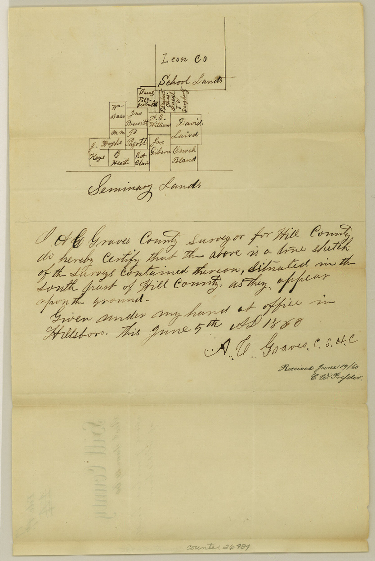
Hill County Sketch File 17
[Sketch south of Hillsboro near Leon County School Land]
-
Map/Doc
26484
-
Collection
General Map Collection
-
Object Dates
6/5/1860 (Creation Date)
6/19/1860 (File Date)
-
People and Organizations
A.C. Graves (Surveyor/Engineer)
-
Counties
Hill
-
Subjects
Surveying Sketch File
-
Height x Width
12.5 x 8.3 inches
31.8 x 21.1 cm
-
Medium
paper, manuscript
Part of: General Map Collection
Right of Way and Track Map International & Gt. Northern Ry. operated by the International & Gt. Northern Ry. Co., Columbia Branch, Gulf Division

Print $40.00
- Digital $50.00
Right of Way and Track Map International & Gt. Northern Ry. operated by the International & Gt. Northern Ry. Co., Columbia Branch, Gulf Division
1917
Size 25.1 x 56.7 inches
Map/Doc 64597
Culberson County Sketch File 16

Print $20.00
- Digital $50.00
Culberson County Sketch File 16
Size 27.0 x 38.1 inches
Map/Doc 11268
Red River County Working Sketch 31

Print $20.00
- Digital $50.00
Red River County Working Sketch 31
1962
Size 30.9 x 31.3 inches
Map/Doc 72014
Mapa de los Estados Unidos Mejicanos arreglado a la distribucion que en diversos decretos ha hecho del territorio el Congreso General Mejicano

Print $20.00
- Digital $50.00
Mapa de los Estados Unidos Mejicanos arreglado a la distribucion que en diversos decretos ha hecho del territorio el Congreso General Mejicano
Size 24.6 x 30.3 inches
Map/Doc 96514
Goliad County Working Sketch 3

Print $40.00
- Digital $50.00
Goliad County Working Sketch 3
1916
Size 42.8 x 76.4 inches
Map/Doc 63193
Flight Mission No. BRA-16M, Frame 142, Jefferson County

Print $20.00
- Digital $50.00
Flight Mission No. BRA-16M, Frame 142, Jefferson County
1953
Size 18.5 x 22.2 inches
Map/Doc 85748
Amistad International Reservoir on Rio Grande 74

Print $20.00
- Digital $50.00
Amistad International Reservoir on Rio Grande 74
1949
Size 28.5 x 40.2 inches
Map/Doc 75501
Fannin County

Print $20.00
- Digital $50.00
Fannin County
1946
Size 42.3 x 37.4 inches
Map/Doc 73145
Reagan County Rolled Sketch 12

Print $20.00
- Digital $50.00
Reagan County Rolled Sketch 12
1940
Size 25.9 x 27.0 inches
Map/Doc 7440
Map of the District of San Patricio and Nueces

Print $40.00
- Digital $50.00
Map of the District of San Patricio and Nueces
Size 93.8 x 38.4 inches
Map/Doc 93366
Dickens County Boundary File 1

Print $6.00
- Digital $50.00
Dickens County Boundary File 1
Size 8.8 x 3.7 inches
Map/Doc 52530
Hunt County Working Sketch 8

Print $20.00
- Digital $50.00
Hunt County Working Sketch 8
1958
Size 24.5 x 24.4 inches
Map/Doc 66355
You may also like
Fannin County Boundary File 1a

Print $40.00
- Digital $50.00
Fannin County Boundary File 1a
1882
Size 36.5 x 9.5 inches
Map/Doc 53279
Flight Mission No. DCL-7C, Frame 12, Kenedy County

Print $20.00
- Digital $50.00
Flight Mission No. DCL-7C, Frame 12, Kenedy County
1943
Size 15.4 x 15.3 inches
Map/Doc 86004
Marion County Working Sketch 3

Print $20.00
- Digital $50.00
Marion County Working Sketch 3
Size 34.9 x 30.0 inches
Map/Doc 70778
[Map showing T&P Lands in El Paso County]
![88931, [Map showing T&P Lands in El Paso County], Library of Congress](https://historictexasmaps.com/wmedia_w700/maps/88931.tif.jpg)
Print $20.00
[Map showing T&P Lands in El Paso County]
Size 22.4 x 17.3 inches
Map/Doc 88931
Wichita County Working Sketch 24

Print $20.00
- Digital $50.00
Wichita County Working Sketch 24
1971
Size 21.2 x 16.2 inches
Map/Doc 72534
Floyd County Working Sketch 2

Print $20.00
- Digital $50.00
Floyd County Working Sketch 2
1911
Size 41.0 x 24.8 inches
Map/Doc 69181
[West Part of Labor 18]
![91006, [West Part of Labor 18], Twichell Survey Records](https://historictexasmaps.com/wmedia_w700/maps/91006-1.tif.jpg)
Print $20.00
- Digital $50.00
[West Part of Labor 18]
Size 18.9 x 19.4 inches
Map/Doc 91006
Gaines County Rolled Sketch G3A

Print $20.00
- Digital $50.00
Gaines County Rolled Sketch G3A
1902
Size 22.5 x 31.1 inches
Map/Doc 5947
Hudspeth County Sketch File 33

Print $6.00
- Digital $50.00
Hudspeth County Sketch File 33
1952
Size 11.3 x 8.8 inches
Map/Doc 26994
Parker County Rolled Sketch 1

Print $20.00
- Digital $50.00
Parker County Rolled Sketch 1
1878
Size 19.8 x 24.6 inches
Map/Doc 7202
Nolan County Working Sketch 3

Print $20.00
- Digital $50.00
Nolan County Working Sketch 3
1947
Size 23.5 x 17.2 inches
Map/Doc 71294
[Right of Way & Track Map, The Texas & Pacific Ry. Co. Main Line]
![64660, [Right of Way & Track Map, The Texas & Pacific Ry. Co. Main Line], General Map Collection](https://historictexasmaps.com/wmedia_w700/maps/64660.tif.jpg)
Print $20.00
- Digital $50.00
[Right of Way & Track Map, The Texas & Pacific Ry. Co. Main Line]
Size 11.0 x 18.6 inches
Map/Doc 64660