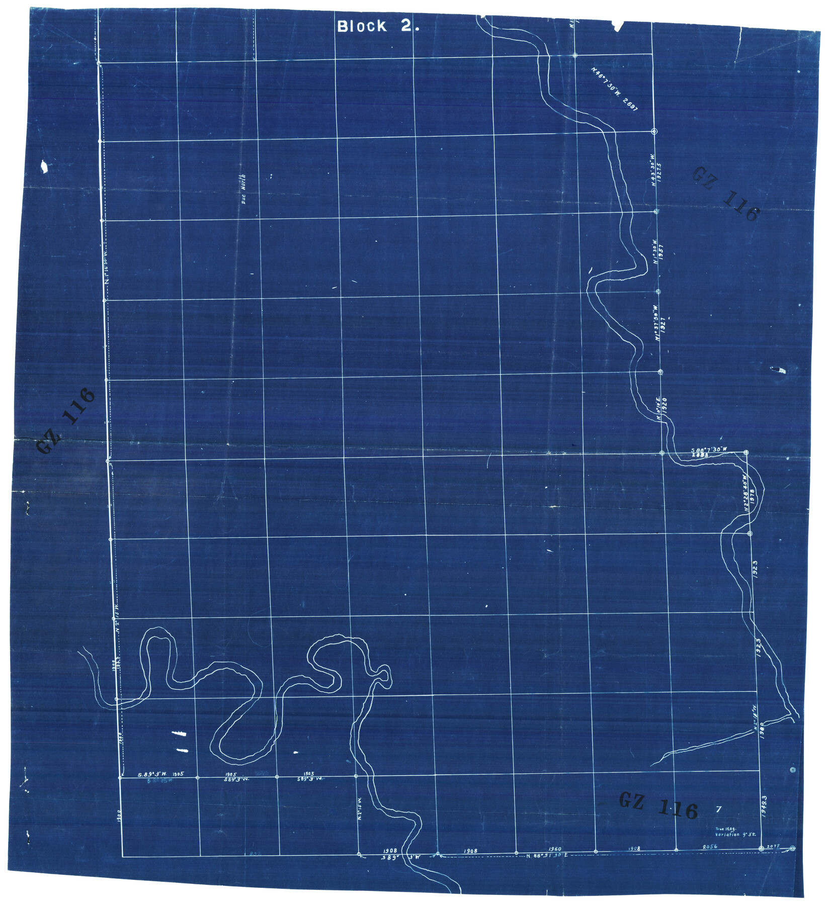
Block 2
GZ116
-
Map/Doc
93224
-
Collection
Twichell Survey Records
-
Counties
Garza
-
Height x Width
19.5 x 21.5 inches
49.5 x 54.6 cm
Part of: Twichell Survey Records
Yoakum-Terry County Sketch

Print $20.00
- Digital $50.00
Yoakum-Terry County Sketch
Size 9.4 x 27.3 inches
Map/Doc 91977
[Working Sketch Survey 46]
![90955, [Working Sketch Survey 46], Twichell Survey Records](https://historictexasmaps.com/wmedia_w700/maps/90955-1.tif.jpg)
Print $20.00
- Digital $50.00
[Working Sketch Survey 46]
Size 19.0 x 11.8 inches
Map/Doc 90955
[Sketch showing Blocks B5 and B6 and Capitol Land Reservation]
![89973, [Sketch showing Blocks B5 and B6 and Capitol Land Reservation], Twichell Survey Records](https://historictexasmaps.com/wmedia_w700/maps/89973-1.tif.jpg)
Print $20.00
- Digital $50.00
[Sketch showing Blocks B5 and B6 and Capitol Land Reservation]
Size 46.3 x 41.9 inches
Map/Doc 89973
Subdivision of the C.C. Slaughter Block No. 1, League 101 & part of League 102, Jeff Davis Co. School Land, part of League 100, Brewster Co. School Land and League 118 & part of Leagues 117 & 119, Knox Co. School Land

Print $20.00
- Digital $50.00
Subdivision of the C.C. Slaughter Block No. 1, League 101 & part of League 102, Jeff Davis Co. School Land, part of League 100, Brewster Co. School Land and League 118 & part of Leagues 117 & 119, Knox Co. School Land
1926
Size 18.8 x 19.4 inches
Map/Doc 90459
Gaines County Sketch

Print $3.00
- Digital $50.00
Gaines County Sketch
Size 9.7 x 16.1 inches
Map/Doc 92948
R. L. Gladney 160 acres in northwest 48, Block 9

Print $20.00
- Digital $50.00
R. L. Gladney 160 acres in northwest 48, Block 9
Size 15.9 x 30.8 inches
Map/Doc 91731
[H. & T. C. Block 47 and vicinity]
![91171, [H. & T. C. Block 47 and vicinity], Twichell Survey Records](https://historictexasmaps.com/wmedia_w700/maps/91171-1.tif.jpg)
Print $20.00
- Digital $50.00
[H. & T. C. Block 47 and vicinity]
1891
Size 19.4 x 15.3 inches
Map/Doc 91171
Map No. 1 - Surveys Located in 1881 as they appear on the ground

Print $20.00
- Digital $50.00
Map No. 1 - Surveys Located in 1881 as they appear on the ground
Size 29.6 x 18.8 inches
Map/Doc 91889
[G. C. & S. F. Railroad Company, Block S]
![91330, [G. C. & S. F. Railroad Company, Block S], Twichell Survey Records](https://historictexasmaps.com/wmedia_w700/maps/91330-1.tif.jpg)
Print $2.00
- Digital $50.00
[G. C. & S. F. Railroad Company, Block S]
Size 8.6 x 6.0 inches
Map/Doc 91330
[Sketch fragment in Garza and Crosby Counties]
![90855, [Sketch fragment in Garza and Crosby Counties], Twichell Survey Records](https://historictexasmaps.com/wmedia_w700/maps/90855-2.tif.jpg)
Print $20.00
- Digital $50.00
[Sketch fragment in Garza and Crosby Counties]
Size 32.6 x 17.0 inches
Map/Doc 90855
[Blocks 34-36, Township 1N]
![92032, [Blocks 34-36, Township 1N], Twichell Survey Records](https://historictexasmaps.com/wmedia_w700/maps/92032-1.tif.jpg)
Print $20.00
- Digital $50.00
[Blocks 34-36, Township 1N]
Size 37.0 x 24.0 inches
Map/Doc 92032
[Southwest corner Runnels County School Land League 3 and vicinity]
![93115, [Southwest corner Runnels County School Land League 3 and vicinity], Twichell Survey Records](https://historictexasmaps.com/wmedia_w700/maps/93115-1.tif.jpg)
Print $20.00
- Digital $50.00
[Southwest corner Runnels County School Land League 3 and vicinity]
Size 42.6 x 32.0 inches
Map/Doc 93115
You may also like
Baseline Parcels 83 - Superconducting Super Collider

Print $20.00
- Digital $50.00
Baseline Parcels 83 - Superconducting Super Collider
1991
Size 31.0 x 39.2 inches
Map/Doc 93676
The City of Austin and Suburbs

Print $20.00
The City of Austin and Suburbs
1919
Size 24.1 x 19.1 inches
Map/Doc 76203
Flight Mission No. DQN-6K, Frame 73, Calhoun County

Print $20.00
- Digital $50.00
Flight Mission No. DQN-6K, Frame 73, Calhoun County
1953
Size 18.5 x 22.1 inches
Map/Doc 84445
Zapata County Rolled Sketch 20

Print $40.00
- Digital $50.00
Zapata County Rolled Sketch 20
1956
Size 21.2 x 49.1 inches
Map/Doc 10171
Map of Pecos and Reeves Counties

Print $40.00
- Digital $50.00
Map of Pecos and Reeves Counties
1873
Size 45.3 x 115.6 inches
Map/Doc 75930
Flight Mission No. BRA-7M, Frame 37, Jefferson County

Print $20.00
- Digital $50.00
Flight Mission No. BRA-7M, Frame 37, Jefferson County
1953
Size 18.7 x 22.4 inches
Map/Doc 85488
General Highway Map of Gaines County, Texas

Print $20.00
- Digital $50.00
General Highway Map of Gaines County, Texas
1951
Size 19.0 x 26.2 inches
Map/Doc 92644
South Part of Brewster Co.

Print $40.00
- Digital $50.00
South Part of Brewster Co.
1955
Size 48.2 x 40.5 inches
Map/Doc 73089
[Galveston, Harrisburg & San Antonio Railroad from Cuero to Stockdale]
![64185, [Galveston, Harrisburg & San Antonio Railroad from Cuero to Stockdale], General Map Collection](https://historictexasmaps.com/wmedia_w700/maps/64185.tif.jpg)
Print $20.00
- Digital $50.00
[Galveston, Harrisburg & San Antonio Railroad from Cuero to Stockdale]
1906
Size 13.6 x 34.0 inches
Map/Doc 64185
Ector County Working Sketch 18

Print $20.00
- Digital $50.00
Ector County Working Sketch 18
1957
Size 42.0 x 39.1 inches
Map/Doc 68861
Flight Mission No. CUG-3P, Frame 131, Kleberg County

Print $20.00
- Digital $50.00
Flight Mission No. CUG-3P, Frame 131, Kleberg County
1956
Size 18.7 x 22.4 inches
Map/Doc 86266
The Chief Justice County of Brazoria. Lands in Conflict with Colorado, Harrisburg, Matagorda Counties

Print $20.00
The Chief Justice County of Brazoria. Lands in Conflict with Colorado, Harrisburg, Matagorda Counties
2020
Size 14.8 x 21.7 inches
Map/Doc 96043