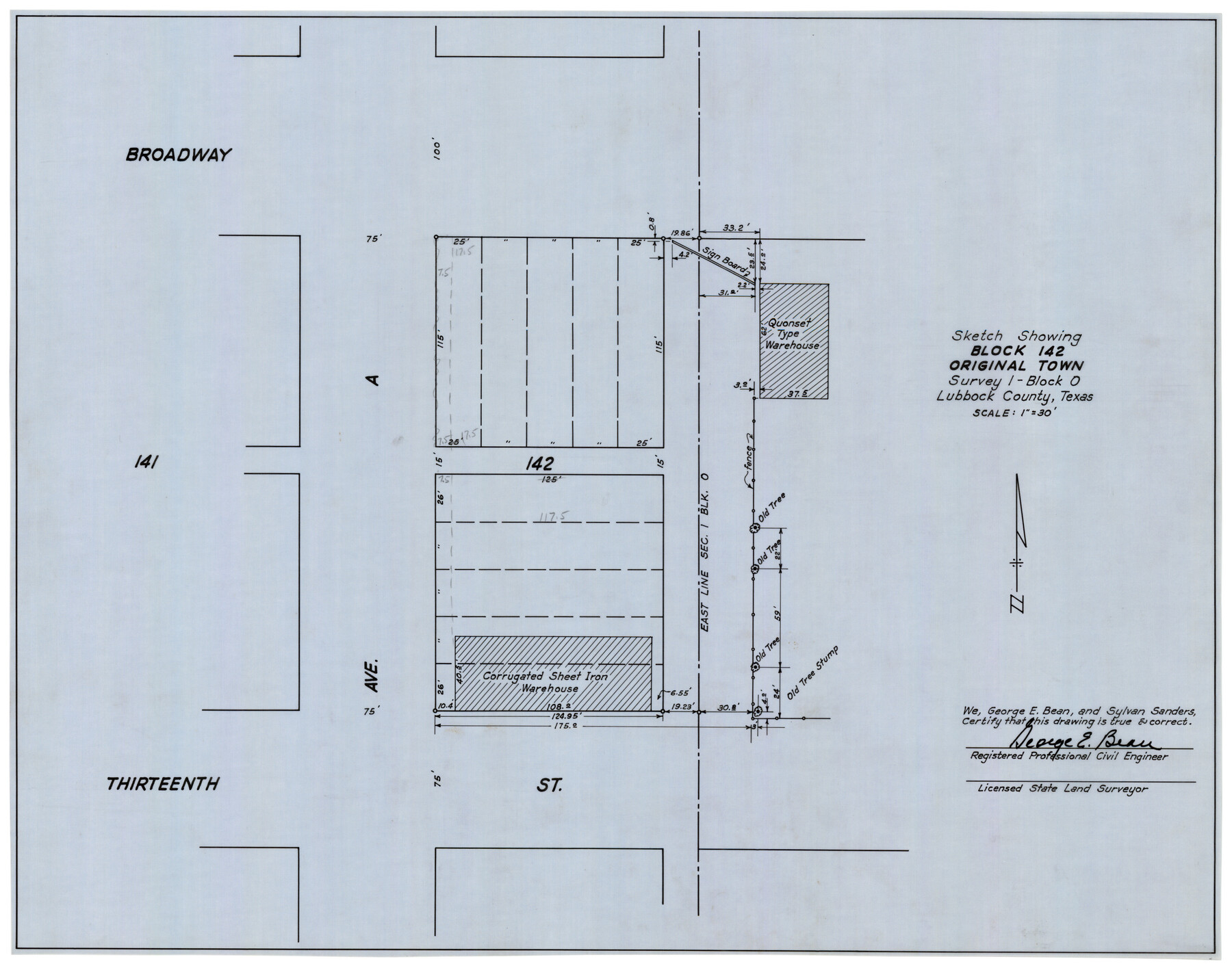
Sketch Showing Block 142, Original Town, Survey 1, Block O
-
Map/Doc
92782
-
Collection
Twichell Survey Records
-
People and Organizations
Sylvan Sanders (Surveyor/Engineer)
-
Counties
Lubbock
-
Height x Width
23.0 x 18.0 inches
58.4 x 45.7 cm
Part of: Twichell Survey Records
George M. Slaughter Block Hockley and Cochran Counties, Texas

Print $20.00
- Digital $50.00
George M. Slaughter Block Hockley and Cochran Counties, Texas
1929
Size 14.1 x 25.2 inches
Map/Doc 92238
Map Showing Lands Surveyed by Sylvan Sanders, Block D

Print $20.00
- Digital $50.00
Map Showing Lands Surveyed by Sylvan Sanders, Block D
Size 28.2 x 23.5 inches
Map/Doc 92440
[Warren Additions 3 and 4 and vicinity]
![92464, [Warren Additions 3 and 4 and vicinity], Twichell Survey Records](https://historictexasmaps.com/wmedia_w700/maps/92464-1.tif.jpg)
Print $20.00
- Digital $50.00
[Warren Additions 3 and 4 and vicinity]
Size 23.9 x 19.5 inches
Map/Doc 92464
Brazos River Conservation and Reclamation District Official Boundary Line Survey

Print $20.00
- Digital $50.00
Brazos River Conservation and Reclamation District Official Boundary Line Survey
Size 37.3 x 24.7 inches
Map/Doc 90129
[Block G, Jonathan Burleson Survey, and vicinity]
![91042, [Block G, Jonathan Burleson Survey, and vicinity], Twichell Survey Records](https://historictexasmaps.com/wmedia_w700/maps/91042-1.tif.jpg)
Print $20.00
- Digital $50.00
[Block G, Jonathan Burleson Survey, and vicinity]
Size 26.4 x 14.6 inches
Map/Doc 91042
J. R. Jameson Farm

Print $3.00
- Digital $50.00
J. R. Jameson Farm
Size 10.8 x 13.5 inches
Map/Doc 92313
Subdivision Map, Calhoun County School Land Leagues 1-4, Located in Hale and Floyd Counties

Print $20.00
- Digital $50.00
Subdivision Map, Calhoun County School Land Leagues 1-4, Located in Hale and Floyd Counties
Size 28.1 x 31.5 inches
Map/Doc 92660
[Tie line from Northeast Block 36, Township 5N to Northwest corner Block M]
![90559, [Tie line from Northeast Block 36, Township 5N to Northwest corner Block M], Twichell Survey Records](https://historictexasmaps.com/wmedia_w700/maps/90559-1.tif.jpg)
Print $20.00
- Digital $50.00
[Tie line from Northeast Block 36, Township 5N to Northwest corner Block M]
Size 22.3 x 10.3 inches
Map/Doc 90559
[Leagues 391, 391 1/2 and part of Block K7]
![90534, [Leagues 391, 391 1/2 and part of Block K7], Twichell Survey Records](https://historictexasmaps.com/wmedia_w700/maps/90534-1.tif.jpg)
Print $2.00
- Digital $50.00
[Leagues 391, 391 1/2 and part of Block K7]
1902
Size 4.7 x 6.3 inches
Map/Doc 90534
[Various County School Land Leagues]
![89849, [Various County School Land Leagues], Twichell Survey Records](https://historictexasmaps.com/wmedia_w700/maps/89849-1.tif.jpg)
Print $40.00
- Digital $50.00
[Various County School Land Leagues]
Size 55.7 x 41.4 inches
Map/Doc 89849
![90591, [Block K7], Twichell Survey Records](https://historictexasmaps.com/wmedia_w700/maps/90591-1.tif.jpg)
[T.& P.R.R.Co., Block 1]
![92963, [T.& P.R.R.Co., Block 1], Twichell Survey Records](https://historictexasmaps.com/wmedia_w700/maps/92963-1.tif.jpg)
Print $20.00
- Digital $50.00
[T.& P.R.R.Co., Block 1]
Size 37.5 x 31.6 inches
Map/Doc 92963
You may also like
Titus County Working Sketch Graphic Index

Print $20.00
- Digital $50.00
Titus County Working Sketch Graphic Index
1948
Size 40.2 x 29.0 inches
Map/Doc 76714
Map of Lipscomb County

Print $20.00
- Digital $50.00
Map of Lipscomb County
1899
Size 43.9 x 38.9 inches
Map/Doc 78406
Duval County Rolled Sketch 22

Print $20.00
- Digital $50.00
Duval County Rolled Sketch 22
1942
Size 19.5 x 30.0 inches
Map/Doc 5741
Briscoe County Working Sketch 3

Print $20.00
- Digital $50.00
Briscoe County Working Sketch 3
1916
Size 28.1 x 22.0 inches
Map/Doc 67806
Map of Mexico, including Yucatan & Upper California, exhibiting the chief cities and towns, the principal travelling routes &c.

Print $20.00
- Digital $50.00
Map of Mexico, including Yucatan & Upper California, exhibiting the chief cities and towns, the principal travelling routes &c.
1846
Size 18.3 x 26.1 inches
Map/Doc 93871
Jeff Davis County Working Sketch 21

Print $20.00
- Digital $50.00
Jeff Davis County Working Sketch 21
1957
Size 25.2 x 44.0 inches
Map/Doc 66516
Flight Mission No. DIX-10P, Frame 69, Aransas County

Print $20.00
- Digital $50.00
Flight Mission No. DIX-10P, Frame 69, Aransas County
1956
Size 18.8 x 22.4 inches
Map/Doc 83930
Sketch in Crockett County [UT Blk. 31, 32, 46, 51, Blks. UV, ST, QR, MN]
![89677, Sketch in Crockett County [UT Blk. 31, 32, 46, 51, Blks. UV, ST, QR, MN], Twichell Survey Records](https://historictexasmaps.com/wmedia_w700/maps/89677-1.tif.jpg)
Print $40.00
- Digital $50.00
Sketch in Crockett County [UT Blk. 31, 32, 46, 51, Blks. UV, ST, QR, MN]
1913
Size 33.7 x 48.0 inches
Map/Doc 89677
Property of Hobbs Trailers Manufacturing Company

Print $20.00
- Digital $50.00
Property of Hobbs Trailers Manufacturing Company
1956
Size 36.6 x 18.9 inches
Map/Doc 92733
Nueces County Working Sketch 4

Print $20.00
- Digital $50.00
Nueces County Working Sketch 4
1951
Size 46.8 x 36.2 inches
Map/Doc 71306
Loving County Working Sketch 7

Print $20.00
- Digital $50.00
Loving County Working Sketch 7
1949
Size 23.4 x 26.3 inches
Map/Doc 70639
Pecos County Working Sketch 42

Print $20.00
- Digital $50.00
Pecos County Working Sketch 42
1942
Size 31.3 x 23.9 inches
Map/Doc 71514