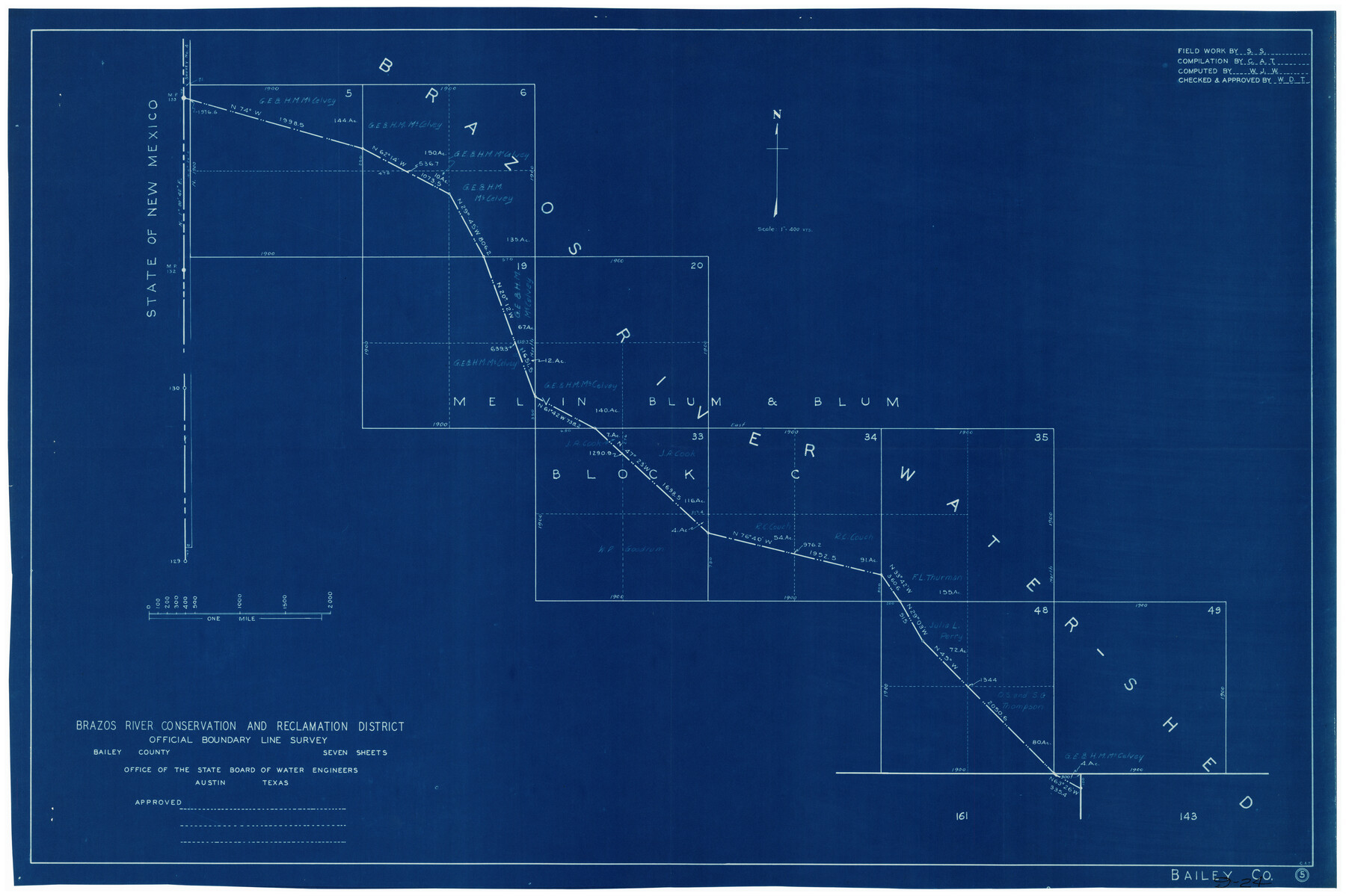
Brazos River Conservation and Reclamation District Official Boundary Line Survey
9-24
-
Map/Doc
90129
-
Collection
Twichell Survey Records
-
People and Organizations
Office of the State Board of Water Engineers (Publisher)
Sylvan Sanders (Surveyor/Engineer)
-
Counties
Bailey
-
Height x Width
37.3 x 24.7 inches
94.7 x 62.7 cm
Part of: Twichell Survey Records
Map of North-Western Texas (Pan Handle)

Print $20.00
- Digital $50.00
Map of North-Western Texas (Pan Handle)
Size 17.2 x 21.4 inches
Map/Doc 91804
[Mrs. May Vinson Survey]
![91959, [Mrs. May Vinson Survey], Twichell Survey Records](https://historictexasmaps.com/wmedia_w700/maps/91959-1.tif.jpg)
Print $40.00
- Digital $50.00
[Mrs. May Vinson Survey]
Size 48.4 x 21.9 inches
Map/Doc 91959
[T. & P. Block 44, Township 1S]
![90818, [T. & P. Block 44, Township 1S], Twichell Survey Records](https://historictexasmaps.com/wmedia_w700/maps/90818-2.tif.jpg)
Print $3.00
- Digital $50.00
[T. & P. Block 44, Township 1S]
Size 9.3 x 11.9 inches
Map/Doc 90818
[H. & T. C. Blocks 47 1/2 and 48, Capitol Lands]
![90639, [H. & T. C. Blocks 47 1/2 and 48, Capitol Lands], Twichell Survey Records](https://historictexasmaps.com/wmedia_w700/maps/90639-1.tif.jpg)
Print $20.00
- Digital $50.00
[H. & T. C. Blocks 47 1/2 and 48, Capitol Lands]
Size 19.9 x 24.8 inches
Map/Doc 90639
[Sketch Between Hemphill County and Oklahoma]
![89670, [Sketch Between Hemphill County and Oklahoma], Twichell Survey Records](https://historictexasmaps.com/wmedia_w700/maps/89670-1.tif.jpg)
Print $40.00
- Digital $50.00
[Sketch Between Hemphill County and Oklahoma]
Size 60.4 x 7.8 inches
Map/Doc 89670
[Sketch focusing on surveys just north of Blocks 31 and 32, Township 6N]
![92996, [Sketch focusing on surveys just north of Blocks 31 and 32, Township 6N], Twichell Survey Records](https://historictexasmaps.com/wmedia_w700/maps/92996-1.tif.jpg)
Print $20.00
- Digital $50.00
[Sketch focusing on surveys just north of Blocks 31 and 32, Township 6N]
Size 24.0 x 12.0 inches
Map/Doc 92996
[Southern Pacific Rail Road Co. Blocks 15 and 16 in Mitchell, Sterling and Coke Counties]
![91839, [Southern Pacific Rail Road Co. Blocks 15 and 16 in Mitchell, Sterling and Coke Counties], Twichell Survey Records](https://historictexasmaps.com/wmedia_w700/maps/91839-1.tif.jpg)
Print $20.00
- Digital $50.00
[Southern Pacific Rail Road Co. Blocks 15 and 16 in Mitchell, Sterling and Coke Counties]
Size 30.5 x 35.7 inches
Map/Doc 91839
[Kent County Block 4, Sections 33 and 46, Block 97, Sections 771 and 772]
![92192, [Kent County Block 4, Sections 33 and 46, Block 97, Sections 771 and 772], Twichell Survey Records](https://historictexasmaps.com/wmedia_w700/maps/92192-1.tif.jpg)
Print $2.00
- Digital $50.00
[Kent County Block 4, Sections 33 and 46, Block 97, Sections 771 and 772]
1951
Size 8.7 x 15.6 inches
Map/Doc 92192

[Blocks M13, S1, C3, JK3, and JK]
![90700, [Blocks M13, S1, C3, JK3, and JK], Twichell Survey Records](https://historictexasmaps.com/wmedia_w700/maps/90700-1.tif.jpg)
Print $20.00
- Digital $50.00
[Blocks M13, S1, C3, JK3, and JK]
Size 26.9 x 15.4 inches
Map/Doc 90700
Map of Re-Survey of Blk. 34 & 35 T5N

Print $40.00
- Digital $50.00
Map of Re-Survey of Blk. 34 & 35 T5N
1915
Size 53.5 x 39.2 inches
Map/Doc 89765
[Sketch showing the Northwest part of Hale County and the Northeast part of Lamb County]
![93204, [Sketch showing the Northwest part of Hale County and the Northeast part of Lamb County], Twichell Survey Records](https://historictexasmaps.com/wmedia_w700/maps/93204-1.tif.jpg)
Print $40.00
- Digital $50.00
[Sketch showing the Northwest part of Hale County and the Northeast part of Lamb County]
Size 55.1 x 57.3 inches
Map/Doc 93204
You may also like

Edwards County Sketch File 5

Print $5.00
- Digital $50.00
Edwards County Sketch File 5
Size 9.0 x 3.9 inches
Map/Doc 21682
Flight Mission No. DQN-6K, Frame 12, Calhoun County

Print $20.00
- Digital $50.00
Flight Mission No. DQN-6K, Frame 12, Calhoun County
1953
Size 18.6 x 22.2 inches
Map/Doc 84434
Edwards County Rolled Sketch 32

Print $20.00
- Digital $50.00
Edwards County Rolled Sketch 32
1986
Size 36.7 x 24.3 inches
Map/Doc 8850
Presidio County Rolled Sketch 134

Print $20.00
- Digital $50.00
Presidio County Rolled Sketch 134
Size 26.6 x 39.6 inches
Map/Doc 7401
[Missouri, Kansas & Texas Line Map through Bastrop County]
![64028, [Missouri, Kansas & Texas Line Map through Bastrop County], General Map Collection](https://historictexasmaps.com/wmedia_w700/maps/64028.tif.jpg)
Print $40.00
- Digital $50.00
[Missouri, Kansas & Texas Line Map through Bastrop County]
1916
Size 26.2 x 121.8 inches
Map/Doc 64028
[H. & T. C. Block 47, H. & G. N. Block E]
![91259, [H. & T. C. Block 47, H. & G. N. Block E], Twichell Survey Records](https://historictexasmaps.com/wmedia_w700/maps/91259-1.tif.jpg)
Print $20.00
- Digital $50.00
[H. & T. C. Block 47, H. & G. N. Block E]
1874
Size 22.1 x 12.9 inches
Map/Doc 91259
Real County Working Sketch 81

Print $20.00
- Digital $50.00
Real County Working Sketch 81
1984
Size 19.9 x 17.1 inches
Map/Doc 71973
King County Working Sketch 5

Print $20.00
- Digital $50.00
King County Working Sketch 5
1943
Size 19.2 x 22.0 inches
Map/Doc 70169
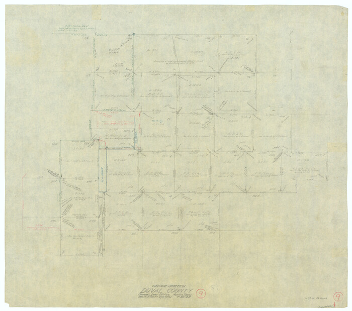
Duval County Working Sketch 9
Print $20.00
- Digital $50.00
Duval County Working Sketch 9
1935
Size 25.8 x 29.1 inches
Map/Doc 68722
Somervell County Rolled Sketch D

Print $20.00
- Digital $50.00
Somervell County Rolled Sketch D
1939
Size 17.3 x 21.0 inches
Map/Doc 7794
[Plat map of Provident City and surrounding] / Map showing the Gulf Coast Country and Railways and Water Shipping Facilities of the Provident Land Tract
![95819, [Plat map of Provident City and surrounding] / Map showing the Gulf Coast Country and Railways and Water Shipping Facilities of the Provident Land Tract, Cobb Digital Map Collection](https://historictexasmaps.com/wmedia_w700/maps/95819.tif.jpg)
Print $20.00
- Digital $50.00
[Plat map of Provident City and surrounding] / Map showing the Gulf Coast Country and Railways and Water Shipping Facilities of the Provident Land Tract
1908
Size 22.0 x 22.9 inches
Map/Doc 95819