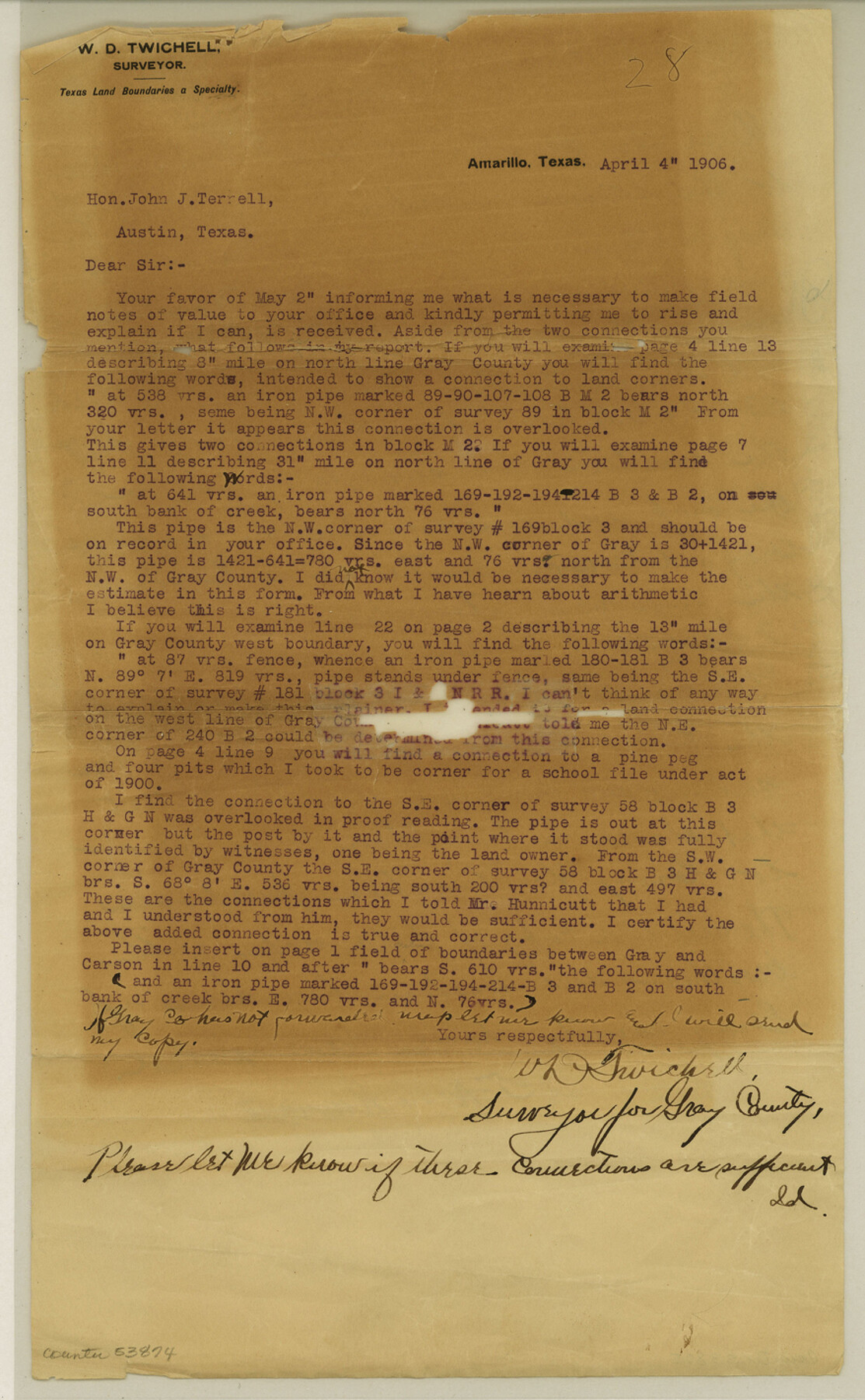
Gray County Boundary File 3a
[Letter regarding North Boundary line of Gray County]
-
Map/Doc
53874
-
Collection
General Map Collection
-
Counties
Gray
-
Subjects
County Boundaries
-
Height x Width
14.2 x 8.8 inches
36.1 x 22.4 cm
Part of: General Map Collection
Pecos County Working Sketch 61

Print $20.00
- Digital $50.00
Pecos County Working Sketch 61
1952
Size 28.4 x 22.7 inches
Map/Doc 71533
Leon River, Leon River Sheet No. 1

Print $4.00
- Digital $50.00
Leon River, Leon River Sheet No. 1
1936
Size 29.2 x 19.8 inches
Map/Doc 65067
Tom Green County Sketch File 41

Print $8.00
- Digital $50.00
Tom Green County Sketch File 41
1884
Size 12.8 x 8.3 inches
Map/Doc 38196
Glasscock County Rolled Sketch 2

Print $20.00
- Digital $50.00
Glasscock County Rolled Sketch 2
1906
Size 19.6 x 14.8 inches
Map/Doc 6013
Orange County Sketch File 41

Print $40.00
- Digital $50.00
Orange County Sketch File 41
1918
Size 13.2 x 13.3 inches
Map/Doc 33381
Wilson County Working Sketch 2

Print $20.00
- Digital $50.00
Wilson County Working Sketch 2
1950
Size 42.0 x 42.8 inches
Map/Doc 72582
Coke County Sketch File 36

Print $24.00
- Digital $50.00
Coke County Sketch File 36
1918
Size 14.1 x 8.5 inches
Map/Doc 18652
Garza County Working Sketch 15

Print $20.00
- Digital $50.00
Garza County Working Sketch 15
1994
Size 32.2 x 26.9 inches
Map/Doc 63162
Brown County Working Sketch 10

Print $20.00
- Digital $50.00
Brown County Working Sketch 10
1982
Size 25.3 x 25.5 inches
Map/Doc 67775
[Sketch for Mineral Application 24072, San Jacinto River]
![65596, [Sketch for Mineral Application 24072, San Jacinto River], General Map Collection](https://historictexasmaps.com/wmedia_w700/maps/65596.tif.jpg)
Print $20.00
- Digital $50.00
[Sketch for Mineral Application 24072, San Jacinto River]
1929
Size 24.5 x 18.5 inches
Map/Doc 65596
Andrews County Rolled Sketch 32

Print $20.00
- Digital $50.00
Andrews County Rolled Sketch 32
1950
Size 26.2 x 16.4 inches
Map/Doc 77176
Flight Mission No. DIX-6P, Frame 110, Aransas County

Print $20.00
- Digital $50.00
Flight Mission No. DIX-6P, Frame 110, Aransas County
1956
Size 19.7 x 23.4 inches
Map/Doc 83816
You may also like
Glasscock County, Texas

Print $20.00
- Digital $50.00
Glasscock County, Texas
1889
Size 21.7 x 18.1 inches
Map/Doc 730
Tech Memorial Park, Inc. Catholic Section

Print $20.00
- Digital $50.00
Tech Memorial Park, Inc. Catholic Section
Size 18.1 x 26.5 inches
Map/Doc 92348
Louisiana and Texas Intracoastal Waterway

Print $20.00
- Digital $50.00
Louisiana and Texas Intracoastal Waterway
1929
Size 13.6 x 19.8 inches
Map/Doc 83345
Schleicher County Sketch File 32

Print $22.00
- Digital $50.00
Schleicher County Sketch File 32
1941
Size 9.1 x 13.3 inches
Map/Doc 36532
Map of Cameron County

Print $20.00
- Digital $50.00
Map of Cameron County
1873
Size 42.2 x 22.5 inches
Map/Doc 3364
Shackelford County, Map of SE part of Block No. 1, Eastern Texas RR. Co. Survey

Print $20.00
- Digital $50.00
Shackelford County, Map of SE part of Block No. 1, Eastern Texas RR. Co. Survey
Size 19.1 x 19.5 inches
Map/Doc 91899
[Galveston, Harrisburg & San Antonio Railroad from Cuero to Stockdale]
![64190, [Galveston, Harrisburg & San Antonio Railroad from Cuero to Stockdale], General Map Collection](https://historictexasmaps.com/wmedia_w700/maps/64190.tif.jpg)
Print $20.00
- Digital $50.00
[Galveston, Harrisburg & San Antonio Railroad from Cuero to Stockdale]
1907
Size 13.7 x 34.0 inches
Map/Doc 64190

[Report showing connections and corners made on ground in south part of Yoakum County and north part of Gaines County, Texas]

[Report showing connections and corners made on ground in south part of Yoakum County and north part of Gaines County, Texas]
1938
Size 8.1 x 10.9 inches
Map/Doc 93256
General Highway Map, Angelina County, Texas

Print $20.00
General Highway Map, Angelina County, Texas
1961
Size 25.1 x 18.1 inches
Map/Doc 79349

Anderson County Working Sketch 19

Print $20.00
- Digital $50.00
Anderson County Working Sketch 19
1951
Size 15.5 x 29.2 inches
Map/Doc 67019