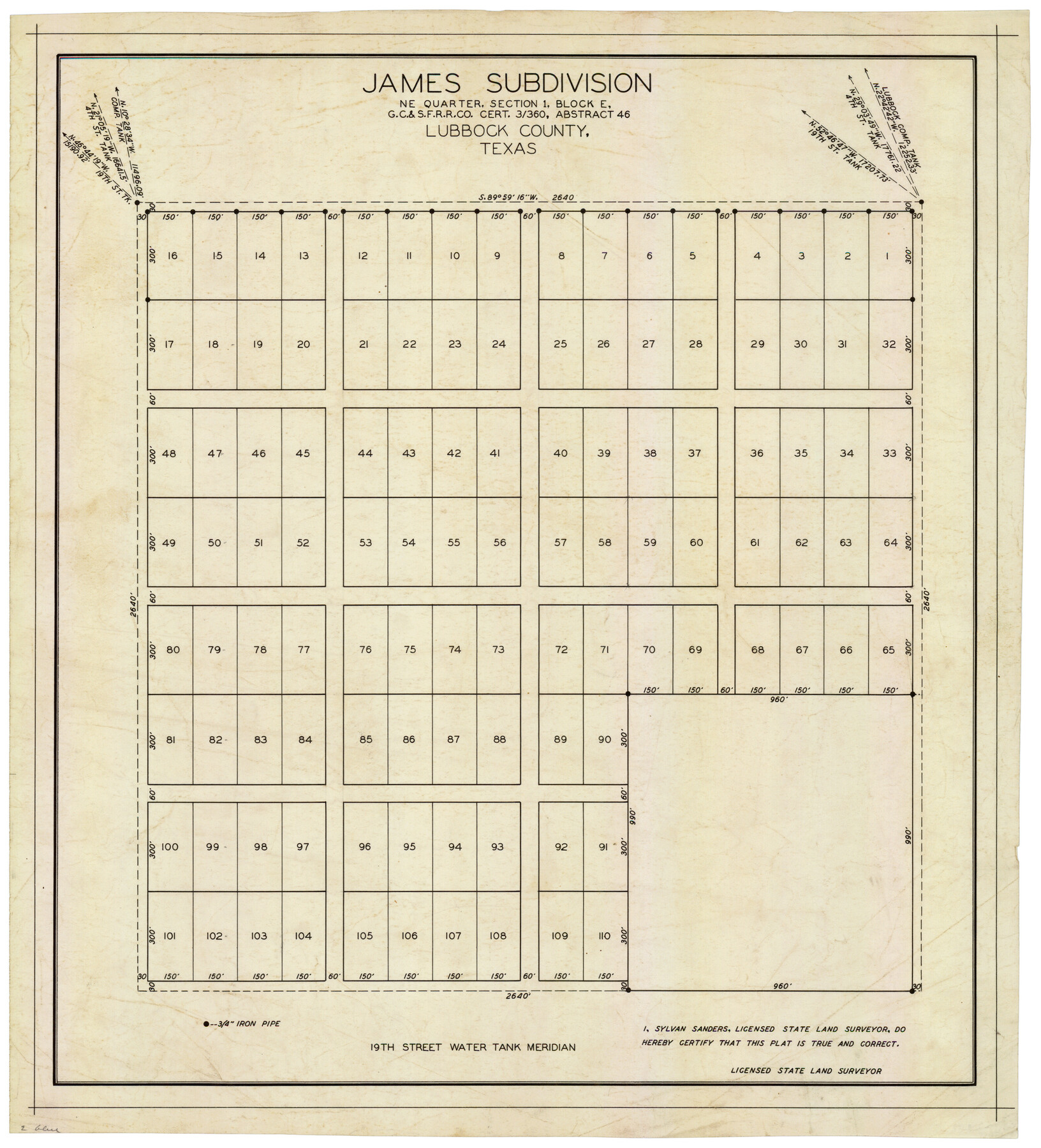
James Subdivision, NE/4 Section 1, Block E, G. C. & S. F. R.R. Co. Cert 3/360, Abstract 46
-
Map/Doc
92734
-
Collection
Twichell Survey Records
-
People and Organizations
Sylvan Sanders (Surveyor/Engineer)
-
Counties
Lubbock
-
Height x Width
17.8 x 19.4 inches
45.2 x 49.3 cm
Part of: Twichell Survey Records
[Guadalupe College]
![91907, [Guadalupe College], Twichell Survey Records](https://historictexasmaps.com/wmedia_w700/maps/91907-1.tif.jpg)
Print $3.00
- Digital $50.00
[Guadalupe College]
Size 16.7 x 9.7 inches
Map/Doc 91907

Portion of Lynn and Terry Counties

Print $20.00
- Digital $50.00
Portion of Lynn and Terry Counties
Size 34.2 x 35.5 inches
Map/Doc 92934
[Worksheets related to the Wilson Strickland survey and vicinity]
![91265, [Vicinity and related to the Wilson Strickland Survey], Twichell Survey Records](https://historictexasmaps.com/wmedia_w700/maps/91265-1.tif.jpg)
Print $20.00
- Digital $50.00
[Worksheets related to the Wilson Strickland survey and vicinity]
Size 39.0 x 11.6 inches
Map/Doc 91265
[Blocks JD, B, D10, A2, A3]
![90777, [Blocks JD, B, D10, A2, A3], Twichell Survey Records](https://historictexasmaps.com/wmedia_w700/maps/90777-1.tif.jpg)
Print $2.00
- Digital $50.00
[Blocks JD, B, D10, A2, A3]
Size 7.3 x 13.4 inches
Map/Doc 90777
[Townships 1 through 5 North, Blocks 34, 35, and 36]
![92587, [Townships 1 through 5 North, Blocks 34, 35, and 36], Twichell Survey Records](https://historictexasmaps.com/wmedia_w700/maps/92587-1.tif.jpg)
Print $20.00
- Digital $50.00
[Townships 1 through 5 North, Blocks 34, 35, and 36]
Size 41.7 x 21.4 inches
Map/Doc 92587
[H. & G. N. Block 1, G. C. & S. F. Block Z]
![91168, [H. & G. N. Block 1, G. C. & S. F. Block Z], Twichell Survey Records](https://historictexasmaps.com/wmedia_w700/maps/91168-1.tif.jpg)
Print $3.00
- Digital $50.00
[H. & G. N. Block 1, G. C. & S. F. Block Z]
Size 16.8 x 10.5 inches
Map/Doc 91168
[East Portion of Lea County] / [Central part of San Miguel County, New Mexico]
![92035, [East Portion of Lea County] / [Central part of San Miguel County, New Mexico], Twichell Survey Records](https://historictexasmaps.com/wmedia_w700/maps/92035-1.tif.jpg)
Print $20.00
- Digital $50.00
[East Portion of Lea County] / [Central part of San Miguel County, New Mexico]
Size 24.9 x 28.9 inches
Map/Doc 92035
Map of XIT Lands, vicinity of Farwell, Texas

Print $20.00
- Digital $50.00
Map of XIT Lands, vicinity of Farwell, Texas
Size 19.6 x 30.8 inches
Map/Doc 91654
Map Showing the Location of Murray Farms

Print $20.00
- Digital $50.00
Map Showing the Location of Murray Farms
Size 13.6 x 17.7 inches
Map/Doc 92832

Map of Public Land on Mustang Island

Print $20.00
- Digital $50.00
Map of Public Land on Mustang Island
1907
Size 17.7 x 22.3 inches
Map/Doc 91492
You may also like
Hamilton Dam, Reservoir Clearing

Print $4.00
- Digital $50.00
Hamilton Dam, Reservoir Clearing
1936
Size 10.5 x 28.9 inches
Map/Doc 2096
Map of the Pitchfork Ranch

Print $20.00
- Digital $50.00
Map of the Pitchfork Ranch
1915
Size 39.9 x 35.9 inches
Map/Doc 75826
Archer County Sketch File 31

Print $8.00
- Digital $50.00
Archer County Sketch File 31
2012
Size 11.0 x 8.5 inches
Map/Doc 93322
Map of Safety First Oil Company Holdings in Runnel County Texas

Print $20.00
- Digital $50.00
Map of Safety First Oil Company Holdings in Runnel County Texas
Size 17.6 x 17.4 inches
Map/Doc 91766
Val Verde County Working Sketch 23

Print $20.00
- Digital $50.00
Val Verde County Working Sketch 23
1932
Size 29.6 x 24.9 inches
Map/Doc 72158

San Jacinto County Rolled Sketch 14

Print $20.00
- Digital $50.00
San Jacinto County Rolled Sketch 14
1998
Size 28.1 x 40.0 inches
Map/Doc 7564
Karnes County Boundary File 2

Print $12.00
- Digital $50.00
Karnes County Boundary File 2
Size 14.1 x 8.7 inches
Map/Doc 55686
Panola County Working Sketch 20

Print $20.00
- Digital $50.00
Panola County Working Sketch 20
1945
Map/Doc 71429
Flight Mission No. CRC-6R, Frame 38, Chambers County

Print $20.00
- Digital $50.00
Flight Mission No. CRC-6R, Frame 38, Chambers County
1956
Size 18.7 x 22.4 inches
Map/Doc 84971
Duval County Sketch File 56

Print $20.00
- Digital $50.00
Duval County Sketch File 56
1938
Size 24.1 x 20.1 inches
Map/Doc 11405
Kleberg County Rolled Sketch 12

Print $20.00
- Digital $50.00
Kleberg County Rolled Sketch 12
1994
Size 25.8 x 36.6 inches
Map/Doc 6553