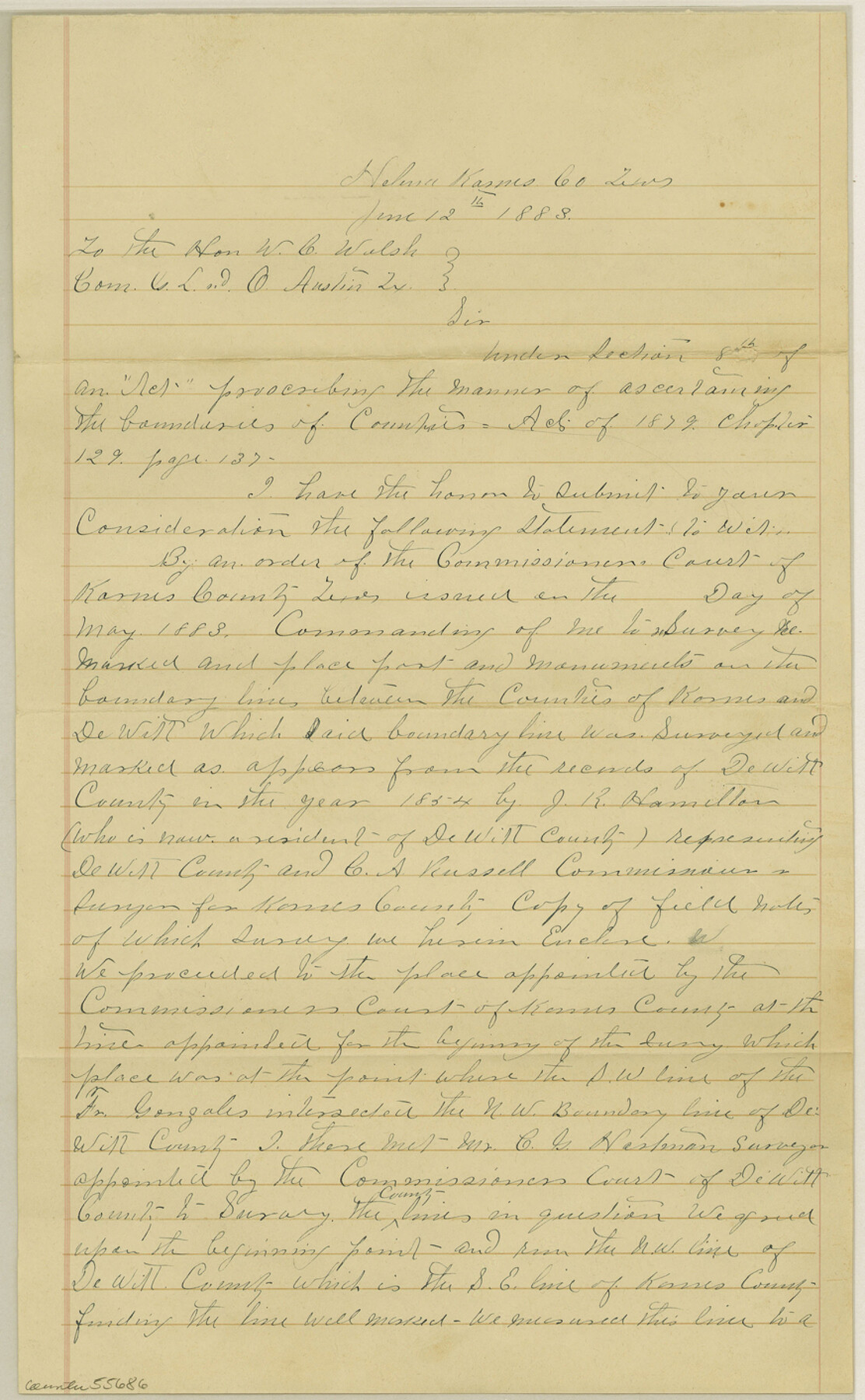
Karnes County Boundary File 2
Copy of field nts. of the Survey made by J. N. Hamilton & C. A. Russell
-
Map/Doc
55686
-
Collection
General Map Collection
-
Counties
Karnes
-
Subjects
County Boundaries
-
Height x Width
14.1 x 8.7 inches
35.8 x 22.1 cm
Part of: General Map Collection
Grayson County Working Sketch 17

Print $20.00
- Digital $50.00
Grayson County Working Sketch 17
1955
Size 16.0 x 42.5 inches
Map/Doc 63256
Flight Mission No. BRA-7M, Frame 17, Jefferson County

Print $20.00
- Digital $50.00
Flight Mission No. BRA-7M, Frame 17, Jefferson County
1953
Size 18.6 x 22.4 inches
Map/Doc 85468
[Drawings of individual counties for Pressler and Langermann's 1879 Map of Texas]
![[Drawings of individual counties for Pressler and Langermann's 1879 Map of Texas]](https://historictexasmaps.com/wmedia_w700/maps/4864.tif.jpg)
Print $20.00
- Digital $50.00
[Drawings of individual counties for Pressler and Langermann's 1879 Map of Texas]
1878
Size 38.3 x 26.8 inches
Map/Doc 4864
Harris County Sketch File 23a

Print $13.00
- Digital $50.00
Harris County Sketch File 23a
1839
Size 9.7 x 6.0 inches
Map/Doc 25379
Pecos County Rolled Sketch 177

Print $20.00
- Digital $50.00
Pecos County Rolled Sketch 177
1972
Size 27.4 x 38.0 inches
Map/Doc 7297
Henderson County Rolled Sketch 11

Print $20.00
- Digital $50.00
Henderson County Rolled Sketch 11
1915
Size 27.2 x 40.3 inches
Map/Doc 75954
Red River County Working Sketch 10

Print $20.00
- Digital $50.00
Red River County Working Sketch 10
1920
Size 19.1 x 18.8 inches
Map/Doc 71993
Maverick County Sketch File 24

Print $36.00
- Digital $50.00
Maverick County Sketch File 24
1890
Size 9.1 x 8.7 inches
Map/Doc 31145
Blanco County Boundary File 4

Print $24.00
- Digital $50.00
Blanco County Boundary File 4
Size 8.9 x 8.3 inches
Map/Doc 50543
New Map of Texas with the Contiguous American and Mexican States

Print $20.00
- Digital $50.00
New Map of Texas with the Contiguous American and Mexican States
1836
Size 13.7 x 19.7 inches
Map/Doc 76795
Zavala County Working Sketch 6

Print $20.00
- Digital $50.00
Zavala County Working Sketch 6
1942
Size 30.8 x 26.5 inches
Map/Doc 62081
Brewster County Rolled Sketch 114

Print $20.00
- Digital $50.00
Brewster County Rolled Sketch 114
1964
Size 11.8 x 18.5 inches
Map/Doc 5264
You may also like
Sterling County Sketch File 13

Print $20.00
- Digital $50.00
Sterling County Sketch File 13
Size 26.1 x 19.4 inches
Map/Doc 12359
Cameron County Rolled Sketch 28C

Print $20.00
- Digital $50.00
Cameron County Rolled Sketch 28C
Size 20.3 x 16.3 inches
Map/Doc 5393
Maps of Gulf Intracoastal Waterway, Texas - Sabine River to the Rio Grande and connecting waterways including ship channels

Print $20.00
- Digital $50.00
Maps of Gulf Intracoastal Waterway, Texas - Sabine River to the Rio Grande and connecting waterways including ship channels
1966
Size 14.5 x 22.2 inches
Map/Doc 61974
United States and Additions, 1820

Print $20.00
- Digital $50.00
United States and Additions, 1820
1820
Size 21.8 x 27.0 inches
Map/Doc 93798
Dawson County Sketch File 18

Print $10.00
- Digital $50.00
Dawson County Sketch File 18
1940
Size 14.2 x 9.0 inches
Map/Doc 20567
Pecos County Sketch File 99

Print $16.00
- Digital $50.00
Pecos County Sketch File 99
Size 11.2 x 8.8 inches
Map/Doc 34004
Marion County Working Sketch 18

Print $20.00
- Digital $50.00
Marion County Working Sketch 18
1957
Size 36.4 x 40.3 inches
Map/Doc 70794
Hardin County

Print $40.00
- Digital $50.00
Hardin County
1940
Size 48.8 x 44.3 inches
Map/Doc 95521
Tom Green County Sketch File 37

Print $2.00
- Digital $50.00
Tom Green County Sketch File 37
Size 9.4 x 8.5 inches
Map/Doc 38195
Presidio County Working Sketch 9a

Print $20.00
- Digital $50.00
Presidio County Working Sketch 9a
1933
Size 17.3 x 12.2 inches
Map/Doc 71684
Real County Working Sketch 18

Print $20.00
- Digital $50.00
Real County Working Sketch 18
1943
Size 26.5 x 33.3 inches
Map/Doc 71910
Presidio County Working Sketch 122

Print $20.00
- Digital $50.00
Presidio County Working Sketch 122
1984
Size 42.6 x 45.6 inches
Map/Doc 71800