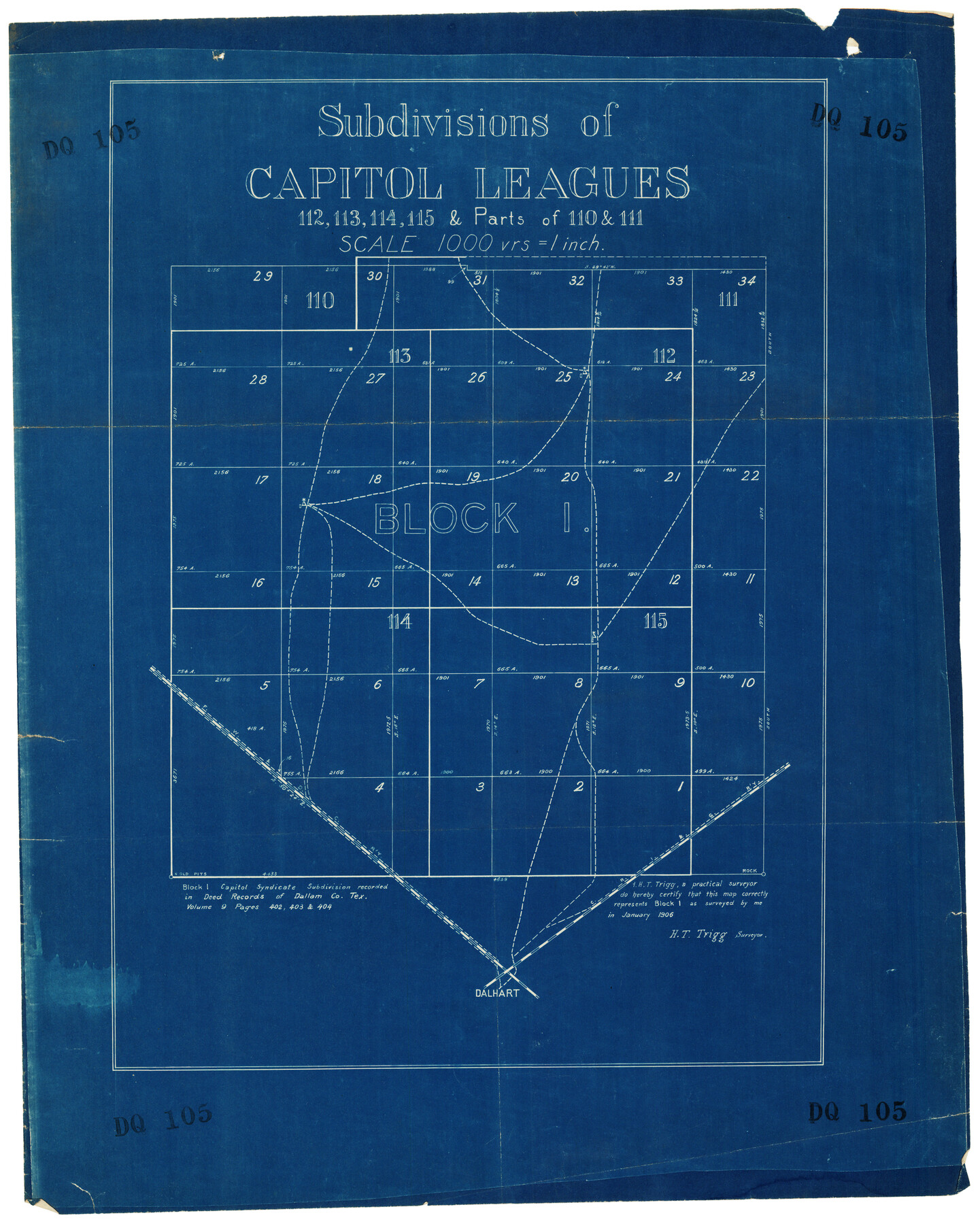
Subdivision of Capitol Leagues 112, 113, 114, and 115, and Parts of 110, and 111
DQ105
-
Map/Doc
92583
-
Collection
Twichell Survey Records
-
Object Dates
1/1906 (Creation Date)
-
People and Organizations
Howard T. Trigg (Surveyor/Engineer)
-
Counties
Dallam Dickens
-
Height x Width
18.5 x 23.3 inches
47.0 x 59.2 cm
Part of: Twichell Survey Records
Garden City Townsite, Section 5, Range 4 South, Block 33

Print $2.00
- Digital $50.00
Garden City Townsite, Section 5, Range 4 South, Block 33
1886
Size 9.0 x 15.4 inches
Map/Doc 90761
A Portion of Yoakum County, Texas and Gaines County, Texas in the vicinity of the Wasson Oil Field

Print $20.00
- Digital $50.00
A Portion of Yoakum County, Texas and Gaines County, Texas in the vicinity of the Wasson Oil Field
Size 43.4 x 32.0 inches
Map/Doc 90808
[Sketch showing Block 42, Sections 221 and 222 and Block H, Sections 7 and 9]
![91714, [Sketch showing Block 42, Sections 221 and 222 and Block H, Sections 7 and 9], Twichell Survey Records](https://historictexasmaps.com/wmedia_w700/maps/91714-1.tif.jpg)
Print $2.00
- Digital $50.00
[Sketch showing Block 42, Sections 221 and 222 and Block H, Sections 7 and 9]
1919
Size 5.6 x 5.0 inches
Map/Doc 91714
[Archer County School Land, Sections 1,2,3,4, Blocks GG, I, 29, A2, C3]
![92914, [Archer County School Land, Sections 1,2,3,4, Blocks GG, I, 29, A2, C3], Twichell Survey Records](https://historictexasmaps.com/wmedia_w700/maps/92914-1.tif.jpg)
Print $20.00
- Digital $50.00
[Archer County School Land, Sections 1,2,3,4, Blocks GG, I, 29, A2, C3]
Size 25.9 x 18.7 inches
Map/Doc 92914
[Blocks 34 and 35, Township 4N]
![92030, [Blocks 34 and 35, Township 4N], Twichell Survey Records](https://historictexasmaps.com/wmedia_w700/maps/92030-1.tif.jpg)
Print $20.00
- Digital $50.00
[Blocks 34 and 35, Township 4N]
Size 24.6 x 23.6 inches
Map/Doc 92030
Grimes Estate Lands, Cochran County, Texas

Print $20.00
- Digital $50.00
Grimes Estate Lands, Cochran County, Texas
Size 25.6 x 21.6 inches
Map/Doc 92520
[Block J and vicinity]
![91239, [Block J and vicinity], Twichell Survey Records](https://historictexasmaps.com/wmedia_w700/maps/91239-1.tif.jpg)
Print $20.00
- Digital $50.00
[Block J and vicinity]
Size 19.8 x 30.5 inches
Map/Doc 91239
Sketch Showing Original Corners Affecting Block I and Adjacent Surveys from Actual Connections by W. D. Twichell

Print $20.00
- Digital $50.00
Sketch Showing Original Corners Affecting Block I and Adjacent Surveys from Actual Connections by W. D. Twichell
Size 23.9 x 24.2 inches
Map/Doc 90285
[Blocks 21, 22, 23, and 24]
![91110, [Blocks 21, 22, 23, and 24], Twichell Survey Records](https://historictexasmaps.com/wmedia_w700/maps/91110-1.tif.jpg)
Print $20.00
- Digital $50.00
[Blocks 21, 22, 23, and 24]
Size 14.0 x 12.8 inches
Map/Doc 91110
[Garza County School Land and Vicinity]
![91294, [Garza County School Land and Vicinity], Twichell Survey Records](https://historictexasmaps.com/wmedia_w700/maps/91294-1.tif.jpg)
Print $3.00
- Digital $50.00
[Garza County School Land and Vicinity]
Size 13.4 x 11.9 inches
Map/Doc 91294
[Pencil Sketch of a portion of Block D-8]
![91872, [Pencil Sketch of a portion of Block D-8], Twichell Survey Records](https://historictexasmaps.com/wmedia_w700/maps/91872-1.tif.jpg)
Print $2.00
- Digital $50.00
[Pencil Sketch of a portion of Block D-8]
1937
Size 14.5 x 9.1 inches
Map/Doc 91872
Sketch from Reeves and Pecos Co's.

Print $20.00
- Digital $50.00
Sketch from Reeves and Pecos Co's.
Size 35.1 x 26.1 inches
Map/Doc 91779
You may also like
Dallam County Working Sketch Graphic Index

Print $40.00
- Digital $50.00
Dallam County Working Sketch Graphic Index
1926
Size 41.3 x 50.9 inches
Map/Doc 76516
Terrell County Working Sketch 73

Print $20.00
- Digital $50.00
Terrell County Working Sketch 73
1980
Size 29.0 x 47.5 inches
Map/Doc 69594
The Judicial District/Counties, Late Spring 1842

Print $20.00
The Judicial District/Counties, Late Spring 1842
2020
Size 24.5 x 21.7 inches
Map/Doc 96356
[Gulf Colorado & Santa Fe from 2178+36.0 to 3901+06.2]
![64698, [Gulf Colorado & Santa Fe from 2178+36.0 to 3901+06.2], General Map Collection](https://historictexasmaps.com/wmedia_w700/maps/64698.tif.jpg)
Print $40.00
- Digital $50.00
[Gulf Colorado & Santa Fe from 2178+36.0 to 3901+06.2]
Size 123.0 x 32.2 inches
Map/Doc 64698
[Pecos River Bed]
![2467, [Pecos River Bed], General Map Collection](https://historictexasmaps.com/wmedia_w700/maps/2467.tif.jpg)
Print $20.00
- Digital $50.00
[Pecos River Bed]
Size 16.6 x 39.8 inches
Map/Doc 2467
[Blocks K3-K8, K11]
![90507, [Blocks K3-K8, K11], Twichell Survey Records](https://historictexasmaps.com/wmedia_w700/maps/90507-1.tif.jpg)
Print $20.00
- Digital $50.00
[Blocks K3-K8, K11]
1887
Size 13.2 x 14.6 inches
Map/Doc 90507
[Southern Pacific Rail Road Co. Blocks 15 and 16 in Mitchell, Sterling and Coke Counties]
![91839, [Southern Pacific Rail Road Co. Blocks 15 and 16 in Mitchell, Sterling and Coke Counties], Twichell Survey Records](https://historictexasmaps.com/wmedia_w700/maps/91839-1.tif.jpg)
Print $20.00
- Digital $50.00
[Southern Pacific Rail Road Co. Blocks 15 and 16 in Mitchell, Sterling and Coke Counties]
Size 30.5 x 35.7 inches
Map/Doc 91839
Blanco County Working Sketch 16

Print $20.00
- Digital $50.00
Blanco County Working Sketch 16
1951
Size 22.2 x 19.5 inches
Map/Doc 67376
Moore County Rolled Sketch 9
Print $20.00
- Digital $50.00
Moore County Rolled Sketch 9
1911
Size 24.9 x 18.2 inches
Map/Doc 6827
Dallam County Sketch File 2

Print $260.00
- Digital $50.00
Dallam County Sketch File 2
1886
Size 29.9 x 17.4 inches
Map/Doc 11278
Matagorda County Rolled Sketch PHL

Print $20.00
- Digital $50.00
Matagorda County Rolled Sketch PHL
1937
Size 37.3 x 40.0 inches
Map/Doc 9476
Atascosa County Sketch File 30

Print $18.00
- Digital $50.00
Atascosa County Sketch File 30
1900
Size 11.2 x 8.8 inches
Map/Doc 13816