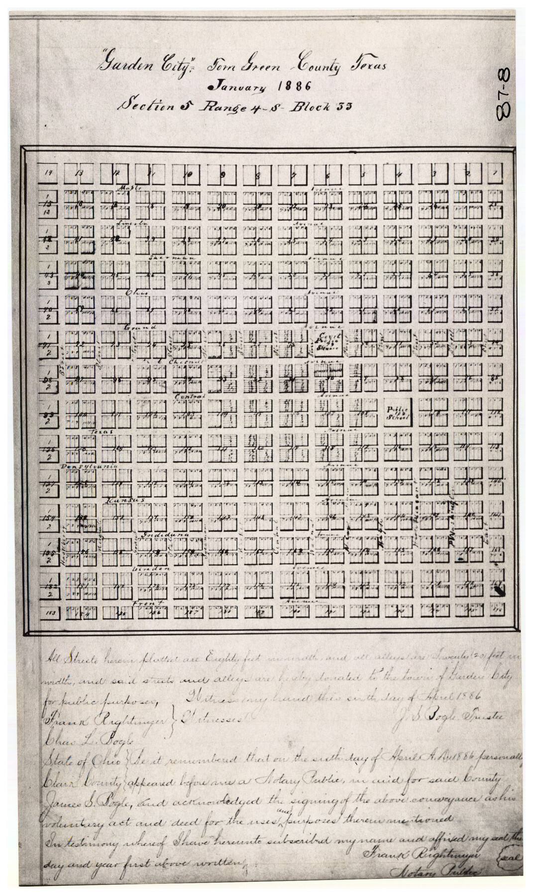
Garden City Townsite, Section 5, Range 4 South, Block 33
87-8
-
Map/Doc
90761
-
Collection
Twichell Survey Records
-
Object Dates
1/1886 (Creation Date)
-
Counties
Glasscock
-
Height x Width
9.0 x 15.4 inches
22.9 x 39.1 cm
Part of: Twichell Survey Records
[Rease Price and Surrounding Surveys]
![91228, [Rease Price and Surrounding Surveys], Twichell Survey Records](https://historictexasmaps.com/wmedia_w700/maps/91228-1.tif.jpg)
Print $20.00
- Digital $50.00
[Rease Price and Surrounding Surveys]
1924
Size 18.7 x 12.7 inches
Map/Doc 91228
![91464, [Block B7], Twichell Survey Records](https://historictexasmaps.com/wmedia_w700/maps/91464-1.tif.jpg)
Sketch Showing Original Corners and Connections Affecting Blocks T1, T2, and T3 in Lamb & Castro Counties

Print $20.00
- Digital $50.00
Sketch Showing Original Corners and Connections Affecting Blocks T1, T2, and T3 in Lamb & Castro Counties
Size 26.5 x 46.0 inches
Map/Doc 90405
[Sketch of part of G. & M. Block 5]
![93073, [Sketch of part of G. & M. Block 5], Twichell Survey Records](https://historictexasmaps.com/wmedia_w700/maps/93073-1.tif.jpg)
Print $2.00
- Digital $50.00
[Sketch of part of G. & M. Block 5]
Size 6.7 x 8.7 inches
Map/Doc 93073
[Surveys on the south side of the Canadian River]
![91788, [Surveys on the south side of the Canadian River], Twichell Survey Records](https://historictexasmaps.com/wmedia_w700/maps/91788-1.tif.jpg)
Print $3.00
- Digital $50.00
[Surveys on the south side of the Canadian River]
Size 11.2 x 15.9 inches
Map/Doc 91788
[Sketch of area just south of Levi Pruitt survey]
![91854, [Sketch of area just south of Levi Pruitt survey], Twichell Survey Records](https://historictexasmaps.com/wmedia_w700/maps/91854-1.tif.jpg)
Print $20.00
- Digital $50.00
[Sketch of area just south of Levi Pruitt survey]
Size 24.9 x 18.6 inches
Map/Doc 91854
[Blocks DD, C33, C32, C31, C36, C37, C38, C39, C41, C40, T]
![92935, [Blocks DD, C33, C32, C31, C36, C37, C38, C39, C41, C40, T], Twichell Survey Records](https://historictexasmaps.com/wmedia_w700/maps/92935-1.tif.jpg)
Print $20.00
- Digital $50.00
[Blocks DD, C33, C32, C31, C36, C37, C38, C39, C41, C40, T]
Size 44.0 x 24.8 inches
Map/Doc 92935
[Geo. W. Woodley, W. B. Ralls, Boyd Bros. and surrounding surveys]
![90455, [Geo. W. Woodley, W. B. Ralls, Boyd Bros. and surrounding surveys], Twichell Survey Records](https://historictexasmaps.com/wmedia_w700/maps/90455-1.tif.jpg)
Print $3.00
- Digital $50.00
[Geo. W. Woodley, W. B. Ralls, Boyd Bros. and surrounding surveys]
Size 11.7 x 12.6 inches
Map/Doc 90455
[Block XR, Capitol Leagues 161, 162, 164, 174, 178, 179, and 180]
![90661, [Block XR, Capitol Leagues 161, 162, 164, 174, 178, 179, and 180], Twichell Survey Records](https://historictexasmaps.com/wmedia_w700/maps/90661-1.tif.jpg)
Print $20.00
- Digital $50.00
[Block XR, Capitol Leagues 161, 162, 164, 174, 178, 179, and 180]
1908
Size 12.3 x 21.1 inches
Map/Doc 90661
Baker Addition to Lamesa, Part of Southwest Quarter Section 71, Block 35

Print $20.00
- Digital $50.00
Baker Addition to Lamesa, Part of Southwest Quarter Section 71, Block 35
Size 23.8 x 19.5 inches
Map/Doc 92576
Sketch in Northwest part Crockett County

Print $20.00
- Digital $50.00
Sketch in Northwest part Crockett County
Size 14.5 x 26.3 inches
Map/Doc 90475
Map B [showing surveys along river and in vicinity of Archer County School Land League 3]
![89752, Map B [showing surveys along river and in vicinity of Archer County School Land League 3], Twichell Survey Records](https://historictexasmaps.com/wmedia_w700/maps/89752-1.tif.jpg)
Print $20.00
- Digital $50.00
Map B [showing surveys along river and in vicinity of Archer County School Land League 3]
Size 42.7 x 38.0 inches
Map/Doc 89752
You may also like
Lamb County Sketch File 18

Print $4.00
- Digital $50.00
Lamb County Sketch File 18
1979
Size 14.3 x 8.9 inches
Map/Doc 29381
Gradient Boundary Survey of Canadian River through portions of Hutchinson & Roberts Counties, Texas

Print $40.00
- Digital $50.00
Gradient Boundary Survey of Canadian River through portions of Hutchinson & Roberts Counties, Texas
1989
Size 39.6 x 139.0 inches
Map/Doc 3120
Crockett County Rolled Sketch 88O

Print $126.00
- Digital $50.00
Crockett County Rolled Sketch 88O
1973
Size 9.8 x 15.1 inches
Map/Doc 44158
Harris County Sketch File 56a

Print $54.00
- Digital $50.00
Harris County Sketch File 56a
1912
Size 9.0 x 7.9 inches
Map/Doc 25456
Harris County Sketch File B

Print $4.00
- Digital $50.00
Harris County Sketch File B
1860
Size 8.0 x 5.5 inches
Map/Doc 25309
Guadalupe County Sketch File 5a

Print $12.00
- Digital $50.00
Guadalupe County Sketch File 5a
1869
Size 12.6 x 8.0 inches
Map/Doc 42205
Culberson County Sketch File 1c

Print $4.00
- Digital $50.00
Culberson County Sketch File 1c
1859
Size 7.4 x 8.0 inches
Map/Doc 20111
Baylor County Sketch File 1a

Print $8.00
- Digital $50.00
Baylor County Sketch File 1a
1857
Size 8.2 x 7.9 inches
Map/Doc 14144
Coleman County Working Sketch 20
Print $20.00
- Digital $50.00
Coleman County Working Sketch 20
1953
Size 32.7 x 41.9 inches
Map/Doc 68086
Potter County Boundary File 3

Print $10.00
- Digital $50.00
Potter County Boundary File 3
Size 5.8 x 8.9 inches
Map/Doc 57974
Photostat of section of hydrographic surveys H-5399, H-4822, H-470

Print $20.00
- Digital $50.00
Photostat of section of hydrographic surveys H-5399, H-4822, H-470
1933
Size 18.3 x 25.8 inches
Map/Doc 61156
Blocks 2, 8, and 9. Capitol Syndicate Subdivision of Capitol Leagues or Portions of Capitol Leagues 59, 60, 61, 62, 63, 64, 65, 66, 69, 70, 71, 72, 73, 74, 75, 76, 83, 84, 85, 86, 87, 88, 89, 90, 91, 92, 108, 109, and 110. Dallam County, Texas

Print $20.00
- Digital $50.00
Blocks 2, 8, and 9. Capitol Syndicate Subdivision of Capitol Leagues or Portions of Capitol Leagues 59, 60, 61, 62, 63, 64, 65, 66, 69, 70, 71, 72, 73, 74, 75, 76, 83, 84, 85, 86, 87, 88, 89, 90, 91, 92, 108, 109, and 110. Dallam County, Texas
1906
Size 31.7 x 28.3 inches
Map/Doc 92581