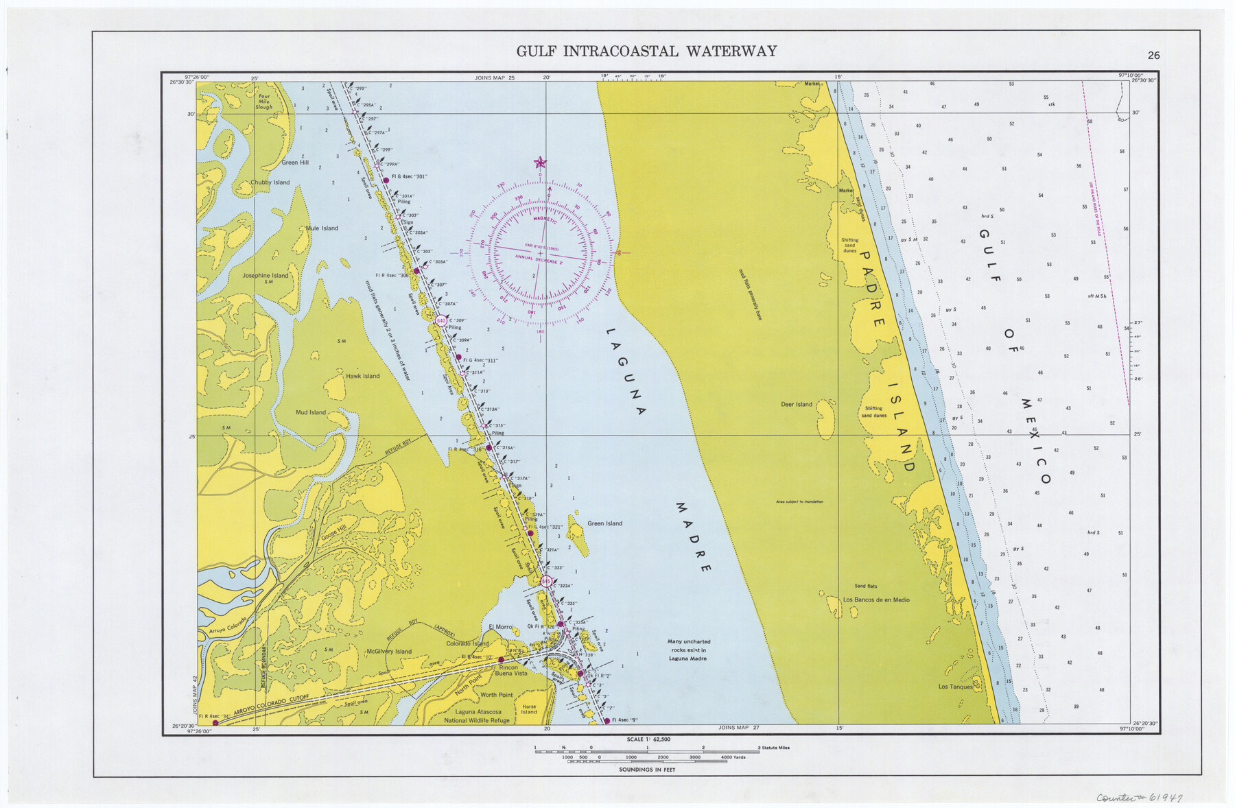
Maps of Gulf Intracoastal Waterway, Texas - Sabine River to the Rio Grande and connecting waterways including ship channels
-
Map/Doc
61947
-
Collection
General Map Collection
-
Object Dates
1966 (Creation Date)
-
Subjects
Intracoastal Waterways
-
Height x Width
14.6 x 22.2 inches
37.1 x 56.4 cm
Part of: General Map Collection
Runnels County Working Sketch 25

Print $20.00
- Digital $50.00
Runnels County Working Sketch 25
1955
Size 38.2 x 47.1 inches
Map/Doc 63621
Liberty County Rolled Sketch O

Print $40.00
- Digital $50.00
Liberty County Rolled Sketch O
1954
Size 52.3 x 42.8 inches
Map/Doc 10720
Uvalde County Boundary File 3

Print $28.00
- Digital $50.00
Uvalde County Boundary File 3
Size 13.1 x 8.4 inches
Map/Doc 59558
Flight Mission No. DQO-3K, Frame 17, Galveston County

Print $20.00
- Digital $50.00
Flight Mission No. DQO-3K, Frame 17, Galveston County
1952
Size 18.9 x 22.5 inches
Map/Doc 85058
Mills County Sketch File 5

Print $4.00
- Digital $50.00
Mills County Sketch File 5
Size 11.5 x 8.3 inches
Map/Doc 31652
Wise County Sketch File A

Print $8.00
- Digital $50.00
Wise County Sketch File A
1884
Size 9.1 x 8.1 inches
Map/Doc 40609
Cameron County Rolled Sketch US1

Print $20.00
- Digital $50.00
Cameron County Rolled Sketch US1
1913
Size 21.2 x 25.3 inches
Map/Doc 5399
Sabine County Working Sketch 3

Print $3.00
- Digital $50.00
Sabine County Working Sketch 3
1911
Size 10.8 x 15.7 inches
Map/Doc 63674
Matagorda County Rolled Sketch PHL1

Print $20.00
- Digital $50.00
Matagorda County Rolled Sketch PHL1
Size 36.5 x 39.1 inches
Map/Doc 9477
Hidalgo County Working Sketch 10

Print $40.00
- Digital $50.00
Hidalgo County Working Sketch 10
2011
Size 59.9 x 29.5 inches
Map/Doc 89998
Orange County Sketch File 15

Print $6.00
- Digital $50.00
Orange County Sketch File 15
1900
Size 11.0 x 15.4 inches
Map/Doc 33330
Nueces County Rolled Sketch 109

Print $20.00
- Digital $50.00
Nueces County Rolled Sketch 109
1989
Size 18.8 x 25.0 inches
Map/Doc 7116
You may also like
Webb County Rolled Sketch EF5

Print $20.00
- Digital $50.00
Webb County Rolled Sketch EF5
1931
Size 41.4 x 32.0 inches
Map/Doc 8227

Parker County Sketch File C

Print $4.00
- Digital $50.00
Parker County Sketch File C
1857
Size 6.1 x 7.8 inches
Map/Doc 33512
Crockett County Rolled Sketch 88M

Print $20.00
- Digital $50.00
Crockett County Rolled Sketch 88M
1964
Size 25.2 x 34.2 inches
Map/Doc 5629
[Sketch for Mineral Application 24072, San Jacinto River]
![65608, [Sketch for Mineral Application 24072, San Jacinto River], General Map Collection](https://historictexasmaps.com/wmedia_w700/maps/65608.tif.jpg)
Print $20.00
- Digital $50.00
[Sketch for Mineral Application 24072, San Jacinto River]
1929
Size 8.6 x 14.0 inches
Map/Doc 65608
Somervell County Sketch File 2

Print $20.00
- Digital $50.00
Somervell County Sketch File 2
1847
Size 21.8 x 16.7 inches
Map/Doc 12325
Flight Mission No. BRE-1P, Frame 129, Nueces County

Print $20.00
- Digital $50.00
Flight Mission No. BRE-1P, Frame 129, Nueces County
1956
Size 18.5 x 22.6 inches
Map/Doc 86695
Cooke County Sketch File 20

Print $22.00
- Digital $50.00
Cooke County Sketch File 20
1862
Size 9.1 x 6.9 inches
Map/Doc 19264
Ownership Map SE 1/4 Lubbock County

Print $20.00
- Digital $50.00
Ownership Map SE 1/4 Lubbock County
Size 36.6 x 35.9 inches
Map/Doc 89898
Flight Mission No. DIX-8P, Frame 71, Aransas County

Print $20.00
- Digital $50.00
Flight Mission No. DIX-8P, Frame 71, Aransas County
1956
Size 18.8 x 22.4 inches
Map/Doc 83902

Chambers County Sketch File 42

Print $149.00
- Digital $50.00
Chambers County Sketch File 42
1917
Size 14.3 x 8.8 inches
Map/Doc 17700