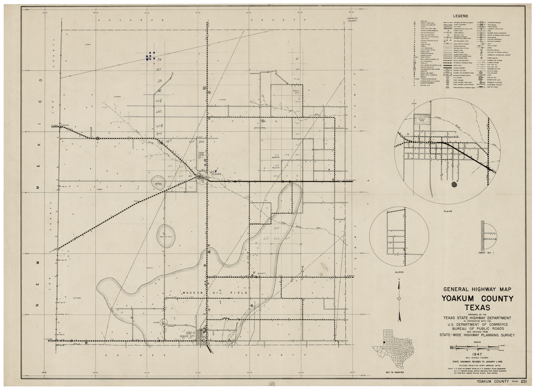
General Highway Map, Yoakum County Texas
-
Map/Doc
92815
-
Collection
Twichell Survey Records
-
Object Dates
1/1/1952 (Creation Date)
-
Counties
Yoakum
-
Subjects
County
-
Height x Width
26.3 x 19.1 inches
66.8 x 48.5 cm
Part of: Twichell Survey Records
[Blocks D, Q, and Z]
![92522, [Blocks D, Q, and Z], Twichell Survey Records](https://historictexasmaps.com/wmedia_w700/maps/92522-1.tif.jpg)
Print $20.00
- Digital $50.00
[Blocks D, Q, and Z]
Size 17.9 x 22.6 inches
Map/Doc 92522
![91447, [Block K5], Twichell Survey Records](https://historictexasmaps.com/wmedia_w700/maps/91447-1.tif.jpg)
Archer County

Print $20.00
- Digital $50.00
Archer County
1898
Size 36.0 x 39.4 inches
Map/Doc 93033
[Blocks M23, XO2, Z, and 47]
![91242, [Blocks M23, XO2, Z, and 47], Twichell Survey Records](https://historictexasmaps.com/wmedia_w700/maps/91242-1.tif.jpg)
Print $20.00
- Digital $50.00
[Blocks M23, XO2, Z, and 47]
Size 19.0 x 19.5 inches
Map/Doc 91242
Blocks 3 and 4 Capitol Syndicate Subdivision of Capitol Leagues 93, 94, 95, 96, 104, 105, 106, 107, 116, 117, 118, 127, 128, 129, 130, 131, 132, 140, 141, 142, and Parts of 75, 83, 84, 85, 86, 108, 143, 144, and 145

Print $20.00
- Digital $50.00
Blocks 3 and 4 Capitol Syndicate Subdivision of Capitol Leagues 93, 94, 95, 96, 104, 105, 106, 107, 116, 117, 118, 127, 128, 129, 130, 131, 132, 140, 141, 142, and Parts of 75, 83, 84, 85, 86, 108, 143, 144, and 145
1906
Size 18.1 x 29.2 inches
Map/Doc 92582
[Sketch showing sections 6, 7, 16, 32, 42 and 43]
![91775, [Sketch showing sections 6, 7, 16, 32, 42 and 43], Twichell Survey Records](https://historictexasmaps.com/wmedia_w700/maps/91775-1.tif.jpg)
Print $3.00
- Digital $50.00
[Sketch showing sections 6, 7, 16, 32, 42 and 43]
Size 14.5 x 11.2 inches
Map/Doc 91775
[H. & T. C. , Block 47, Sections 26- 38]
![91255, [H. & T. C. , Block 47, Sections 26- 38], Twichell Survey Records](https://historictexasmaps.com/wmedia_w700/maps/91255-1.tif.jpg)
Print $2.00
- Digital $50.00
[H. & T. C. , Block 47, Sections 26- 38]
Size 14.5 x 9.2 inches
Map/Doc 91255
[LIT Ranch, Gunter & Munson surveys 52-55, Canadian River Meander]
![93011, [LIT Ranch, Gunter & Munson surveys 52-55, Canadian River Meander], Twichell Survey Records](https://historictexasmaps.com/wmedia_w700/maps/93011-1.tif.jpg)
Print $20.00
- Digital $50.00
[LIT Ranch, Gunter & Munson surveys 52-55, Canadian River Meander]
Size 18.4 x 12.8 inches
Map/Doc 93011
[Littlefield Subdivision Blocks 657-687]
![91009, [Littlefield Subdivision Blocks 657-687], Twichell Survey Records](https://historictexasmaps.com/wmedia_w700/maps/91009-1.tif.jpg)
Print $20.00
- Digital $50.00
[Littlefield Subdivision Blocks 657-687]
Size 31.2 x 20.5 inches
Map/Doc 91009
Survey of Improvements on Meeks Gin Site Town of Ropes Hockley County, Texas

Print $20.00
- Digital $50.00
Survey of Improvements on Meeks Gin Site Town of Ropes Hockley County, Texas
1957
Size 13.0 x 17.6 inches
Map/Doc 92214
[Hockley County Sketch, Mineral Application Number 38322- 38379]
![91203, [Hockley County Sketch, Mineral Application Number 38322- 38379], Twichell Survey Records](https://historictexasmaps.com/wmedia_w700/maps/91203-1.tif.jpg)
Print $20.00
- Digital $50.00
[Hockley County Sketch, Mineral Application Number 38322- 38379]
1946
Size 43.5 x 26.7 inches
Map/Doc 91203

You may also like
[Block 1 PO, Surveys 15, 16, and 17]
![91433, [Block 1 PO, Surveys 15, 16, and 17], Twichell Survey Records](https://historictexasmaps.com/wmedia_w700/maps/91433-1.tif.jpg)
Print $20.00
- Digital $50.00
[Block 1 PO, Surveys 15, 16, and 17]
1906
Size 16.6 x 15.6 inches
Map/Doc 91433
Flight Mission No. DAG-18K, Frame 74, Matagorda County

Print $20.00
- Digital $50.00
Flight Mission No. DAG-18K, Frame 74, Matagorda County
1952
Size 18.5 x 22.4 inches
Map/Doc 86367
Harris County Historic Topographic 21

Print $20.00
- Digital $50.00
Harris County Historic Topographic 21
1915
Size 29.2 x 22.5 inches
Map/Doc 65832
[Archer County School Land]
![90324, [Archer County School Land], Twichell Survey Records](https://historictexasmaps.com/wmedia_w700/maps/90324-1.tif.jpg)
Print $20.00
- Digital $50.00
[Archer County School Land]
Size 21.7 x 16.7 inches
Map/Doc 90324
Texas and Northern Mexico

Print $20.00
- Digital $50.00
Texas and Northern Mexico
1900
Size 21.6 x 28.6 inches
Map/Doc 95895
Brewster County Rolled Sketch 60

Print $40.00
- Digital $50.00
Brewster County Rolled Sketch 60
Size 36.6 x 50.3 inches
Map/Doc 10692
Marion County Sketch File 10

Print $4.00
- Digital $50.00
Marion County Sketch File 10
1867
Size 7.9 x 12.4 inches
Map/Doc 30579
[Block H, Block 24]
![92598, [Block H, Block 24], Twichell Survey Records](https://historictexasmaps.com/wmedia_w700/maps/92598-1.tif.jpg)
Print $20.00
- Digital $50.00
[Block H, Block 24]
Size 30.2 x 17.0 inches
Map/Doc 92598
Map of a part of Laguna Madre showing subdivision for mineral development

Print $40.00
- Digital $50.00
Map of a part of Laguna Madre showing subdivision for mineral development
1946
Size 50.0 x 29.0 inches
Map/Doc 2915
The Republic County of Fannin. Created, December 14, 1837

Print $20.00
The Republic County of Fannin. Created, December 14, 1837
2020
Size 15.0 x 21.7 inches
Map/Doc 96128
Karnes County Working Sketch 5

Print $20.00
- Digital $50.00
Karnes County Working Sketch 5
1960
Size 37.2 x 36.8 inches
Map/Doc 66653
Medina County Working Sketch 1

Print $20.00
- Digital $50.00
Medina County Working Sketch 1
1915
Size 14.2 x 14.2 inches
Map/Doc 70916