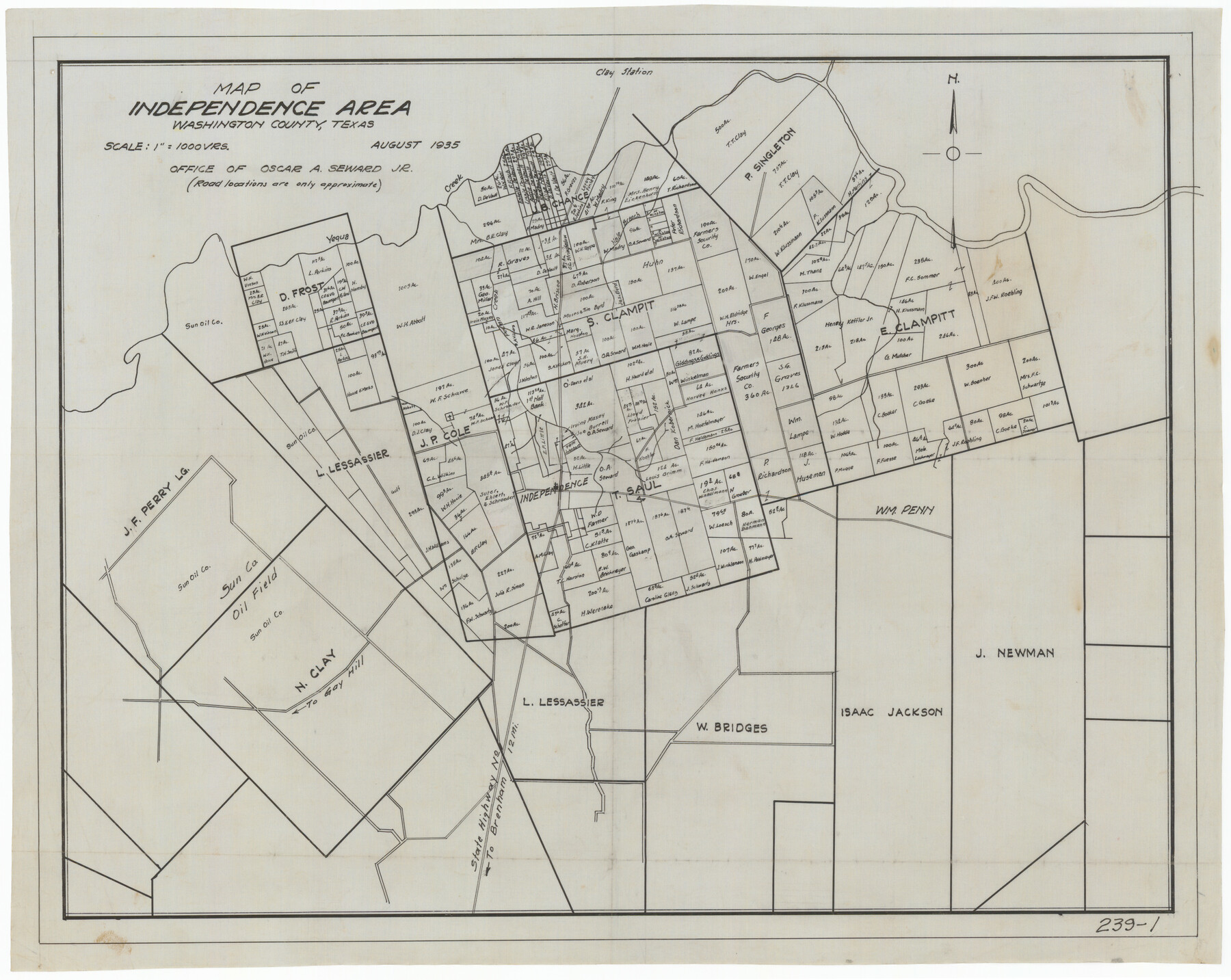
Map of Independence Area, Washington County, Texas
239-1
-
Map/Doc
91989
-
Collection
Twichell Survey Records
-
Object Dates
8/1935 (Creation Date)
-
Counties
Washington
-
Height x Width
24.0 x 19.1 inches
61.0 x 48.5 cm
Part of: Twichell Survey Records
[Sketch showing area around Runnels County School Land, Yates survey 34 1/2 and Runnels County School Land]
![91683, [Sketch showing area around Runnels County School Land, Yates survey 34 1/2 and Runnels County School Land], Twichell Survey Records](https://historictexasmaps.com/wmedia_w700/maps/91683-1.tif.jpg)
Print $20.00
- Digital $50.00
[Sketch showing area around Runnels County School Land, Yates survey 34 1/2 and Runnels County School Land]
Size 17.5 x 12.5 inches
Map/Doc 91683
[Southwest part of H. & G. N. Block 8]
![90372, [Southwest part of H. & G. N. Block 8], Twichell Survey Records](https://historictexasmaps.com/wmedia_w700/maps/90372-1.tif.jpg)
Print $20.00
- Digital $50.00
[Southwest part of H. & G. N. Block 8]
Size 24.6 x 9.3 inches
Map/Doc 90372
[Block B, Sections 1-4]
![90984, [Block B, Sections 1-4], Twichell Survey Records](https://historictexasmaps.com/wmedia_w700/maps/90984-1.tif.jpg)
Print $20.00
- Digital $50.00
[Block B, Sections 1-4]
Size 21.8 x 20.5 inches
Map/Doc 90984
[H. & G. N. RR. Co. Blks. 1 & 2]
![89771, [H. & G. N. RR. Co. Blks. 1 & 2], Twichell Survey Records](https://historictexasmaps.com/wmedia_w700/maps/89771-1.tif.jpg)
Print $20.00
- Digital $50.00
[H. & G. N. RR. Co. Blks. 1 & 2]
Size 40.9 x 46.6 inches
Map/Doc 89771
[Portions of Hansford and Hutchinson Counties]
![91136, [Portions of Hansford and Hutchinson Counties], Twichell Survey Records](https://historictexasmaps.com/wmedia_w700/maps/91136-1.tif.jpg)
Print $3.00
- Digital $50.00
[Portions of Hansford and Hutchinson Counties]
Size 11.5 x 13.5 inches
Map/Doc 91136
Hutchinson County, 1922

Print $20.00
- Digital $50.00
Hutchinson County, 1922
1922
Size 36.5 x 47.6 inches
Map/Doc 89699
Portion of Lands in Parmer County, Texas Owned and For Sale by Capitol Freehold Land and Investment Co., Ltd.

Print $3.00
- Digital $50.00
Portion of Lands in Parmer County, Texas Owned and For Sale by Capitol Freehold Land and Investment Co., Ltd.
Size 16.7 x 11.3 inches
Map/Doc 91550
Bravo Ranch situated in Hartley and Oldham Counties, Texas

Print $40.00
- Digital $50.00
Bravo Ranch situated in Hartley and Oldham Counties, Texas
Size 38.8 x 51.3 inches
Map/Doc 89930
Part of Garza, Crosby, Lynn and Lubbock Counties

Print $20.00
- Digital $50.00
Part of Garza, Crosby, Lynn and Lubbock Counties
1912
Size 24.6 x 19.8 inches
Map/Doc 90907
Ownership Map Hockley County, Texas

Print $20.00
- Digital $50.00
Ownership Map Hockley County, Texas
Size 19.1 x 20.4 inches
Map/Doc 92208
Winkler County

Print $20.00
- Digital $50.00
Winkler County
1901
Size 36.2 x 45.8 inches
Map/Doc 93038
[Sketch showing Leagues 464, 467-472, 483-489, 495, 510, 517, 532, 541, 556-570]
![89802, [Sketch showing Leagues 464, 467-472, 483-489, 495, 510, 517, 532, 541, 556-570], Twichell Survey Records](https://historictexasmaps.com/wmedia_w700/maps/89802-1.tif.jpg)
Print $20.00
- Digital $50.00
[Sketch showing Leagues 464, 467-472, 483-489, 495, 510, 517, 532, 541, 556-570]
Size 44.8 x 42.7 inches
Map/Doc 89802
You may also like
La Salle County Working Sketch 10

Print $20.00
- Digital $50.00
La Salle County Working Sketch 10
1928
Size 30.6 x 20.5 inches
Map/Doc 70311
Flight Mission No. BRE-5P, Frame 199, Nueces County

Print $20.00
- Digital $50.00
Flight Mission No. BRE-5P, Frame 199, Nueces County
1956
Size 18.4 x 22.3 inches
Map/Doc 86839
Culberson County Sketch File 5a

Print $44.00
- Digital $50.00
Culberson County Sketch File 5a
Size 14.2 x 8.8 inches
Map/Doc 20169
Zavala County Working Sketch 13

Print $20.00
- Digital $50.00
Zavala County Working Sketch 13
1975
Size 20.1 x 27.4 inches
Map/Doc 62088
Bell County Working Sketch 3

Print $3.00
- Digital $50.00
Bell County Working Sketch 3
1940
Size 10.8 x 12.8 inches
Map/Doc 67343
Moore County Sketch File X

Print $20.00
- Digital $50.00
Moore County Sketch File X
Size 34.3 x 24.6 inches
Map/Doc 42131
Tarrant County Sketch File 16

Print $4.00
- Digital $50.00
Tarrant County Sketch File 16
1861
Size 8.2 x 6.4 inches
Map/Doc 37710
Kinney County Working Sketch 10

Print $20.00
- Digital $50.00
Kinney County Working Sketch 10
1933
Size 23.1 x 18.4 inches
Map/Doc 70192
Blanco County Sketch File 25

Print $40.00
- Digital $50.00
Blanco County Sketch File 25
1888
Size 17.1 x 14.2 inches
Map/Doc 14616
[Leagues 1, 2, 281, 282, 284, and 285]
![92563, [Leagues 1, 2, 281, 282, 284, and 285], Twichell Survey Records](https://historictexasmaps.com/wmedia_w700/maps/92563-1.tif.jpg)
Print $20.00
- Digital $50.00
[Leagues 1, 2, 281, 282, 284, and 285]
Size 23.8 x 19.3 inches
Map/Doc 92563
1882 Map of the Texas & Pacific R-Y Reserve

Print $20.00
- Digital $50.00
1882 Map of the Texas & Pacific R-Y Reserve
1887
Size 44.5 x 31.7 inches
Map/Doc 83559
Current Miscellaneous File 98

Print $40.00
- Digital $50.00
Current Miscellaneous File 98
Size 18.4 x 26.3 inches
Map/Doc 74338