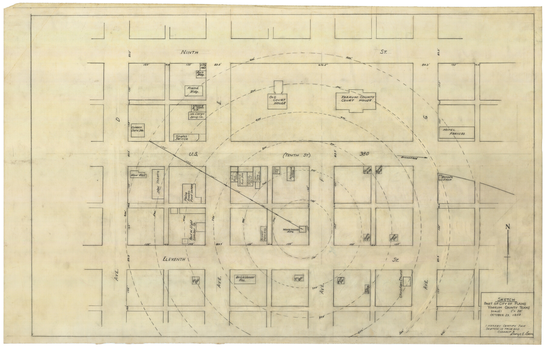
Part of City of Plains
-
Map/Doc
92449
-
Collection
Twichell Survey Records
-
People and Organizations
George E. Bean (Surveyor/Engineer)
-
Counties
Yoakum
-
Height x Width
37.1 x 23.6 inches
94.2 x 59.9 cm
Part of: Twichell Survey Records
Oil and Gas Fields of the State of Texas

Print $40.00
- Digital $50.00
Oil and Gas Fields of the State of Texas
1931
Size 38.4 x 59.2 inches
Map/Doc 89885
[Area north of Leagues 1 & 4, Morris County School Land]
![90353, [Area north of Leagues 1 & 4, Morris County School Land], Twichell Survey Records](https://historictexasmaps.com/wmedia_w700/maps/90353-1.tif.jpg)
Print $20.00
- Digital $50.00
[Area north of Leagues 1 & 4, Morris County School Land]
Size 21.3 x 16.0 inches
Map/Doc 90353
[King, Knox & Stonewall Counties]
![92916, [King, Knox & Stonewall Counties], Twichell Survey Records](https://historictexasmaps.com/wmedia_w700/maps/92916-1.tif.jpg)
Print $20.00
- Digital $50.00
[King, Knox & Stonewall Counties]
1902
Size 19.6 x 28.1 inches
Map/Doc 92916
W. L. Ellwood's O Ranch, Lubbock and Hockley Co.

Print $20.00
- Digital $50.00
W. L. Ellwood's O Ranch, Lubbock and Hockley Co.
Size 15.5 x 23.8 inches
Map/Doc 92762
[Strickland Survey Sketch Showing Abercrombie Corner, Exhibit C]
![91370, [Strickland Survey Sketch Showing Abercrombie Corner, Exhibit C], Twichell Survey Records](https://historictexasmaps.com/wmedia_w700/maps/91370-1.tif.jpg)
Print $20.00
- Digital $50.00
[Strickland Survey Sketch Showing Abercrombie Corner, Exhibit C]
Size 25.3 x 19.1 inches
Map/Doc 91370
[Blocks 5-T, R-2, M-24, and M-23]
![91149, [Blocks 5-T, R-2, M-24, and M-23], Twichell Survey Records](https://historictexasmaps.com/wmedia_w700/maps/91149-1.tif.jpg)
Print $20.00
- Digital $50.00
[Blocks 5-T, R-2, M-24, and M-23]
Size 15.5 x 19.7 inches
Map/Doc 91149
[Subdivision of Lgs. 109-112, Crosby County School Land]
![90154, [Subdivision of Lgs. 109-112, Crosby County School Land], Twichell Survey Records](https://historictexasmaps.com/wmedia_w700/maps/90154-1.tif.jpg)
Print $20.00
- Digital $50.00
[Subdivision of Lgs. 109-112, Crosby County School Land]
Size 11.8 x 21.3 inches
Map/Doc 90154
[North County Line]
![90521, [North County Line], Twichell Survey Records](https://historictexasmaps.com/wmedia_w700/maps/90521-1.tif.jpg)
Print $3.00
- Digital $50.00
[North County Line]
Size 17.3 x 6.6 inches
Map/Doc 90521
Eastern South America Brazil, Paraguay, Uruguay, and the Guianas

Eastern South America Brazil, Paraguay, Uruguay, and the Guianas
1955
Size 29.8 x 41.2 inches
Map/Doc 92389
[H. & T. C. Block 34 and PSL Block B-19]
![91948, [H. & T. C. Block 34 and PSL Block B-19], Twichell Survey Records](https://historictexasmaps.com/wmedia_w700/maps/91948-1.tif.jpg)
Print $20.00
- Digital $50.00
[H. & T. C. Block 34 and PSL Block B-19]
Size 30.6 x 30.6 inches
Map/Doc 91948
[T. H. Jones Blk. O, Blk. F, Coyote Lake Area, Sutton County School Land Leagues]
![90246, [T. H. Jones Blk. O, Blk. F, Coyote Lake Area, Sutton County School Land Leagues], Twichell Survey Records](https://historictexasmaps.com/wmedia_w700/maps/90246-1.tif.jpg)
Print $20.00
- Digital $50.00
[T. H. Jones Blk. O, Blk. F, Coyote Lake Area, Sutton County School Land Leagues]
Size 21.0 x 33.6 inches
Map/Doc 90246
North Part Brewster Co.

Print $40.00
- Digital $50.00
North Part Brewster Co.
1914
Size 48.4 x 37.8 inches
Map/Doc 89864
You may also like
Flight Mission No. DQN-2K, Frame 134, Calhoun County

Print $20.00
- Digital $50.00
Flight Mission No. DQN-2K, Frame 134, Calhoun County
1953
Size 18.8 x 22.4 inches
Map/Doc 84303
Terrell County Rolled Sketch 60

Print $20.00
- Digital $50.00
Terrell County Rolled Sketch 60
1998
Size 13.2 x 38.1 inches
Map/Doc 7976
Comanche County

Print $20.00
- Digital $50.00
Comanche County
1896
Size 40.5 x 45.1 inches
Map/Doc 66783
Coryell County Working Sketch 6

Print $20.00
- Digital $50.00
Coryell County Working Sketch 6
1941
Size 15.9 x 13.6 inches
Map/Doc 68213
Galveston County Rolled Sketch 47

Print $20.00
- Digital $50.00
Galveston County Rolled Sketch 47
1999
Size 24.6 x 36.7 inches
Map/Doc 77534
Hunt County Sketch File 17

Print $8.00
- Digital $50.00
Hunt County Sketch File 17
1861
Size 10.6 x 8.2 inches
Map/Doc 27114
Hood County Sketch File 12

Print $35.00
- Digital $50.00
Hood County Sketch File 12
Size 9.0 x 9.7 inches
Map/Doc 26590
[Field Notes attached to Sketch of North Line of Deaf Smith County and South Line of Oldham County]
![91407, [Field Notes attached to Sketch of North Line of Deaf Smith County and South Line of Oldham County], Twichell Survey Records](https://historictexasmaps.com/wmedia_w700/maps/91407-1.tif.jpg)
Print $20.00
- Digital $50.00
[Field Notes attached to Sketch of North Line of Deaf Smith County and South Line of Oldham County]
1894
Size 40.6 x 20.0 inches
Map/Doc 91407
Controlled Mosaic by Jack Amman Photogrammetric Engineers, Inc - Sheet 10

Print $20.00
- Digital $50.00
Controlled Mosaic by Jack Amman Photogrammetric Engineers, Inc - Sheet 10
1954
Size 20.0 x 24.0 inches
Map/Doc 83454
Flight Mission No. BRA-7M, Frame 81, Jefferson County

Print $20.00
- Digital $50.00
Flight Mission No. BRA-7M, Frame 81, Jefferson County
1953
Size 16.0 x 15.8 inches
Map/Doc 85503
Colorado County Sketch File 21

Print $8.00
- Digital $50.00
Colorado County Sketch File 21
Size 13.1 x 8.8 inches
Map/Doc 18957
Topographisch-geognostische Karte von Texas mit Zugrundelegung der geographischen Karte v. Wilson nach eigenen Beobachtungen bearbeitet von Dr. Ferd. Roemer

Print $20.00
- Digital $50.00
Topographisch-geognostische Karte von Texas mit Zugrundelegung der geographischen Karte v. Wilson nach eigenen Beobachtungen bearbeitet von Dr. Ferd. Roemer
1849
Size 23.5 x 21.0 inches
Map/Doc 96523