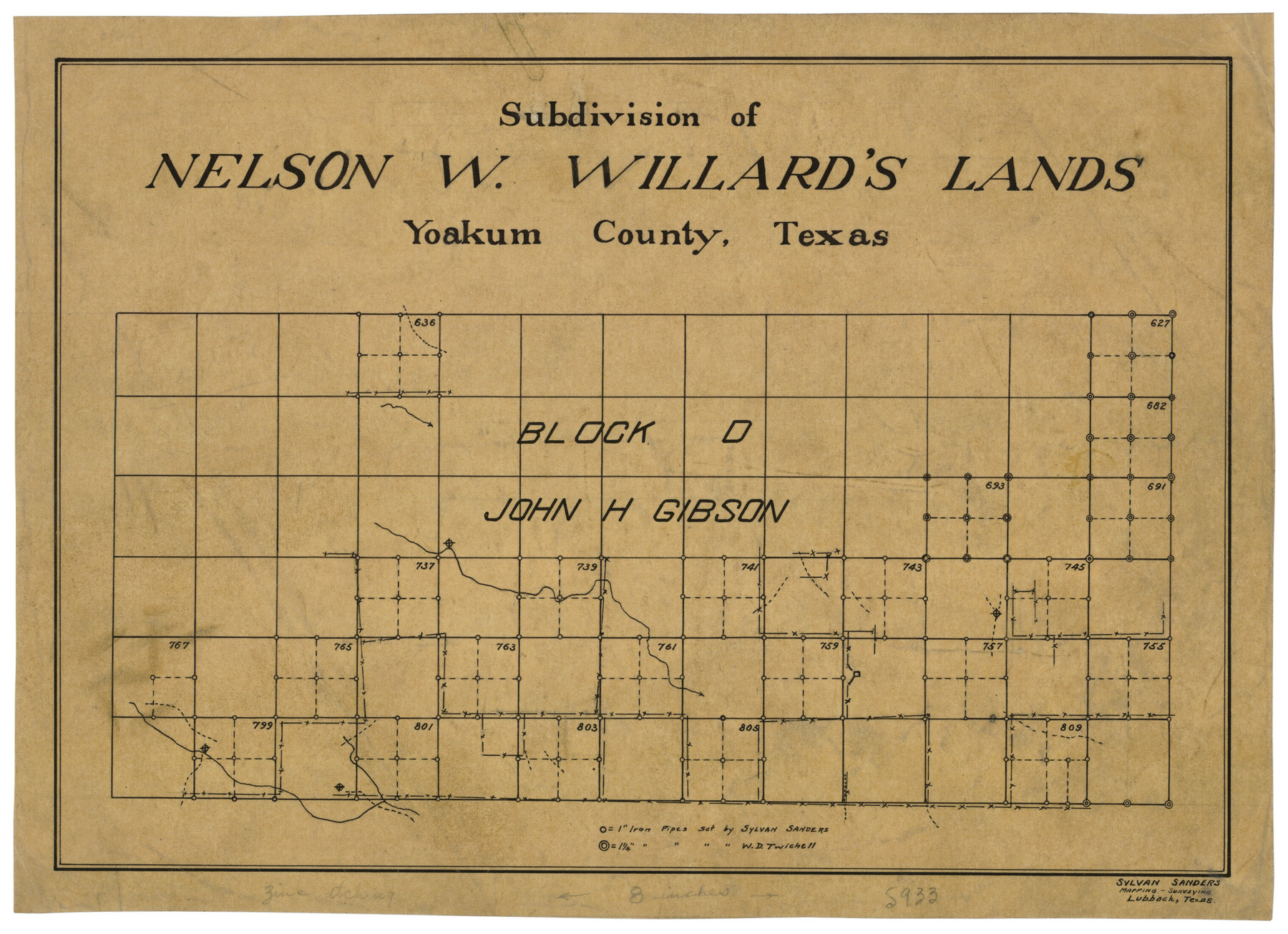
Subdivision of Nelson W. Willard's Lands
-
Map/Doc
92448
-
Collection
Twichell Survey Records
-
People and Organizations
Sylvan Sanders (Surveyor/Engineer)
-
Counties
Yoakum
-
Height x Width
15.0 x 10.8 inches
38.1 x 27.4 cm
Part of: Twichell Survey Records
![89869, [Morton], Twichell Survey Records](https://historictexasmaps.com/wmedia_w700/maps/89869-1.tif.jpg)
Hockley County, Texas

Print $20.00
- Digital $50.00
Hockley County, Texas
Size 34.4 x 37.5 inches
Map/Doc 92247
Ellwood Farms, Situated in Lamb County, Texas

Print $20.00
- Digital $50.00
Ellwood Farms, Situated in Lamb County, Texas
Size 12.7 x 23.1 inches
Map/Doc 90994
[H. & T. C. RR. Company, Block 47]
![91162, [H. & T. C. RR. Company, Block 47], Twichell Survey Records](https://historictexasmaps.com/wmedia_w700/maps/91162-1.tif.jpg)
Print $20.00
- Digital $50.00
[H. & T. C. RR. Company, Block 47]
1921
Size 13.1 x 20.6 inches
Map/Doc 91162
[Part of Eastern Texas RR. Co. Block 1]
![91920, [Part of Eastern Texas RR. Co. Block 1], Twichell Survey Records](https://historictexasmaps.com/wmedia_w700/maps/91920-1.tif.jpg)
Print $20.00
- Digital $50.00
[Part of Eastern Texas RR. Co. Block 1]
Size 35.7 x 15.6 inches
Map/Doc 91920
Oldham and Hartley Counties Sketch

Print $20.00
- Digital $50.00
Oldham and Hartley Counties Sketch
1906
Size 16.1 x 17.1 inches
Map/Doc 90671
[Block O1, Godair]
![90566, [Block O1, Godair], Twichell Survey Records](https://historictexasmaps.com/wmedia_w700/maps/90566-1.tif.jpg)
Print $20.00
- Digital $50.00
[Block O1, Godair]
Size 22.7 x 18.0 inches
Map/Doc 90566
![90608, [Block K11], Twichell Survey Records](https://historictexasmaps.com/wmedia_w700/maps/90608-1.tif.jpg)
[Blocks 44 and 6T]
![91410, [Blocks 44 and 6T], Twichell Survey Records](https://historictexasmaps.com/wmedia_w700/maps/91410-1.tif.jpg)
Print $20.00
- Digital $50.00
[Blocks 44 and 6T]
Size 29.3 x 17.4 inches
Map/Doc 91410
[Texas and Pacific Railway Company, Block 44, Township One South]
![89846, [Texas and Pacific Railway Company, Block 44, Township One South], Twichell Survey Records](https://historictexasmaps.com/wmedia_w700/maps/89846-1.tif.jpg)
Print $40.00
- Digital $50.00
[Texas and Pacific Railway Company, Block 44, Township One South]
1912
Size 41.1 x 56.4 inches
Map/Doc 89846
Paul Bennett Farm

Print $20.00
- Digital $50.00
Paul Bennett Farm
Size 18.7 x 21.5 inches
Map/Doc 92409
[Blocks B12 and 6T]
![91514, [Blocks B12 and 6T], Twichell Survey Records](https://historictexasmaps.com/wmedia_w700/maps/91514-1.tif.jpg)
Print $2.00
- Digital $50.00
[Blocks B12 and 6T]
Size 14.6 x 9.1 inches
Map/Doc 91514
You may also like
Clay County Sketch File 40

Print $12.00
- Digital $50.00
Clay County Sketch File 40
Size 11.3 x 8.5 inches
Map/Doc 18476
Oldham County Rolled Sketch Z

Print $20.00
- Digital $50.00
Oldham County Rolled Sketch Z
Size 26.1 x 28.7 inches
Map/Doc 7178
Flight Mission No. DCL-4C, Frame 5, Kenedy County

Print $20.00
- Digital $50.00
Flight Mission No. DCL-4C, Frame 5, Kenedy County
1943
Size 18.6 x 22.3 inches
Map/Doc 85806
Randall County Rolled Sketch 2

Print $20.00
- Digital $50.00
Randall County Rolled Sketch 2
1941
Size 31.9 x 23.9 inches
Map/Doc 7422
Colorado County Working Sketch 32

Print $20.00
- Digital $50.00
Colorado County Working Sketch 32
1985
Size 42.7 x 36.8 inches
Map/Doc 68132
Burleson County Working Sketch 19

Print $20.00
- Digital $50.00
Burleson County Working Sketch 19
1980
Size 13.5 x 15.1 inches
Map/Doc 67738
Uvalde County Working Sketch 64

Print $20.00
- Digital $50.00
Uvalde County Working Sketch 64
1998
Size 29.9 x 30.6 inches
Map/Doc 72134
A How to Get From Here to There Map and Water Too of Metropolitan Houston

A How to Get From Here to There Map and Water Too of Metropolitan Houston
Size 36.7 x 25.5 inches
Map/Doc 94362
[South Part of Terrell County, West Part of Val Verde County]
![91960, [South Part of Terrell County, West Part of Val Verde County], Twichell Survey Records](https://historictexasmaps.com/wmedia_w700/maps/91960-1.tif.jpg)
Print $20.00
- Digital $50.00
[South Part of Terrell County, West Part of Val Verde County]
Size 38.6 x 18.5 inches
Map/Doc 91960
United States - Gulf Coast Texas - Northern part of Laguna Madre

Print $20.00
- Digital $50.00
United States - Gulf Coast Texas - Northern part of Laguna Madre
1941
Size 26.7 x 18.3 inches
Map/Doc 72934
[Movements & Objectives of the 143rd & 144th Infantry & 133rd Machine Gun Battalion on October 8-9, 1918, Appendix E, No. 4]
![94133, [Movements & Objectives of the 143rd & 144th Infantry & 133rd Machine Gun Battalion on October 8-9, 1918, Appendix E, No. 4], Non-GLO Digital Images](https://historictexasmaps.com/wmedia_w700/maps/94133-1.tif.jpg)
Print $20.00
[Movements & Objectives of the 143rd & 144th Infantry & 133rd Machine Gun Battalion on October 8-9, 1918, Appendix E, No. 4]
1918
Size 21.5 x 20.2 inches
Map/Doc 94133
Galveston County Rolled Sketch 27A

Print $20.00
- Digital $50.00
Galveston County Rolled Sketch 27A
1978
Size 32.2 x 35.5 inches
Map/Doc 5962