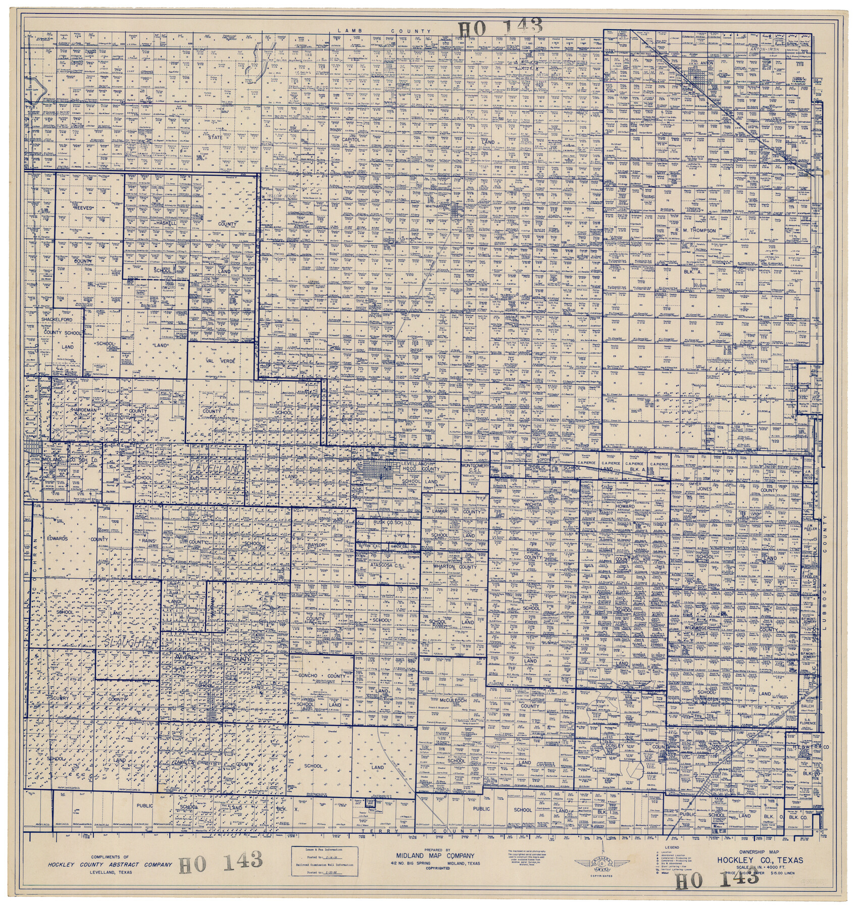
Ownership Map Hockley County, Texas
HO143
-
Map/Doc
92208
-
Collection
Twichell Survey Records
-
Counties
Hockley
-
Subjects
County
-
Height x Width
19.1 x 20.4 inches
48.5 x 51.8 cm
Part of: Twichell Survey Records
[Portions of Blocks K and K3]
![90775, [Portions of Blocks K and K3], Twichell Survey Records](https://historictexasmaps.com/wmedia_w700/maps/90775-1.tif.jpg)
Print $20.00
- Digital $50.00
[Portions of Blocks K and K3]
Size 20.3 x 13.1 inches
Map/Doc 90775
[County School Lands]
![91109, [County School Lands], Twichell Survey Records](https://historictexasmaps.com/wmedia_w700/maps/91109-1.tif.jpg)
Print $20.00
- Digital $50.00
[County School Lands]
Size 18.6 x 13.6 inches
Map/Doc 91109
[Blk. M, T. & P. Blocks 33-36, Townships 5N and 6N]
![90549, [Blk. M, T. & P. Blocks 33-36, Townships 5N and 6N], Twichell Survey Records](https://historictexasmaps.com/wmedia_w700/maps/90549-1.tif.jpg)
Print $20.00
- Digital $50.00
[Blk. M, T. & P. Blocks 33-36, Townships 5N and 6N]
Size 16.2 x 12.2 inches
Map/Doc 90549
Subdivision of the J. F. Carter Estate

Print $2.00
- Digital $50.00
Subdivision of the J. F. Carter Estate
Size 11.8 x 9.0 inches
Map/Doc 91279
[Lgs. 180-183, 196-198, 105-112, 678-680, 699-701, 141-143]
![90160, [Lgs. 180-183, 196-198, 105-112, 678-680, 699-701, 141-143], Twichell Survey Records](https://historictexasmaps.com/wmedia_w700/maps/90160-1.tif.jpg)
Print $20.00
- Digital $50.00
[Lgs. 180-183, 196-198, 105-112, 678-680, 699-701, 141-143]
1913
Size 28.6 x 19.1 inches
Map/Doc 90160
[John H. Tyler and Bob Reid Strip Surveys in Yates Field]
![91582, [John H. Tyler and Bob Reid Strip Surveys in Yates Field], Twichell Survey Records](https://historictexasmaps.com/wmedia_w700/maps/91582-1.tif.jpg)
Print $2.00
- Digital $50.00
[John H. Tyler and Bob Reid Strip Surveys in Yates Field]
Size 14.3 x 8.8 inches
Map/Doc 91582
Map Showing a Resurvey of Part of Blk. I, H. &. G. N. Ry. Co. Pecos County, Texas, following field notes copied from Jacob Kuechler's field book of his original survey made in October and November 1876

Print $20.00
- Digital $50.00
Map Showing a Resurvey of Part of Blk. I, H. &. G. N. Ry. Co. Pecos County, Texas, following field notes copied from Jacob Kuechler's field book of his original survey made in October and November 1876
1930
Size 19.7 x 14.8 inches
Map/Doc 91571
Richland Hills Addition to Muleshoe, Bailey County, Texas

Print $20.00
- Digital $50.00
Richland Hills Addition to Muleshoe, Bailey County, Texas
1957
Size 22.7 x 31.7 inches
Map/Doc 92461
Working Sketch Compiled From Original Field Notes Showing Surveys in Reagan and Irion Counties

Print $20.00
- Digital $50.00
Working Sketch Compiled From Original Field Notes Showing Surveys in Reagan and Irion Counties
Size 36.2 x 20.2 inches
Map/Doc 92331
![91836, [Block IT], Twichell Survey Records](https://historictexasmaps.com/wmedia_w700/maps/91836-1.tif.jpg)
[Block 1 and vicinity]
![90703, [Block 1 and vicinity], Twichell Survey Records](https://historictexasmaps.com/wmedia_w700/maps/90703-1.tif.jpg)
Print $20.00
- Digital $50.00
[Block 1 and vicinity]
Size 25.3 x 24.1 inches
Map/Doc 90703
Myrick Farm Lubbock & Hockley Counties

Print $20.00
- Digital $50.00
Myrick Farm Lubbock & Hockley Counties
Size 21.1 x 18.8 inches
Map/Doc 92831
You may also like


Map of the Pitchfork Ranch

Print $20.00
- Digital $50.00
Map of the Pitchfork Ranch
1915
Size 39.7 x 35.6 inches
Map/Doc 75827
Post Route Map of Texas (Inset 1: Dallas-Fort Worth Area; Inset 2: Texas Panhandle)

Print $40.00
- Digital $50.00
Post Route Map of Texas (Inset 1: Dallas-Fort Worth Area; Inset 2: Texas Panhandle)
1939
Size 56.9 x 39.3 inches
Map/Doc 93668
Bowie County Working Sketch 14

Print $20.00
- Digital $50.00
Bowie County Working Sketch 14
1959
Size 25.7 x 43.2 inches
Map/Doc 67418
Anton Independent School District Hockley and Lamb Counties, Texas

Print $20.00
- Digital $50.00
Anton Independent School District Hockley and Lamb Counties, Texas
Size 19.3 x 23.7 inches
Map/Doc 92215
Sabine County Working Sketch 11

Print $20.00
- Digital $50.00
Sabine County Working Sketch 11
1931
Size 30.9 x 34.0 inches
Map/Doc 63682
Brown County Working Sketch 20

Print $20.00
- Digital $50.00
Brown County Working Sketch 20
2011
Size 32.8 x 34.8 inches
Map/Doc 89999
Grayson County Sketch File 25

Print $6.00
- Digital $50.00
Grayson County Sketch File 25
Size 8.4 x 7.1 inches
Map/Doc 24507
Nolan County Rolled Sketch 4

Print $20.00
- Digital $50.00
Nolan County Rolled Sketch 4
1982
Size 21.7 x 25.2 inches
Map/Doc 6862
Abernathy Quadrangle

Print $20.00
- Digital $50.00
Abernathy Quadrangle
Size 17.6 x 21.4 inches
Map/Doc 92813
Hidalgo County Working Sketch 1

Print $20.00
- Digital $50.00
Hidalgo County Working Sketch 1
1939
Size 24.8 x 21.4 inches
Map/Doc 66178