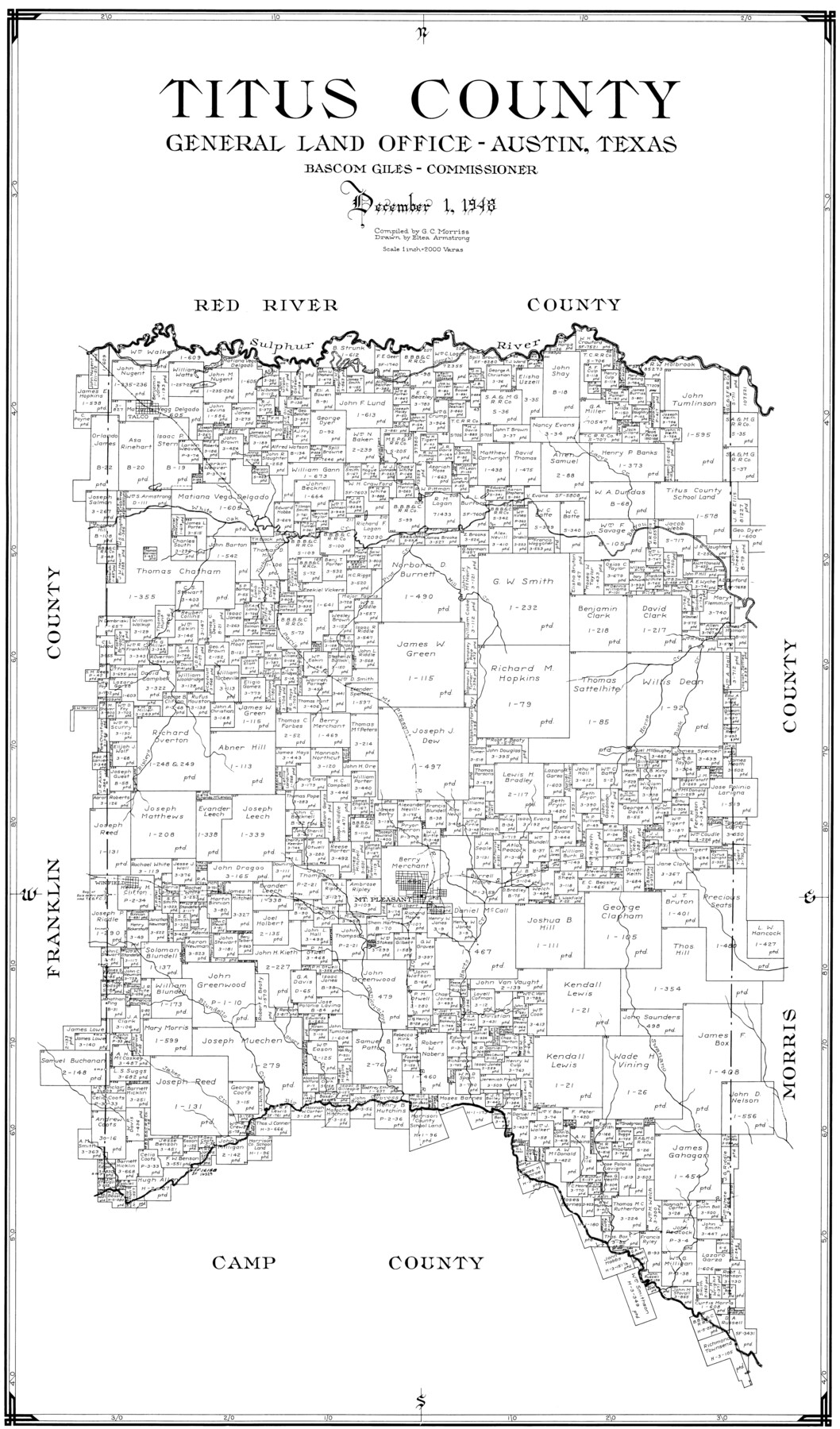
Titus County
-
Map/Doc
77436
-
Collection
General Map Collection
-
Object Dates
1948/12/1 (Creation Date)
-
People and Organizations
Eltea Armstrong (Draftsman)
G.C. Morriss (Compiler)
-
Counties
Titus
-
Subjects
County
-
Height x Width
39.0 x 22.9 inches
99.1 x 58.2 cm
Part of: General Map Collection
Map of Rains County

Print $20.00
- Digital $50.00
Map of Rains County
1873
Size 11.9 x 11.2 inches
Map/Doc 3973
Harris County Rolled Sketch 87A

Print $20.00
- Digital $50.00
Harris County Rolled Sketch 87A
Size 41.1 x 47.6 inches
Map/Doc 78250
Wilson County Working Sketch 9

Print $20.00
- Digital $50.00
Wilson County Working Sketch 9
1979
Size 31.6 x 33.0 inches
Map/Doc 72589
Denton County Working Sketch Graphic Index

Print $20.00
- Digital $50.00
Denton County Working Sketch Graphic Index
1947
Size 41.5 x 38.5 inches
Map/Doc 76521
Montgomery County Rolled Sketch 10A
Print $20.00
- Digital $50.00
Montgomery County Rolled Sketch 10A
Size 12.1 x 18.1 inches
Map/Doc 6800
Flight Mission No. BRE-3P, Frame 38, Nueces County

Print $20.00
- Digital $50.00
Flight Mission No. BRE-3P, Frame 38, Nueces County
1956
Size 18.5 x 22.4 inches
Map/Doc 86816
Edwards County Working Sketch 51

Print $20.00
- Digital $50.00
Edwards County Working Sketch 51
1950
Size 21.8 x 22.7 inches
Map/Doc 68927
Part of Matagorda Bay & Peninsula, Texas

Print $40.00
- Digital $50.00
Part of Matagorda Bay & Peninsula, Texas
1856
Size 31.8 x 51.4 inches
Map/Doc 69978
El Paso County Rolled Sketch 60

Print $20.00
- Digital $50.00
El Paso County Rolled Sketch 60
1992
Size 29.0 x 36.5 inches
Map/Doc 5852
Atascosa County Boundary File 6

Print $34.00
- Digital $50.00
Atascosa County Boundary File 6
Size 9.1 x 23.0 inches
Map/Doc 50205
Hall County Rolled Sketch 3

Print $20.00
- Digital $50.00
Hall County Rolled Sketch 3
1890
Size 12.6 x 22.6 inches
Map/Doc 6048
Trinity County Rolled Sketch 6

Print $20.00
- Digital $50.00
Trinity County Rolled Sketch 6
1999
Size 25.0 x 19.3 inches
Map/Doc 8053
You may also like
Uvalde County Working Sketch 13

Print $20.00
- Digital $50.00
Uvalde County Working Sketch 13
1943
Size 27.9 x 21.6 inches
Map/Doc 72083
Leon County Rolled Sketch 36

Print $20.00
- Digital $50.00
Leon County Rolled Sketch 36
Size 18.1 x 24.0 inches
Map/Doc 95352
Eastland County Working Sketch 57

Print $20.00
- Digital $50.00
Eastland County Working Sketch 57
1985
Size 21.7 x 21.8 inches
Map/Doc 68838
Edwards County Working Sketch 11

Print $20.00
- Digital $50.00
Edwards County Working Sketch 11
1922
Size 18.8 x 31.7 inches
Map/Doc 68887
Flight Mission No. BRA-7M, Frame 16, Jefferson County

Print $20.00
- Digital $50.00
Flight Mission No. BRA-7M, Frame 16, Jefferson County
1953
Size 18.5 x 22.2 inches
Map/Doc 85467
Flight Mission No. CRK-7P, Frame 82, Refugio County

Print $20.00
- Digital $50.00
Flight Mission No. CRK-7P, Frame 82, Refugio County
1956
Size 18.3 x 22.1 inches
Map/Doc 86953
Flight Mission No. CLL-4N, Frame 31, Willacy County

Print $20.00
- Digital $50.00
Flight Mission No. CLL-4N, Frame 31, Willacy County
1954
Size 18.4 x 22.1 inches
Map/Doc 87104
Flight Mission No. DQN-6K, Frame 93, Calhoun County

Print $20.00
- Digital $50.00
Flight Mission No. DQN-6K, Frame 93, Calhoun County
1953
Size 18.4 x 22.1 inches
Map/Doc 84453
Americae Sive Novi Orbis Nova Descriptio

Print $20.00
- Digital $50.00
Americae Sive Novi Orbis Nova Descriptio
1606
Size 16.4 x 22.3 inches
Map/Doc 93829
Schleicher County

Print $40.00
- Digital $50.00
Schleicher County
1898
Size 35.9 x 53.7 inches
Map/Doc 63027
Young County Working Sketch 15

Print $20.00
- Digital $50.00
Young County Working Sketch 15
1952
Size 13.7 x 18.0 inches
Map/Doc 62038
McMullen County Sketch File 11

Print $4.00
- Digital $50.00
McMullen County Sketch File 11
1876
Size 7.3 x 8.4 inches
Map/Doc 31355