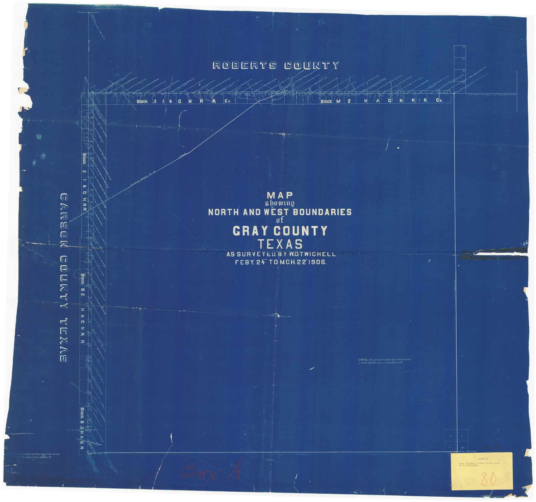
Map Showing North and West Boundaries of Gray County, Texas
90-9
-
Map/Doc
89942
-
Collection
Twichell Survey Records
-
Object Dates
3/22/1906 (Creation Date)
-
Counties
Gray Roberts Carson
-
Height x Width
42.4 x 38.9 inches
107.7 x 98.8 cm
Part of: Twichell Survey Records
[Jesse Folk and Surrounding Surveys]
![91087, [Jesse Folk and Surrounding Surveys], Twichell Survey Records](https://historictexasmaps.com/wmedia_w700/maps/91087-1.tif.jpg)
Print $20.00
- Digital $50.00
[Jesse Folk and Surrounding Surveys]
1922
Size 21.8 x 33.7 inches
Map/Doc 91087
[PSL Block B-19]
![93127, [PSL Block B-19], Twichell Survey Records](https://historictexasmaps.com/wmedia_w700/maps/93127-1.tif.jpg)
Print $40.00
- Digital $50.00
[PSL Block B-19]
Size 49.1 x 45.5 inches
Map/Doc 93127
Estate of John B. Googins' Land

Print $20.00
- Digital $50.00
Estate of John B. Googins' Land
Size 14.0 x 16.9 inches
Map/Doc 92849
[PSL Blocks Q, U, Y, Z, W]
![90436, [PSL Blocks Q, U, Y, Z, W], Twichell Survey Records](https://historictexasmaps.com/wmedia_w700/maps/90436-1.tif.jpg)
Print $20.00
- Digital $50.00
[PSL Blocks Q, U, Y, Z, W]
Size 6.6 x 21.7 inches
Map/Doc 90436
[Runnels County School Land and river surveys adjacent]
![91580, [Runnels County School Land and river surveys adjacent], Twichell Survey Records](https://historictexasmaps.com/wmedia_w700/maps/91580-1.tif.jpg)
Print $2.00
- Digital $50.00
[Runnels County School Land and river surveys adjacent]
1945
Size 13.5 x 8.7 inches
Map/Doc 91580
Working Sketch in Crockett County

Print $20.00
- Digital $50.00
Working Sketch in Crockett County
1927
Size 25.6 x 22.7 inches
Map/Doc 90304
Map of Survey made for Bascom Giles, General Land Commissioner, covering Bob Reid Mineral Application No. 35521

Print $20.00
- Digital $50.00
Map of Survey made for Bascom Giles, General Land Commissioner, covering Bob Reid Mineral Application No. 35521
1941
Size 26.5 x 19.1 inches
Map/Doc 91964
Map of Terry County

Print $20.00
- Digital $50.00
Map of Terry County
Size 34.0 x 34.2 inches
Map/Doc 92933
[Sections 155-162, Toyah Creek Irrigation Company and surrounding surveys]
![91037, [Sections 155-162, Toyah Creek Irrigation Company and surrounding surveys], Twichell Survey Records](https://historictexasmaps.com/wmedia_w700/maps/91037-1.tif.jpg)
Print $20.00
- Digital $50.00
[Sections 155-162, Toyah Creek Irrigation Company and surrounding surveys]
1916
Size 12.8 x 38.7 inches
Map/Doc 91037
[Blocks K3-K8, K11]
![90611, [Blocks K3-K8, K11], Twichell Survey Records](https://historictexasmaps.com/wmedia_w700/maps/90611-1.tif.jpg)
Print $20.00
- Digital $50.00
[Blocks K3-K8, K11]
Size 16.8 x 17.2 inches
Map/Doc 90611
W. C. Baze Subdivision a part of Tracts 25, 26, 27 and 28, Ross Addition to City of Idalou, Lubbock Co.

Print $20.00
- Digital $50.00
W. C. Baze Subdivision a part of Tracts 25, 26, 27 and 28, Ross Addition to City of Idalou, Lubbock Co.
1955
Size 9.2 x 18.9 inches
Map/Doc 92761
The Texas Co-Ordinate System, Title 86 Article 5300A.

Print $20.00
- Digital $50.00
The Texas Co-Ordinate System, Title 86 Article 5300A.
Size 30.8 x 28.4 inches
Map/Doc 92824
You may also like
Collingsworth County Sketch File 2

Print $20.00
- Digital $50.00
Collingsworth County Sketch File 2
1888
Size 24.3 x 31.3 inches
Map/Doc 11129
Map of Wood County Showing Location of the Texas and Pacific Railway

Print $20.00
- Digital $50.00
Map of Wood County Showing Location of the Texas and Pacific Railway
1872
Size 19.1 x 23.8 inches
Map/Doc 64135
Jim Hogg County Boundary File 1

Print $16.00
- Digital $50.00
Jim Hogg County Boundary File 1
Size 11.4 x 8.8 inches
Map/Doc 55519
Flight Mission No. DIX-6P, Frame 200, Aransas County

Print $20.00
- Digital $50.00
Flight Mission No. DIX-6P, Frame 200, Aransas County
1956
Size 19.0 x 22.7 inches
Map/Doc 83862
Garza County Rolled Sketch 14

Print $41.00
- Digital $50.00
Garza County Rolled Sketch 14
1913
Size 10.0 x 15.2 inches
Map/Doc 45234
Pecos County Sketch

Print $20.00
- Digital $50.00
Pecos County Sketch
1928
Size 38.6 x 21.6 inches
Map/Doc 91616
Martin County Sketch File 16

Print $2.00
- Digital $50.00
Martin County Sketch File 16
1996
Size 11.2 x 8.8 inches
Map/Doc 30676
Boundary Between the United States & Mexico Agreed Upon by the Joint Commission under the Treaty of Guadalupe Hidalgo

Print $4.00
- Digital $50.00
Boundary Between the United States & Mexico Agreed Upon by the Joint Commission under the Treaty of Guadalupe Hidalgo
1853
Size 24.5 x 18.4 inches
Map/Doc 65394
Donley County Sketch File 28

Print $40.00
- Digital $50.00
Donley County Sketch File 28
Size 25.7 x 9.1 inches
Map/Doc 21266
Brewster County Rolled Sketch 83

Print $20.00
- Digital $50.00
Brewster County Rolled Sketch 83
1946
Size 43.4 x 43.7 inches
Map/Doc 8495
Val Verde County Working Sketch 99

Print $20.00
- Digital $50.00
Val Verde County Working Sketch 99
1981
Size 17.2 x 22.6 inches
Map/Doc 72234
Kerr County Working Sketch 24

Print $20.00
- Digital $50.00
Kerr County Working Sketch 24
1966
Size 35.9 x 38.3 inches
Map/Doc 70055