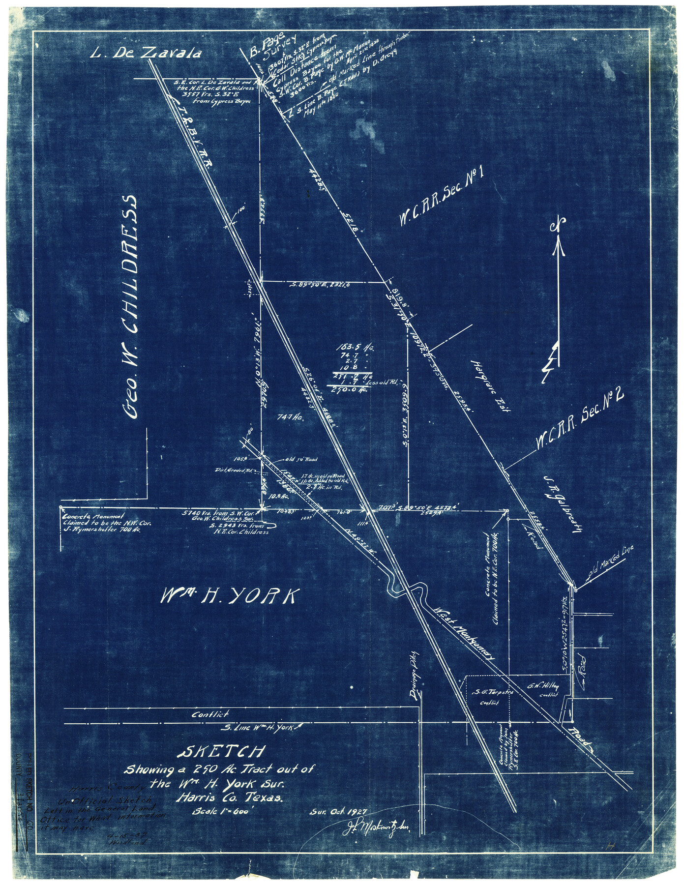
Harris County Rolled Sketch 60
Sketch showing a 250 ac. tract out of the Wm. H. York sur., Harris Co., Texas
-
Map/Doc
6106
-
Collection
General Map Collection
-
Object Dates
10/1927 (Creation Date)
-
People and Organizations
J.L. Moskowitz (Surveyor/Engineer)
-
Counties
Harris
-
Subjects
Surveying Rolled Sketch
-
Height x Width
27.4 x 21.3 inches
69.6 x 54.1 cm
-
Medium
blueprint/diazo
-
Scale
1" = 600 feet
Part of: General Map Collection
[Texas & Pacific Railway through Callahan County]
![64238, [Texas & Pacific Railway through Callahan County], General Map Collection](https://historictexasmaps.com/wmedia_w700/maps/64238.tif.jpg)
Print $20.00
- Digital $50.00
[Texas & Pacific Railway through Callahan County]
1918
Size 22.4 x 9.4 inches
Map/Doc 64238
Coleman County Sketch File 16

Print $4.00
- Digital $50.00
Coleman County Sketch File 16
1849
Size 9.6 x 8.3 inches
Map/Doc 18683
St. Louis, Brownsville & Mexico

Print $40.00
- Digital $50.00
St. Louis, Brownsville & Mexico
1906
Size 21.2 x 130.5 inches
Map/Doc 89280
Flight Mission No. BRE-3P, Frame 39, Nueces County

Print $20.00
- Digital $50.00
Flight Mission No. BRE-3P, Frame 39, Nueces County
1956
Size 18.6 x 22.5 inches
Map/Doc 86817
Texas, Corpus Christi Bay, Nueces Bay

Print $40.00
- Digital $50.00
Texas, Corpus Christi Bay, Nueces Bay
1934
Size 34.0 x 48.9 inches
Map/Doc 73458
Liberty County Sketch File 65

Print $4.00
- Digital $50.00
Liberty County Sketch File 65
1895
Size 11.0 x 8.7 inches
Map/Doc 30128
Upton County Sketch File 15

Print $20.00
- Digital $50.00
Upton County Sketch File 15
1927
Size 34.3 x 19.5 inches
Map/Doc 12513
Young Territory

Print $20.00
- Digital $50.00
Young Territory
1873
Size 29.2 x 29.9 inches
Map/Doc 1976
Sterling County Sketch File 26

Print $24.00
- Digital $50.00
Sterling County Sketch File 26
1989
Size 14.2 x 8.8 inches
Map/Doc 37194
Montgomery County Rolled Sketch 36

Print $20.00
- Digital $50.00
Montgomery County Rolled Sketch 36
1956
Size 25.8 x 23.6 inches
Map/Doc 6812
Travis County Working Sketch 25

Print $20.00
- Digital $50.00
Travis County Working Sketch 25
1948
Size 26.4 x 32.0 inches
Map/Doc 69409
Anderson County Sketch File 12

Print $6.00
- Digital $50.00
Anderson County Sketch File 12
1852
Size 13.7 x 8.3 inches
Map/Doc 12771
You may also like
Hopkins County Rolled Sketch 28

Print $20.00
- Digital $50.00
Hopkins County Rolled Sketch 28
Size 25.3 x 19.9 inches
Map/Doc 6225
Flight Mission No. DIX-6P, Frame 201, Aransas County

Print $20.00
- Digital $50.00
Flight Mission No. DIX-6P, Frame 201, Aransas County
1956
Size 18.9 x 22.8 inches
Map/Doc 83863
Tarrant County Sketch File 19

Print $4.00
- Digital $50.00
Tarrant County Sketch File 19
Size 9.7 x 8.1 inches
Map/Doc 37721
Map of Titus County

Print $20.00
- Digital $50.00
Map of Titus County
1857
Size 23.8 x 34.3 inches
Map/Doc 4857
Harrison County Sketch File 4

Print $4.00
- Digital $50.00
Harrison County Sketch File 4
Size 9.0 x 8.0 inches
Map/Doc 26040
Stephens County Sketch File B

Print $9.00
- Digital $50.00
Stephens County Sketch File B
1919
Size 13.2 x 8.7 inches
Map/Doc 37070
Brooks County Rolled Sketch 17

Print $20.00
- Digital $50.00
Brooks County Rolled Sketch 17
1941
Size 30.8 x 36.5 inches
Map/Doc 8532
[Lgs. 180-183, 196-198, 105-112, 678-680, 699-701, 141-143]
![90155, [Lgs. 180-183, 196-198, 105-112, 678-680, 699-701, 141-143], Twichell Survey Records](https://historictexasmaps.com/wmedia_w700/maps/90155-1.tif.jpg)
Print $2.00
- Digital $50.00
[Lgs. 180-183, 196-198, 105-112, 678-680, 699-701, 141-143]
1913
Size 9.9 x 6.0 inches
Map/Doc 90155
Bee County Working Sketch 23

Print $20.00
- Digital $50.00
Bee County Working Sketch 23
1985
Size 32.6 x 31.1 inches
Map/Doc 67273
Harris County Working Sketch 17

Print $20.00
- Digital $50.00
Harris County Working Sketch 17
1919
Size 40.0 x 41.6 inches
Map/Doc 65909
Loving County Working Sketch 8

Print $40.00
- Digital $50.00
Loving County Working Sketch 8
1952
Size 21.9 x 56.6 inches
Map/Doc 70640
[Blocks JK, JK4, JD, A1, and A2]
![90748, [Blocks JK, JK4, JD, A1, and A2], Twichell Survey Records](https://historictexasmaps.com/wmedia_w700/maps/90748-1.tif.jpg)
Print $20.00
- Digital $50.00
[Blocks JK, JK4, JD, A1, and A2]
Size 12.5 x 28.8 inches
Map/Doc 90748