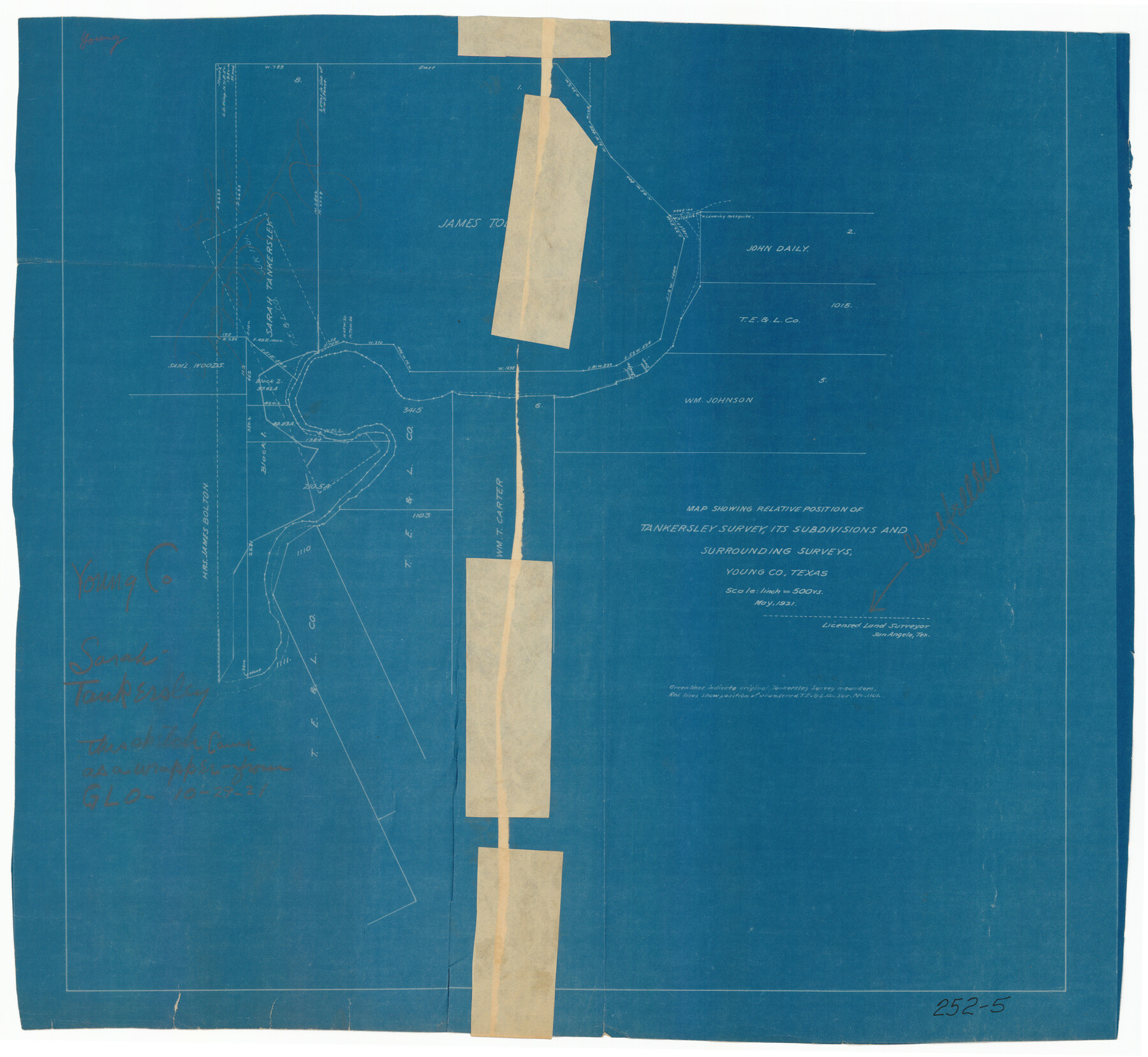
Map Showing Relative Position of Tankersley Survey, its Subdivisions and Surrounding Surveys, Young County, Texas
252-5
-
Map/Doc
92020
-
Collection
Twichell Survey Records
-
Object Dates
5/1921 (Creation Date)
-
People and Organizations
Goodfellow (Surveyor/Engineer)
-
Counties
Young
-
Height x Width
22.3 x 20.3 inches
56.6 x 51.6 cm
Part of: Twichell Survey Records
Sketch in Floyd County

Print $20.00
- Digital $50.00
Sketch in Floyd County
1911
Size 25.3 x 41.8 inches
Map/Doc 90916
[Area north of League 1, Morris County School Land]
![90354, [Area north of League 1, Morris County School Land], Twichell Survey Records](https://historictexasmaps.com/wmedia_w700/maps/90354-1.tif.jpg)
Print $3.00
- Digital $50.00
[Area north of League 1, Morris County School Land]
1912
Size 11.4 x 9.6 inches
Map/Doc 90354
[Portions of Blocks T1, B, and T]
![90950, [Portions of Blocks T1, B, and T], Twichell Survey Records](https://historictexasmaps.com/wmedia_w700/maps/90950-1.tif.jpg)
Print $2.00
- Digital $50.00
[Portions of Blocks T1, B, and T]
1910
Size 13.8 x 4.3 inches
Map/Doc 90950

[Leagues 445, 465-468, Block B, Gregg County School Land Leagues 1 and 2]
![90532, [Leagues 445, 465-468, Block B, Gregg County School Land Leagues 1 and 2], Twichell Survey Records](https://historictexasmaps.com/wmedia_w700/maps/90532-1.tif.jpg)
Print $2.00
- Digital $50.00
[Leagues 445, 465-468, Block B, Gregg County School Land Leagues 1 and 2]
1902
Size 9.0 x 9.9 inches
Map/Doc 90532
Walter Butler Irrigated Farm

Print $20.00
- Digital $50.00
Walter Butler Irrigated Farm
Size 24.4 x 17.7 inches
Map/Doc 92318
Map of a part of Block One, I. & G. N. RR. Co. and the Pecos River

Print $20.00
- Digital $50.00
Map of a part of Block One, I. & G. N. RR. Co. and the Pecos River
1927
Size 34.2 x 17.4 inches
Map/Doc 90320
[H. & T. C. 46, Sections 79- 84]
![91262, [H. & T. C. 46, Sections 79- 84], Twichell Survey Records](https://historictexasmaps.com/wmedia_w700/maps/91262-1.tif.jpg)
Print $20.00
- Digital $50.00
[H. & T. C. 46, Sections 79- 84]
Size 27.3 x 32.6 inches
Map/Doc 91262
University of Texas System University Lands

Print $20.00
- Digital $50.00
University of Texas System University Lands
1938
Size 23.4 x 17.9 inches
Map/Doc 93243
[Blks. B9, J, D19, John Walker]
![90480, [Blks. B9, J, D19, John Walker], Twichell Survey Records](https://historictexasmaps.com/wmedia_w700/maps/90480-1.tif.jpg)
Print $20.00
- Digital $50.00
[Blks. B9, J, D19, John Walker]
Size 28.6 x 15.9 inches
Map/Doc 90480
[Map showing Sanborn's Addition and Denver Heights Addition]
![91829, [Map showing Sanborn's Addition and Denver Heights Addition], Twichell Survey Records](https://historictexasmaps.com/wmedia_w700/maps/91829-1.tif.jpg)
Print $20.00
- Digital $50.00
[Map showing Sanborn's Addition and Denver Heights Addition]
Size 22.5 x 38.9 inches
Map/Doc 91829
[Sections 1035-1038, E. B. Logan survey and vicinity]
![90342, [Sections 1035-1038, E. B. Logan survey and vicinity], Twichell Survey Records](https://historictexasmaps.com/wmedia_w700/maps/90342-1.tif.jpg)
Print $3.00
- Digital $50.00
[Sections 1035-1038, E. B. Logan survey and vicinity]
Size 15.0 x 10.6 inches
Map/Doc 90342
You may also like
[Sketch of surveys in the vicinity of sections 171 and 172 along Pedernales]
![91882, [Sketch of surveys in the vicinity of sections 171 and 172 along Pedernales], Twichell Survey Records](https://historictexasmaps.com/wmedia_w700/maps/91882-1.tif.jpg)
Print $20.00
- Digital $50.00
[Sketch of surveys in the vicinity of sections 171 and 172 along Pedernales]
Size 17.2 x 12.9 inches
Map/Doc 91882
Webb County Sketch File 5a

Print $8.00
- Digital $50.00
Webb County Sketch File 5a
1877
Size 12.9 x 8.2 inches
Map/Doc 39729

Sketch of Texas with the boundaries of Mexican States as shown on General Austin's map of Texas

Print $20.00
Sketch of Texas with the boundaries of Mexican States as shown on General Austin's map of Texas
1839
Size 20.9 x 16.1 inches
Map/Doc 93574
McMullen County Sketch File 17

Print $4.00
- Digital $50.00
McMullen County Sketch File 17
Size 8.0 x 10.0 inches
Map/Doc 31369
Flight Mission No. BRE-2P, Frame 62, Nueces County

Print $20.00
- Digital $50.00
Flight Mission No. BRE-2P, Frame 62, Nueces County
1956
Size 18.3 x 22.5 inches
Map/Doc 86757
Map of Jack County

Print $20.00
- Digital $50.00
Map of Jack County
1895
Size 47.6 x 38.0 inches
Map/Doc 4988
Zavala County Working Sketch 27

Print $20.00
- Digital $50.00
Zavala County Working Sketch 27
1990
Size 22.3 x 27.5 inches
Map/Doc 62102

Foard County Sketch File 21

Print $14.00
- Digital $50.00
Foard County Sketch File 21
Size 13.1 x 8.6 inches
Map/Doc 22839
Val Verde County Rolled Sketch 10

Print $20.00
- Digital $50.00
Val Verde County Rolled Sketch 10
Size 22.9 x 27.8 inches
Map/Doc 8108
Flight Mission No. CRC-3R, Frame 9, Chambers County

Print $20.00
- Digital $50.00
Flight Mission No. CRC-3R, Frame 9, Chambers County
1956
Size 18.7 x 22.4 inches
Map/Doc 84783