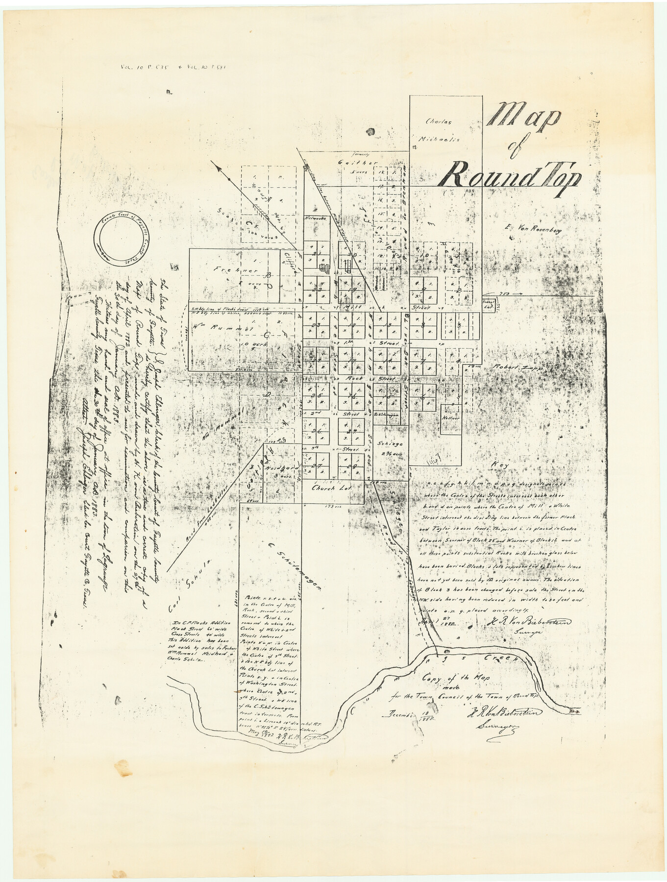
Map of Round Top
-
Map/Doc
94751
-
Collection
Non-GLO Digital Images
-
Object Dates
1882/4/27 (Creation Date)
1882/12/18 (Copy/Tracing Date)
-
People and Organizations
H.R. Von Bieberstein (Surveyor/Engineer)
-
Counties
Fayette
-
Subjects
City
-
Height x Width
24.4 x 18.4 inches
62.0 x 46.7 cm
-
Medium
digital image
-
Comments
Image provided by JT Koenig in June 2018.
Part of: Non-GLO Digital Images

Mapa de Texas con partes de los Estados Adyacentes

Mapa de Texas con partes de los Estados Adyacentes
1832
Size 6.8 x 5.7 inches
Map/Doc 94560
[Movements & Objectives of the 143rd & 144th Infantry on October 12-13, 1918, Appendix E, No.1]
![94126, [Movements & Objectives of the 143rd & 144th Infantry on October 12-13, 1918, Appendix E, No.1], Non-GLO Digital Images](https://historictexasmaps.com/wmedia_w700/maps/94126-1.tif.jpg)
Print $20.00
[Movements & Objectives of the 143rd & 144th Infantry on October 12-13, 1918, Appendix E, No.1]
1918
Size 22.5 x 20.0 inches
Map/Doc 94126
Map of Texas from the most recent authorities

Print $20.00
Map of Texas from the most recent authorities
1845
Size 13.5 x 17.1 inches
Map/Doc 94574

Perspective Map of the City of Laredo, Texas, the Gateway to and from Mexico

Print $20.00
Perspective Map of the City of Laredo, Texas, the Gateway to and from Mexico
1892
Size 22.1 x 34.2 inches
Map/Doc 89098
Map of the City of Austin

Print $20.00
Map of the City of Austin
1910
Size 24.0 x 18.0 inches
Map/Doc 90071
Map of Texas and part of New Mexico

Print $20.00
Map of Texas and part of New Mexico
1857
Size 17.4 x 23.1 inches
Map/Doc 95284
[Movements & Objectives of the 143rd & 144th Infantry on October 12-13, 1918] - Verso
![94136, [Movements & Objectives of the 143rd & 144th Infantry on October 12-13, 1918] - Verso, Non-GLO Digital Images](https://historictexasmaps.com/wmedia_w700/maps/94136-1.tif.jpg)
Print $20.00
[Movements & Objectives of the 143rd & 144th Infantry on October 12-13, 1918] - Verso
1918
Size 42.4 x 30.0 inches
Map/Doc 94136
Bird's Eye View of Abilene, Taylor County, Texas

Print $20.00
Bird's Eye View of Abilene, Taylor County, Texas
1883
Size 23.6 x 30.7 inches
Map/Doc 89071
[Movements & Objectives of the 143rd & 144th Infantry & 133rd Machine Gun Battalion on October 8-9, 1918, Appendix E, No. 4]
![94133, [Movements & Objectives of the 143rd & 144th Infantry & 133rd Machine Gun Battalion on October 8-9, 1918, Appendix E, No. 4], Non-GLO Digital Images](https://historictexasmaps.com/wmedia_w700/maps/94133-1.tif.jpg)
Print $20.00
[Movements & Objectives of the 143rd & 144th Infantry & 133rd Machine Gun Battalion on October 8-9, 1918, Appendix E, No. 4]
1918
Size 21.5 x 20.2 inches
Map/Doc 94133

You may also like
Presidio County Rolled Sketch 78

Print $20.00
- Digital $50.00
Presidio County Rolled Sketch 78
1941
Size 32.4 x 39.2 inches
Map/Doc 7364
Shelby County Working Sketch 25

Print $20.00
- Digital $50.00
Shelby County Working Sketch 25
1948
Size 23.5 x 36.2 inches
Map/Doc 63879

Hardeman County Sketch File 14a

Print $20.00
- Digital $50.00
Hardeman County Sketch File 14a
Size 24.4 x 29.0 inches
Map/Doc 11626
From Citizens of Shelby and Red River Counties Living East of the Sabine River and Southwest of the Sulphur Fork of Red River for the Creation of a New County to be Called Green, March 11, 1837/April 1, 1837

Print $20.00
From Citizens of Shelby and Red River Counties Living East of the Sabine River and Southwest of the Sulphur Fork of Red River for the Creation of a New County to be Called Green, March 11, 1837/April 1, 1837
2020
Size 24.3 x 21.7 inches
Map/Doc 96373
Clay County Sketch File 12

Print $4.00
- Digital $50.00
Clay County Sketch File 12
1873
Size 13.0 x 8.2 inches
Map/Doc 18411
Orange County Rolled Sketch 20

Print $40.00
- Digital $50.00
Orange County Rolled Sketch 20
1947
Size 35.2 x 64.3 inches
Map/Doc 9645
Map of San Gabriel & Lampassas [sic] Surveys
![58, Map of San Gabriel & Lampassas [sic] Surveys, General Map Collection](https://historictexasmaps.com/wmedia_w700/maps/58.tif.jpg)
Print $20.00
- Digital $50.00
Map of San Gabriel & Lampassas [sic] Surveys
1841
Size 29.0 x 20.0 inches
Map/Doc 58
Jack County Working Sketch 11

Print $20.00
- Digital $50.00
Jack County Working Sketch 11
1959
Size 23.9 x 23.4 inches
Map/Doc 66437
Map of Texas. The Proposed Reoccupation of the Rio Grande -- Its Importance to the Union

Print $20.00
Map of Texas. The Proposed Reoccupation of the Rio Grande -- Its Importance to the Union
1965
Size 14.1 x 8.6 inches
Map/Doc 76264
Baylor County Boundary File 2

Print $44.00
- Digital $50.00
Baylor County Boundary File 2
Size 8.9 x 25.9 inches
Map/Doc 50359
Intracoastal Waterway in Texas - Corpus Christi to Point Isabel including Arroyo Colorado to Mo. Pac. R.R. Bridge Near Harlingen

Print $20.00
- Digital $50.00
Intracoastal Waterway in Texas - Corpus Christi to Point Isabel including Arroyo Colorado to Mo. Pac. R.R. Bridge Near Harlingen
1933
Size 40.9 x 27.8 inches
Map/Doc 61874