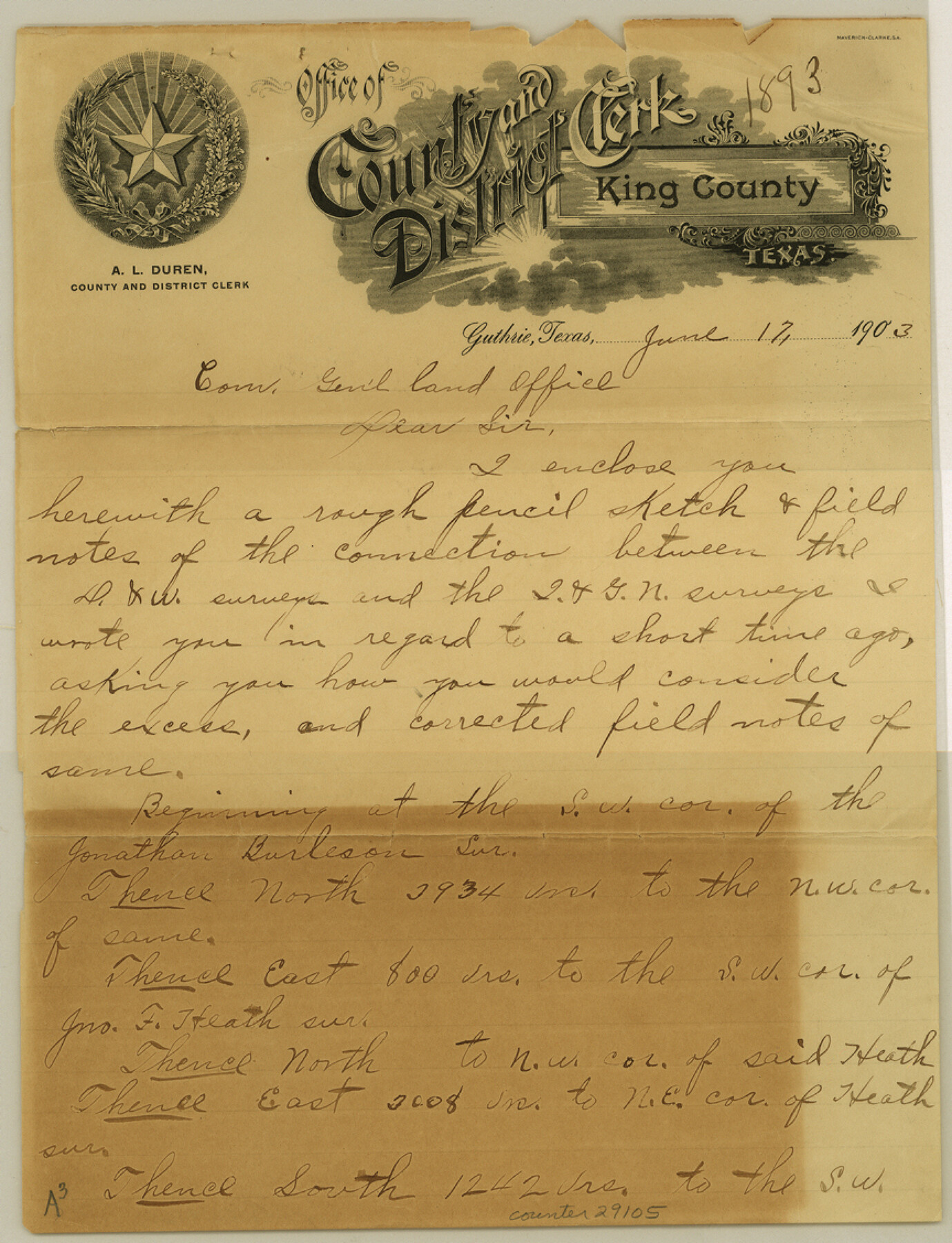
King County Sketch File 12
[Report and sketch of surveys on north line of county]
-
Map/Doc
29105
-
Collection
General Map Collection
-
Object Dates
6/17/1903 (Creation Date)
6/17/1903 (Correspondence Date)
-
People and Organizations
G.W. Moore (Surveyor/Engineer)
-
Counties
King Cottle
-
Subjects
Surveying Sketch File
-
Height x Width
11.3 x 8.6 inches
28.7 x 21.8 cm
-
Medium
paper, manuscript
Part of: General Map Collection
Hudspeth County Rolled Sketch 66

Print $20.00
- Digital $50.00
Hudspeth County Rolled Sketch 66
1973
Size 12.1 x 19.9 inches
Map/Doc 6260
Angelina County Sketch File 6

Print $4.00
- Digital $50.00
Angelina County Sketch File 6
1856
Size 8.1 x 8.2 inches
Map/Doc 12933
Right of Way and Track Map, the Missouri, Kansas and Texas Ry. of Texas operated by the Missouri, Kansas and Texas Ry. of Texas, Henrietta Division

Print $40.00
- Digital $50.00
Right of Way and Track Map, the Missouri, Kansas and Texas Ry. of Texas operated by the Missouri, Kansas and Texas Ry. of Texas, Henrietta Division
1918
Size 25.1 x 56.4 inches
Map/Doc 64065
West Part Presidio Co.

Print $20.00
- Digital $50.00
West Part Presidio Co.
1974
Size 42.1 x 33.3 inches
Map/Doc 73267
Brewster County Rolled Sketch 74

Print $20.00
- Digital $50.00
Brewster County Rolled Sketch 74
1941
Size 22.8 x 15.8 inches
Map/Doc 5240
Flight Mission No. CRE-2R, Frame 162, Jackson County

Print $20.00
- Digital $50.00
Flight Mission No. CRE-2R, Frame 162, Jackson County
1956
Size 18.5 x 22.3 inches
Map/Doc 85373
Hardeman County Sketch File 26

Print $40.00
- Digital $50.00
Hardeman County Sketch File 26
Size 16.3 x 13.2 inches
Map/Doc 25037
San Patricio County Working Sketch 9

Print $40.00
- Digital $50.00
San Patricio County Working Sketch 9
1937
Size 52.8 x 44.0 inches
Map/Doc 63771
Loving County

Print $20.00
- Digital $50.00
Loving County
1932
Size 32.4 x 44.0 inches
Map/Doc 77358
Medina County Rolled Sketch 4

Print $20.00
- Digital $50.00
Medina County Rolled Sketch 4
1943
Size 20.2 x 26.4 inches
Map/Doc 6740
Randall County Boundary File 5

Print $14.00
- Digital $50.00
Randall County Boundary File 5
Size 8.9 x 7.8 inches
Map/Doc 58134
Stonewall County Sketch File 17

Print $6.00
- Digital $50.00
Stonewall County Sketch File 17
1902
Size 16.5 x 10.6 inches
Map/Doc 37274
You may also like
Map of Galveston, Turtle & East Bays & portions of the Gulf of Mexico in Chambers & Galveston Counties, Texas showing subdivision for mineral development

Print $40.00
- Digital $50.00
Map of Galveston, Turtle & East Bays & portions of the Gulf of Mexico in Chambers & Galveston Counties, Texas showing subdivision for mineral development
1945
Size 46.3 x 52.8 inches
Map/Doc 3068

Bandera County Working Sketch 21

Print $20.00
- Digital $50.00
Bandera County Working Sketch 21
1948
Size 21.1 x 16.7 inches
Map/Doc 67617
Comal County Sketch File 12

Print $4.00
- Digital $50.00
Comal County Sketch File 12
Size 8.4 x 11.3 inches
Map/Doc 19024
Amistad International Reservoir on Rio Grande 100

Print $20.00
- Digital $50.00
Amistad International Reservoir on Rio Grande 100
1950
Size 28.5 x 40.8 inches
Map/Doc 75531
Montague County Working Sketch 39

Print $20.00
- Digital $50.00
Montague County Working Sketch 39
1994
Size 34.4 x 45.0 inches
Map/Doc 71105
Brewster County Sketch File 52

Print $16.00
- Digital $50.00
Brewster County Sketch File 52
1996
Size 14.1 x 8.8 inches
Map/Doc 16357
Victoria County Working Sketch 6

Print $20.00
- Digital $50.00
Victoria County Working Sketch 6
1944
Size 36.3 x 33.9 inches
Map/Doc 72276
Texas and part of Mexico & the United States, showing the route of the first Santa Fe Expedition

Print $20.00
- Digital $50.00
Texas and part of Mexico & the United States, showing the route of the first Santa Fe Expedition
1844
Size 18.1 x 13.2 inches
Map/Doc 94035
Flight Mission No. CGI-3N, Frame 132, Cameron County

Print $20.00
- Digital $50.00
Flight Mission No. CGI-3N, Frame 132, Cameron County
1954
Size 18.4 x 22.2 inches
Map/Doc 84605
Wayland Crossing Sheet Robertson, Limestone and Leon Counties, Navasota River

Print $20.00
- Digital $50.00
Wayland Crossing Sheet Robertson, Limestone and Leon Counties, Navasota River
1934
Size 43.9 x 40.9 inches
Map/Doc 65072
Aransas County Aerial Photograph Index Sheet 1

Print $20.00
- Digital $50.00
Aransas County Aerial Photograph Index Sheet 1
1957
Size 22.9 x 18.2 inches
Map/Doc 83659