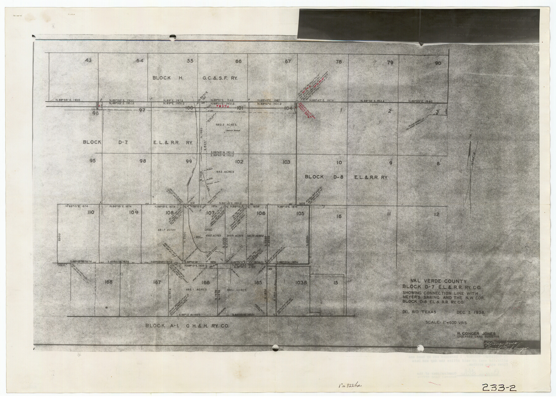
Val Verde County, Texas, Block D-7, E. L. & R. R. Ry. showing connecting line with Meyer's Spring and the N.W. corner Block D-8, E. L. & R. R. Ry. Co.
233-2
-
Map/Doc
91949
-
Collection
Twichell Survey Records
-
Object Dates
12/7/1938 (Creation Date)
-
People and Organizations
H. Conger Jones (Surveyor/Engineer)
-
Counties
Val Verde Terrell
-
Height x Width
26.7 x 18.7 inches
67.8 x 47.5 cm
Part of: Twichell Survey Records
G & H Blocks, Gaines County, Texas Resurvey

Print $40.00
- Digital $50.00
G & H Blocks, Gaines County, Texas Resurvey
1915
Size 58.1 x 33.7 inches
Map/Doc 89667
France Baker Farm

Print $3.00
- Digital $50.00
France Baker Farm
Size 9.5 x 12.0 inches
Map/Doc 92332
[Leagues 247, 320, and 321]
![91290, [Leagues 247, 320, and 321], Twichell Survey Records](https://historictexasmaps.com/wmedia_w700/maps/91290-1.tif.jpg)
Print $2.00
- Digital $50.00
[Leagues 247, 320, and 321]
Size 7.8 x 14.5 inches
Map/Doc 91290
Map of Public Roads in Terry County, Texas

Print $2.00
- Digital $50.00
Map of Public Roads in Terry County, Texas
1951
Size 9.1 x 11.6 inches
Map/Doc 91937
[Sections 69-84 Block 47 and part of Block 3]
![91795, [Sections 69-84 Block 47 and part of Block 3], Twichell Survey Records](https://historictexasmaps.com/wmedia_w700/maps/91795-1.tif.jpg)
Print $2.00
- Digital $50.00
[Sections 69-84 Block 47 and part of Block 3]
Size 14.3 x 8.9 inches
Map/Doc 91795
King County Survey

Print $20.00
- Digital $50.00
King County Survey
1916
Size 25.6 x 30.5 inches
Map/Doc 91021
[Texas Boundary Line]
![92082, [Texas Boundary Line], Twichell Survey Records](https://historictexasmaps.com/wmedia_w700/maps/92082-1.tif.jpg)
Print $20.00
- Digital $50.00
[Texas Boundary Line]
Size 21.6 x 12.2 inches
Map/Doc 92082
[County School Land Leagues]
![90279, [County School Land Leagues], Twichell Survey Records](https://historictexasmaps.com/wmedia_w700/maps/90279-1.tif.jpg)
Print $20.00
- Digital $50.00
[County School Land Leagues]
1913
Size 21.1 x 27.7 inches
Map/Doc 90279
[Tie line from Northeast Block 36, Township 5N to Northwest corner Block M]
![90559, [Tie line from Northeast Block 36, Township 5N to Northwest corner Block M], Twichell Survey Records](https://historictexasmaps.com/wmedia_w700/maps/90559-1.tif.jpg)
Print $20.00
- Digital $50.00
[Tie line from Northeast Block 36, Township 5N to Northwest corner Block M]
Size 22.3 x 10.3 inches
Map/Doc 90559
Section M, Tech Memorial Park, Inc.

Print $2.00
- Digital $50.00
Section M, Tech Memorial Park, Inc.
1950
Size 7.6 x 11.8 inches
Map/Doc 92271
Famous Heights Park Addition, Map Showing Proposed Park and Plan of Subdividing Famous Heights Plus Park, Addition to the city of Amarillo, Texas

Print $40.00
- Digital $50.00
Famous Heights Park Addition, Map Showing Proposed Park and Plan of Subdividing Famous Heights Plus Park, Addition to the city of Amarillo, Texas
1907
Size 62.5 x 37.4 inches
Map/Doc 93117
[Sketch of surveys around W.T. Brewer]
![89926, [Sketch of surveys around W.T. Brewer], Twichell Survey Records](https://historictexasmaps.com/wmedia_w700/maps/89926-1.tif.jpg)
Print $40.00
- Digital $50.00
[Sketch of surveys around W.T. Brewer]
Size 37.0 x 48.7 inches
Map/Doc 89926
You may also like
Galveston County NRC Article 33.136 Location Key Sheet

Print $20.00
- Digital $50.00
Galveston County NRC Article 33.136 Location Key Sheet
1974
Size 27.0 x 23.0 inches
Map/Doc 77025
Brewster County Working Sketch 42

Print $20.00
- Digital $50.00
Brewster County Working Sketch 42
1947
Size 39.9 x 31.0 inches
Map/Doc 67576
Henderson County Working Sketch 3

Print $20.00
- Digital $50.00
Henderson County Working Sketch 3
Size 28.5 x 38.3 inches
Map/Doc 66136
[Surveys in the Travis District along the Colorado River]
![117, [Surveys in the Travis District along the Colorado River], General Map Collection](https://historictexasmaps.com/wmedia_w700/maps/117.tif.jpg)
Print $2.00
- Digital $50.00
[Surveys in the Travis District along the Colorado River]
1840
Size 8.9 x 6.3 inches
Map/Doc 117
Culberson County Sketch File 22

Print $6.00
- Digital $50.00
Culberson County Sketch File 22
1934
Size 11.8 x 8.8 inches
Map/Doc 20234
Pecos County Rolled Sketch 137

Print $20.00
- Digital $50.00
Pecos County Rolled Sketch 137
Size 20.1 x 15.0 inches
Map/Doc 7273
Glasscock County Sketch File 8

Print $6.00
- Digital $50.00
Glasscock County Sketch File 8
Size 9.5 x 14.9 inches
Map/Doc 24168

Gray County Working Sketch 2

Print $20.00
- Digital $50.00
Gray County Working Sketch 2
1957
Size 26.7 x 27.8 inches
Map/Doc 63233
Moore County Sketch File 13

Print $24.00
- Digital $50.00
Moore County Sketch File 13
1919
Size 7.0 x 8.7 inches
Map/Doc 31949
General Highway Map, King County, Texas

Print $20.00
General Highway Map, King County, Texas
1940
Size 18.3 x 24.8 inches
Map/Doc 79161
Harris County Sketch File E

Print $4.00
- Digital $50.00
Harris County Sketch File E
1860
Size 7.6 x 12.1 inches
Map/Doc 25315