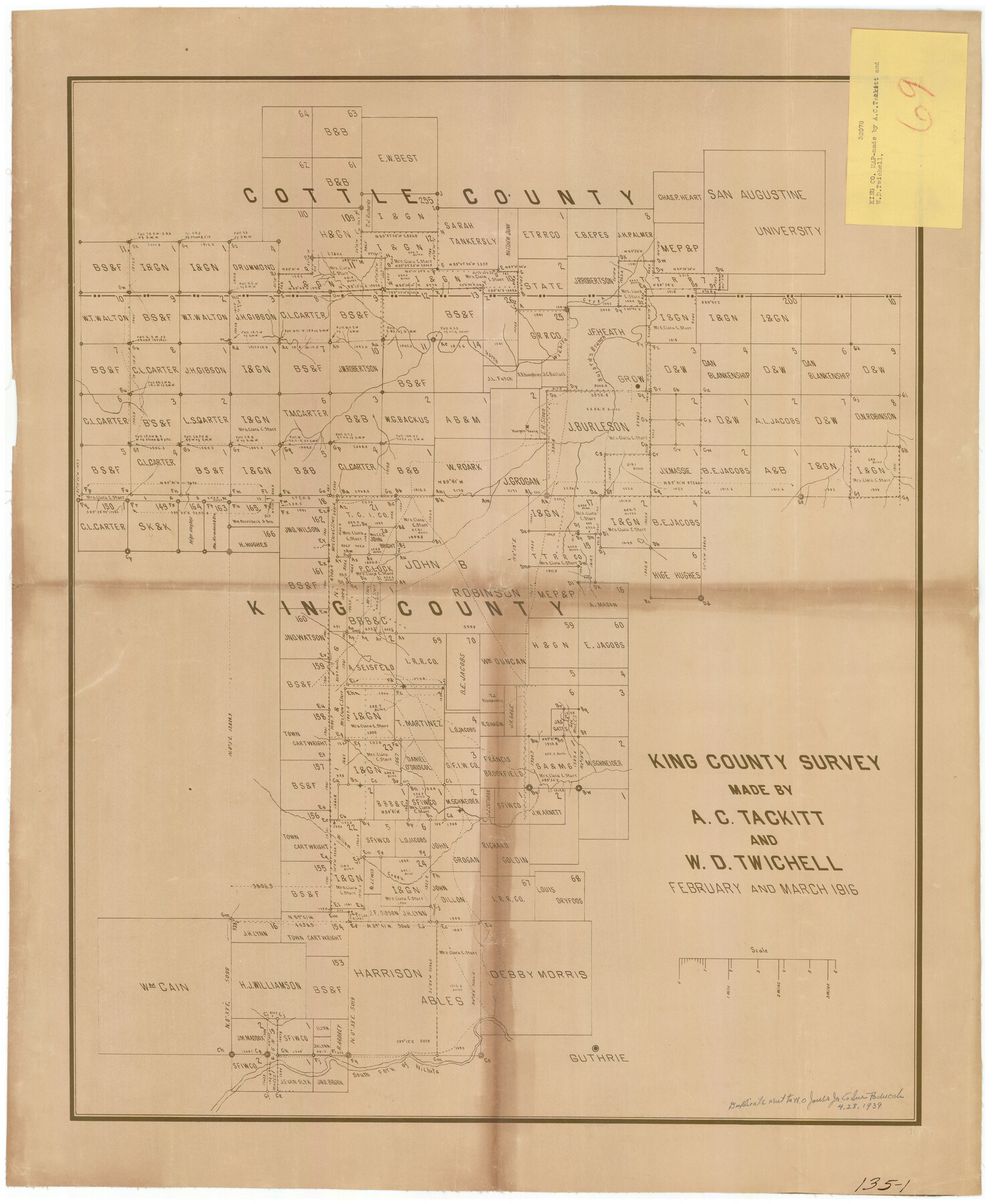
King County Survey
135-1
-
Map/Doc
91021
-
Collection
Twichell Survey Records
-
Object Dates
2/1916 (Creation Date)
-
People and Organizations
A.C. Tackitt (Surveyor/Engineer)
-
Counties
King
-
Height x Width
25.6 x 30.5 inches
65.0 x 77.5 cm
Part of: Twichell Survey Records
[Blocks M8, M9, M11, W1, RC, M13, M15 and A]
![91928, [Blocks M8, M9, M11, W1, RC, M13, M15 and A], Twichell Survey Records](https://historictexasmaps.com/wmedia_w700/maps/91928-1.tif.jpg)
Print $20.00
- Digital $50.00
[Blocks M8, M9, M11, W1, RC, M13, M15 and A]
Size 17.1 x 34.2 inches
Map/Doc 91928
[I. & G. N. Block 1]
![93028, [I. & G. N. Block 1], Twichell Survey Records](https://historictexasmaps.com/wmedia_w700/maps/93028-1.tif.jpg)
Print $20.00
- Digital $50.00
[I. & G. N. Block 1]
Size 42.3 x 32.8 inches
Map/Doc 93028
[Township 2 North, Blocks 32 and 33]
![91212, [Township 2 North, Blocks 32 and 33], Twichell Survey Records](https://historictexasmaps.com/wmedia_w700/maps/91212-1.tif.jpg)
Print $3.00
- Digital $50.00
[Township 2 North, Blocks 32 and 33]
Size 11.8 x 10.8 inches
Map/Doc 91212
Sketch in Bailey County

Print $20.00
- Digital $50.00
Sketch in Bailey County
Size 15.6 x 33.5 inches
Map/Doc 92476
[Township 3 North, Block 32]
![91207, [Township 3 North, Block 32], Twichell Survey Records](https://historictexasmaps.com/wmedia_w700/maps/91207-1.tif.jpg)
Print $20.00
- Digital $50.00
[Township 3 North, Block 32]
Size 14.4 x 17.8 inches
Map/Doc 91207
![92467, [Muleshoe], Twichell Survey Records](https://historictexasmaps.com/wmedia_w700/maps/92467-1.tif.jpg)
[B. S. & F. Blocks 1 and 6, A. B. & M. Block 2 and surrounding surveys and blocks]
![91785, [B. S. & F. Blocks 1 and 6, A. B. & M. Block 2 and surrounding surveys and blocks], Twichell Survey Records](https://historictexasmaps.com/wmedia_w700/maps/91785-1.tif.jpg)
Print $20.00
- Digital $50.00
[B. S. & F. Blocks 1 and 6, A. B. & M. Block 2 and surrounding surveys and blocks]
Size 22.6 x 33.8 inches
Map/Doc 91785
[H. & G. N. Block 1]
![90939, [H. & G. N. Block 1], Twichell Survey Records](https://historictexasmaps.com/wmedia_w700/maps/90939-1.tif.jpg)
Print $20.00
- Digital $50.00
[H. & G. N. Block 1]
1902
Size 13.5 x 16.4 inches
Map/Doc 90939
Hockley County, Texas

Print $20.00
- Digital $50.00
Hockley County, Texas
Size 34.0 x 37.4 inches
Map/Doc 91200
[Area around John Walker survey]
![90817, [Area around John Walker survey], Twichell Survey Records](https://historictexasmaps.com/wmedia_w700/maps/90817-2.tif.jpg)
Print $20.00
- Digital $50.00
[Area around John Walker survey]
Size 46.7 x 27.0 inches
Map/Doc 90817
[Blocks C34, C44, C40, C42, C31-C38, A19 and others in vicinity]
![93210, [Blocks C34, C44, C40, C42, C31-C38, A19 and others in vicinity], Twichell Survey Records](https://historictexasmaps.com/wmedia_w700/maps/93210-1.tif.jpg)
Print $40.00
- Digital $50.00
[Blocks C34, C44, C40, C42, C31-C38, A19 and others in vicinity]
Size 71.0 x 55.2 inches
Map/Doc 93210
[Sketch showing PSL Blocks A39, A40, A50-A57]
![89737, [Sketch showing PSL Blocks A39, A40, A50-A57], Twichell Survey Records](https://historictexasmaps.com/wmedia_w700/maps/89737-1.tif.jpg)
Print $40.00
- Digital $50.00
[Sketch showing PSL Blocks A39, A40, A50-A57]
Size 27.8 x 63.5 inches
Map/Doc 89737
You may also like
Haskell County Working Sketch 13

Print $20.00
- Digital $50.00
Haskell County Working Sketch 13
1983
Size 33.0 x 41.8 inches
Map/Doc 66071
Flight Mission No. CLL-3N, Frame 11, Willacy County

Print $20.00
- Digital $50.00
Flight Mission No. CLL-3N, Frame 11, Willacy County
1954
Size 18.6 x 22.3 inches
Map/Doc 87077
[T. & P. RR. Co. Blocks 31-36, Townships 3N, 4N and 5N and surrounding area]
![93135, [T. & P. RR. Co. Blocks 31-36, Townships 3N, 4N and 5N and surrounding area], Twichell Survey Records](https://historictexasmaps.com/wmedia_w700/maps/93135-1.tif.jpg)
Print $40.00
- Digital $50.00
[T. & P. RR. Co. Blocks 31-36, Townships 3N, 4N and 5N and surrounding area]
Size 51.3 x 51.5 inches
Map/Doc 93135
Bosque County Sketch File 28

Print $6.00
- Digital $50.00
Bosque County Sketch File 28
1888
Size 7.3 x 10.3 inches
Map/Doc 14813
Runnels County Rolled Sketch 38

Print $20.00
- Digital $50.00
Runnels County Rolled Sketch 38
Size 33.3 x 46.7 inches
Map/Doc 7525
Flight Mission No. DCL-7C, Frame 30, Kenedy County

Print $20.00
- Digital $50.00
Flight Mission No. DCL-7C, Frame 30, Kenedy County
1943
Size 15.3 x 15.1 inches
Map/Doc 86022
West Part Houston Co.

Print $20.00
- Digital $50.00
West Part Houston Co.
1944
Size 47.2 x 41.6 inches
Map/Doc 77317
[H. P. Fleming, J. E. Fitzgerald, J. R. Scott and surrounding surveys]
![90954, [H. P. Fleming, J. E. Fitzgerald, J. R. Scott and surrounding surveys], Twichell Survey Records](https://historictexasmaps.com/wmedia_w700/maps/90954-1.tif.jpg)
Print $20.00
- Digital $50.00
[H. P. Fleming, J. E. Fitzgerald, J. R. Scott and surrounding surveys]
Size 19.7 x 12.9 inches
Map/Doc 90954
Kinney County Working Sketch 39

Print $20.00
- Digital $50.00
Kinney County Working Sketch 39
1972
Size 37.7 x 44.8 inches
Map/Doc 70221
Lampasas County Boundary File 12

Print $6.00
- Digital $50.00
Lampasas County Boundary File 12
Size 11.0 x 8.6 inches
Map/Doc 56191
Presidio County Rolled Sketch SM

Print $15.00
- Digital $50.00
Presidio County Rolled Sketch SM
1910
Size 9.5 x 15.0 inches
Map/Doc 48822
Bexar County Sketch File 43

Print $4.00
- Digital $50.00
Bexar County Sketch File 43
1882
Size 8.7 x 10.2 inches
Map/Doc 14522