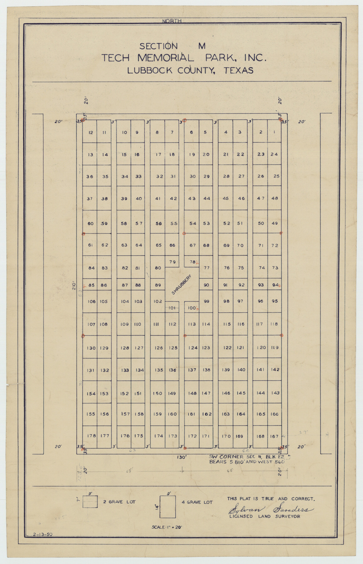
Section M, Tech Memorial Park, Inc.
-
Map/Doc
92271
-
Collection
Twichell Survey Records
-
Object Dates
2/13/1950 (Creation Date)
-
People and Organizations
Sylvan Sanders (Surveyor/Engineer)
-
Counties
Lubbock
-
Height x Width
7.6 x 11.8 inches
19.3 x 30.0 cm
Part of: Twichell Survey Records
[USGS Topo Quad map of Shafter Sheet, Presidio County]
![91754, [USGS Topo Quad map of Shafter Sheet, Presidio County], Twichell Survey Records](https://historictexasmaps.com/wmedia_w700/maps/91754-1.tif.jpg)
Print $20.00
- Digital $50.00
[USGS Topo Quad map of Shafter Sheet, Presidio County]
1895
Size 16.9 x 20.5 inches
Map/Doc 91754
Reconnaissance Map, Roby Sheet

Print $20.00
- Digital $50.00
Reconnaissance Map, Roby Sheet
1893
Size 17.0 x 20.8 inches
Map/Doc 90869
[Parts of Blocks 33, 34, 35, and 36, Township 3 North]
![91288, [Parts of Blocks 33, 34, 35, and 36, Township 3 North], Twichell Survey Records](https://historictexasmaps.com/wmedia_w700/maps/91288-1.tif.jpg)
Print $3.00
- Digital $50.00
[Parts of Blocks 33, 34, 35, and 36, Township 3 North]
Size 12.4 x 9.5 inches
Map/Doc 91288
Corrected Map of Blocks 1C, 2, 2B and 3B, G. H. & H. RR. Co. Surveys, Sherman and Hansford Counties

Print $20.00
- Digital $50.00
Corrected Map of Blocks 1C, 2, 2B and 3B, G. H. & H. RR. Co. Surveys, Sherman and Hansford Counties
1919
Size 32.0 x 34.3 inches
Map/Doc 91924
[South Part of Terrell County, West Part of Val Verde County]
![91960, [South Part of Terrell County, West Part of Val Verde County], Twichell Survey Records](https://historictexasmaps.com/wmedia_w700/maps/91960-1.tif.jpg)
Print $20.00
- Digital $50.00
[South Part of Terrell County, West Part of Val Verde County]
Size 38.6 x 18.5 inches
Map/Doc 91960
Topographic Map, Low Rent Housing Project Texas 18-1, Housing Authority of the City of Lubbock (Plan No. 2)

Print $20.00
- Digital $50.00
Topographic Map, Low Rent Housing Project Texas 18-1, Housing Authority of the City of Lubbock (Plan No. 2)
1941
Size 42.4 x 27.2 inches
Map/Doc 92757
T. C. Ivey Ranch, Block D, Yoakum Co., Texas

Print $20.00
- Digital $50.00
T. C. Ivey Ranch, Block D, Yoakum Co., Texas
Size 17.1 x 14.6 inches
Map/Doc 91976
[Surveys in Southeast part of Stephens County]
![91909, [Surveys in Southeast part of Stephens County], Twichell Survey Records](https://historictexasmaps.com/wmedia_w700/maps/91909-1.tif.jpg)
Print $2.00
- Digital $50.00
[Surveys in Southeast part of Stephens County]
Size 9.1 x 7.0 inches
Map/Doc 91909
[Blocks T2 and T3]
![90992, [Blocks T2 and T3], Twichell Survey Records](https://historictexasmaps.com/wmedia_w700/maps/90992-1.tif.jpg)
Print $20.00
- Digital $50.00
[Blocks T2 and T3]
Size 12.2 x 14.6 inches
Map/Doc 90992
Hill Ranch, Gaines County, Texas

Print $3.00
- Digital $50.00
Hill Ranch, Gaines County, Texas
1951
Size 11.5 x 14.0 inches
Map/Doc 92676
Counties of Martin, Dawson, Borden, and Howard, Texas Soash Lands, Big Springs Ranch

Print $20.00
- Digital $50.00
Counties of Martin, Dawson, Borden, and Howard, Texas Soash Lands, Big Springs Ranch
Size 35.3 x 39.0 inches
Map/Doc 91224
East Part of Blk. No. 1, H. &G. N. R. R. Co. Survey

Print $40.00
- Digital $50.00
East Part of Blk. No. 1, H. &G. N. R. R. Co. Survey
Size 22.7 x 60.6 inches
Map/Doc 89626
You may also like
Duval County Working Sketch 56

Print $20.00
- Digital $50.00
Duval County Working Sketch 56
1989
Size 26.7 x 27.2 inches
Map/Doc 68780
Current Miscellaneous File 47

Print $12.00
- Digital $50.00
Current Miscellaneous File 47
1920
Size 16.3 x 9.2 inches
Map/Doc 73992
Hopkins County Boundary File 3a

Print $4.00
- Digital $50.00
Hopkins County Boundary File 3a
Size 10.7 x 8.7 inches
Map/Doc 55082
Brown County Sketch File 10

Print $40.00
- Digital $50.00
Brown County Sketch File 10
1868
Size 17.4 x 22.3 inches
Map/Doc 11019
Navarro County Working Sketch 1b

Print $20.00
- Digital $50.00
Navarro County Working Sketch 1b
Size 32.5 x 44.6 inches
Map/Doc 71230
Pecos County Rolled Sketch 148

Print $20.00
- Digital $50.00
Pecos County Rolled Sketch 148
Size 30.3 x 42.6 inches
Map/Doc 7279
Waller County Working Sketch 3

Print $20.00
- Digital $50.00
Waller County Working Sketch 3
1959
Size 35.4 x 28.8 inches
Map/Doc 72302
Hamilton County Working Sketch 14

Print $20.00
- Digital $50.00
Hamilton County Working Sketch 14
1949
Size 30.1 x 35.4 inches
Map/Doc 63352
[Sketch showing C. W. Dakan, Wm. H. Walker and surrounding surveys]
![90880, [Sketch showing C. W. Dakan, Wm. H. Walker and surrounding surveys], Twichell Survey Records](https://historictexasmaps.com/wmedia_w700/maps/90880-1.tif.jpg)
Print $2.00
- Digital $50.00
[Sketch showing C. W. Dakan, Wm. H. Walker and surrounding surveys]
1919
Size 8.9 x 12.3 inches
Map/Doc 90880
Oldham County Sketch File 12

Print $20.00
- Digital $50.00
Oldham County Sketch File 12
Size 20.0 x 20.1 inches
Map/Doc 12113
Panola County Working Sketch 13

Print $40.00
- Digital $50.00
Panola County Working Sketch 13
1945
Map/Doc 71422
Reconnoissance of Sabine River and Valley

Print $20.00
Reconnoissance of Sabine River and Valley
1863
Size 30.2 x 42.3 inches
Map/Doc 97499