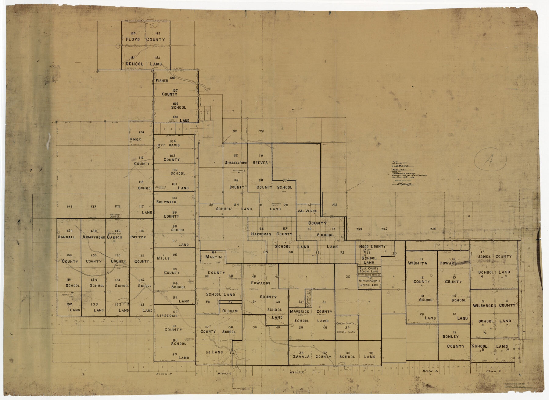
Hockley County Rolled Sketch 7
[Sketch of County School Land in Hockley County]
-
Map/Doc
9176
-
Collection
General Map Collection
-
Object Dates
3/4/1946 (File Date)
-
People and Organizations
W.J. Williams (Surveyor/Engineer)
W.D. Twichell (Surveyor/Engineer)
-
Counties
Hockley
-
Subjects
Surveying Rolled Sketch
-
Height x Width
41.4 x 56.6 inches
105.2 x 143.8 cm
-
Medium
van dyke/brownline/sepia
-
Comments
Copy of Twichell's sketch submitted to the GLO by W.J. Williams.
Part of: General Map Collection
Navigation Maps of Gulf Intracoastal Waterway, Port Arthur to Brownsville, Texas

Print $4.00
- Digital $50.00
Navigation Maps of Gulf Intracoastal Waterway, Port Arthur to Brownsville, Texas
1951
Size 16.6 x 21.2 inches
Map/Doc 65445
[Surveys in McMullen and McGloin's Colony along the San Antonio River]
![30, [Surveys in McMullen and McGloin's Colony along the San Antonio River], General Map Collection](https://historictexasmaps.com/wmedia_w700/maps/30-1.tif.jpg)
Print $20.00
- Digital $50.00
[Surveys in McMullen and McGloin's Colony along the San Antonio River]
1828
Size 19.3 x 24.5 inches
Map/Doc 30
Stonewall County Boundary File 4b

Print $18.00
- Digital $50.00
Stonewall County Boundary File 4b
Size 9.1 x 8.8 inches
Map/Doc 58993
Flight Mission No. CRE-2R, Frame 88, Jackson County

Print $20.00
- Digital $50.00
Flight Mission No. CRE-2R, Frame 88, Jackson County
1956
Size 15.9 x 15.9 inches
Map/Doc 85360
Harris County Working Sketch 99

Print $20.00
- Digital $50.00
Harris County Working Sketch 99
1979
Size 46.6 x 30.1 inches
Map/Doc 65991

Gregg County Rolled Sketch JB2

Print $20.00
- Digital $50.00
Gregg County Rolled Sketch JB2
1933
Size 42.0 x 35.1 inches
Map/Doc 8341
Jeff Davis County Sketch File 42

Print $20.00
- Digital $50.00
Jeff Davis County Sketch File 42
Size 21.8 x 27.9 inches
Map/Doc 11867
Travis County Rolled Sketch 60

Print $20.00
- Digital $50.00
Travis County Rolled Sketch 60
2014
Size 41.5 x 30.7 inches
Map/Doc 93723
Potter County Boundary File 3d

Print $12.00
- Digital $50.00
Potter County Boundary File 3d
Size 7.9 x 5.8 inches
Map/Doc 57987
Flight Mission No. DIX-8P, Frame 82, Aransas County

Print $20.00
- Digital $50.00
Flight Mission No. DIX-8P, Frame 82, Aransas County
1956
Size 18.6 x 22.4 inches
Map/Doc 83907
Grid Map Showing Texas, Louisiana, Arkansas, Mississippi and portions of New Mexico, Oklahoma and Tennessee

Print $40.00
- Digital $50.00
Grid Map Showing Texas, Louisiana, Arkansas, Mississippi and portions of New Mexico, Oklahoma and Tennessee
1940
Size 34.2 x 48.1 inches
Map/Doc 3121
You may also like
Flight Mission No. DQO-8K, Frame 133, Galveston County

Print $20.00
- Digital $50.00
Flight Mission No. DQO-8K, Frame 133, Galveston County
1952
Size 18.8 x 22.5 inches
Map/Doc 85198
Uvalde County Working Sketch 1

Print $20.00
- Digital $50.00
Uvalde County Working Sketch 1
1911
Size 27.3 x 21.0 inches
Map/Doc 72071
Flight Mission No. CUG-1P, Frame 83, Kleberg County

Print $20.00
- Digital $50.00
Flight Mission No. CUG-1P, Frame 83, Kleberg County
1956
Size 18.5 x 22.2 inches
Map/Doc 86148
Flight Mission No. BRE-2P, Frame 133, Nueces County

Print $20.00
- Digital $50.00
Flight Mission No. BRE-2P, Frame 133, Nueces County
1956
Size 18.5 x 22.5 inches
Map/Doc 86806
Zavala County Boundary File 2

Print $36.00
- Digital $50.00
Zavala County Boundary File 2
Size 9.2 x 4.3 inches
Map/Doc 60239
Jeff Davis County Sketch File 2a

Print $4.00
- Digital $50.00
Jeff Davis County Sketch File 2a
Size 8.3 x 3.3 inches
Map/Doc 27890
Val Verde County Sketch File 37

Print $24.00
- Digital $50.00
Val Verde County Sketch File 37
1938
Size 15.5 x 22.3 inches
Map/Doc 12578
Jefferson County Working Sketch 37

Print $40.00
- Digital $50.00
Jefferson County Working Sketch 37
1982
Size 49.9 x 36.6 inches
Map/Doc 66581
Briscoe County Rolled Sketch WL

Print $20.00
- Digital $50.00
Briscoe County Rolled Sketch WL
1936
Size 18.6 x 43.0 inches
Map/Doc 5335
Map of Panola County

Print $20.00
- Digital $50.00
Map of Panola County
1855
Size 20.4 x 19.1 inches
Map/Doc 3939
Harris County Working Sketch 89

Print $20.00
- Digital $50.00
Harris County Working Sketch 89
1972
Size 37.3 x 39.0 inches
Map/Doc 65981
Map of Henderson County

Print $40.00
- Digital $50.00
Map of Henderson County
1897
Size 28.9 x 58.9 inches
Map/Doc 66860