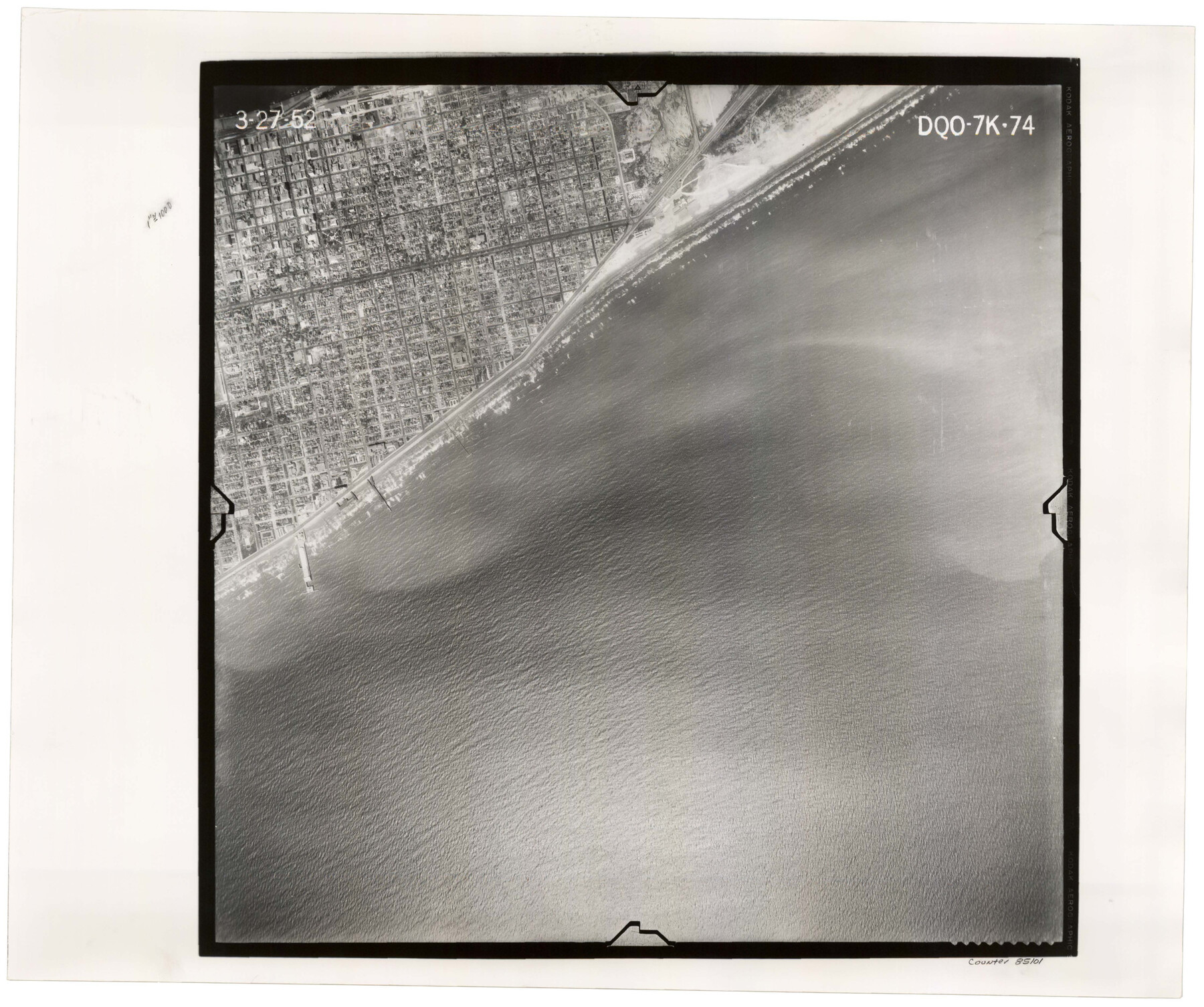
Flight Mission No. DQO-7K, Frame 74, Galveston County
DQO-7K-74
-
Map/Doc
85101
-
Collection
General Map Collection
-
Object Dates
3/27/1952 (Creation Date)
-
People and Organizations
U. S. Department of Agriculture (Publisher)
-
Counties
Galveston
-
Subjects
Aerial Photograph
-
Height x Width
18.9 x 22.5 inches
48.0 x 57.2 cm
-
Comments
Flown by Aero Exploration Company of Tulsa, Oklahoma.
Part of: General Map Collection
Parker County Sketch File 48

Print $20.00
- Digital $50.00
Parker County Sketch File 48
1858
Size 17.6 x 22.3 inches
Map/Doc 12152
San Jacinto County Sketch File 1

Print $22.00
San Jacinto County Sketch File 1
1852
Size 7.9 x 12.4 inches
Map/Doc 35694
Coast Chart No. 210 Aransas Pass and Corpus Christi Bay with the coast to latitude 27° 12' Texas

Print $20.00
- Digital $50.00
Coast Chart No. 210 Aransas Pass and Corpus Christi Bay with the coast to latitude 27° 12' Texas
1887
Size 27.5 x 18.2 inches
Map/Doc 72802
Nueces County Sketch File 19

Print $4.00
- Digital $50.00
Nueces County Sketch File 19
1875
Size 10.5 x 8.4 inches
Map/Doc 32551
Dimmit County Rolled Sketch 18

Print $20.00
- Digital $50.00
Dimmit County Rolled Sketch 18
1978
Size 20.2 x 26.0 inches
Map/Doc 5725
Nueces County Rolled Sketch 84

Print $20.00
- Digital $50.00
Nueces County Rolled Sketch 84
1982
Size 18.1 x 24.7 inches
Map/Doc 6970
Blocks No. 8, 9 & 10 Houston & Great Northern Rail Road Company Surveys in Pecos County, Texas

Print $20.00
- Digital $50.00
Blocks No. 8, 9 & 10 Houston & Great Northern Rail Road Company Surveys in Pecos County, Texas
1891
Size 24.5 x 38.7 inches
Map/Doc 3955
Sutton County Rolled Sketch 67

Print $20.00
- Digital $50.00
Sutton County Rolled Sketch 67
Size 25.4 x 37.3 inches
Map/Doc 7902
Randall County Rolled Sketch 9B

Print $20.00
- Digital $50.00
Randall County Rolled Sketch 9B
1985
Size 45.0 x 34.5 inches
Map/Doc 9810
[Maps of surveys in Reeves & Culberson Cos]
![61140, [Maps of surveys in Reeves & Culberson Cos], General Map Collection](https://historictexasmaps.com/wmedia_w700/maps/61140.tif.jpg)
Print $20.00
- Digital $50.00
[Maps of surveys in Reeves & Culberson Cos]
1937
Size 30.6 x 24.9 inches
Map/Doc 61140
Pecos County Sketch File 31 1/2a

Print $14.00
- Digital $50.00
Pecos County Sketch File 31 1/2a
1931
Size 11.2 x 8.6 inches
Map/Doc 33705
Controlled Mosaic by Jack Amman Photogrammetric Engineers, Inc - Sheet 4

Print $20.00
- Digital $50.00
Controlled Mosaic by Jack Amman Photogrammetric Engineers, Inc - Sheet 4
1954
Size 20.0 x 24.0 inches
Map/Doc 83448
You may also like
Donley County Sketch File 12

Print $2.00
- Digital $50.00
Donley County Sketch File 12
Size 12.9 x 8.2 inches
Map/Doc 21248
Map of Brazoria County

Print $20.00
- Digital $50.00
Map of Brazoria County
1883
Size 26.8 x 25.6 inches
Map/Doc 861
Angelina County Sketch File 21c

Print $4.00
- Digital $50.00
Angelina County Sketch File 21c
1889
Size 14.1 x 8.7 inches
Map/Doc 13047
Webb County Rolled Sketch 56

Print $20.00
- Digital $50.00
Webb County Rolled Sketch 56
1945
Size 22.2 x 23.7 inches
Map/Doc 8208
Smith County Working Sketch 18

Print $40.00
- Digital $50.00
Smith County Working Sketch 18
1996
Size 50.4 x 37.1 inches
Map/Doc 63903
St. Louis, Brownsville & Mexico Railway Location Map from Mile 40 to Mile 60

Print $40.00
- Digital $50.00
St. Louis, Brownsville & Mexico Railway Location Map from Mile 40 to Mile 60
1905
Size 20.3 x 136.1 inches
Map/Doc 89282
Coleman County Sketch File 24a

Print $6.00
- Digital $50.00
Coleman County Sketch File 24a
1872
Size 10.2 x 15.9 inches
Map/Doc 18708
Jefferson County Sketch File X

Print $42.00
- Digital $50.00
Jefferson County Sketch File X
Size 17.1 x 13.3 inches
Map/Doc 28087
Map of a part of Laguna Madre in Willacy & Cameron Counties showing subdivision for mineral development

Print $20.00
- Digital $50.00
Map of a part of Laguna Madre in Willacy & Cameron Counties showing subdivision for mineral development
1950
Size 46.9 x 37.0 inches
Map/Doc 3097
Winkler County Rolled Sketch 4

Print $40.00
- Digital $50.00
Winkler County Rolled Sketch 4
1927
Size 59.1 x 39.5 inches
Map/Doc 10147
Galveston County Sketch File 6

Print $4.00
- Digital $50.00
Galveston County Sketch File 6
Size 14.2 x 8.9 inches
Map/Doc 23362
Jackson County Working Sketch 5

Print $20.00
- Digital $50.00
Jackson County Working Sketch 5
1953
Size 26.2 x 26.0 inches
Map/Doc 66453