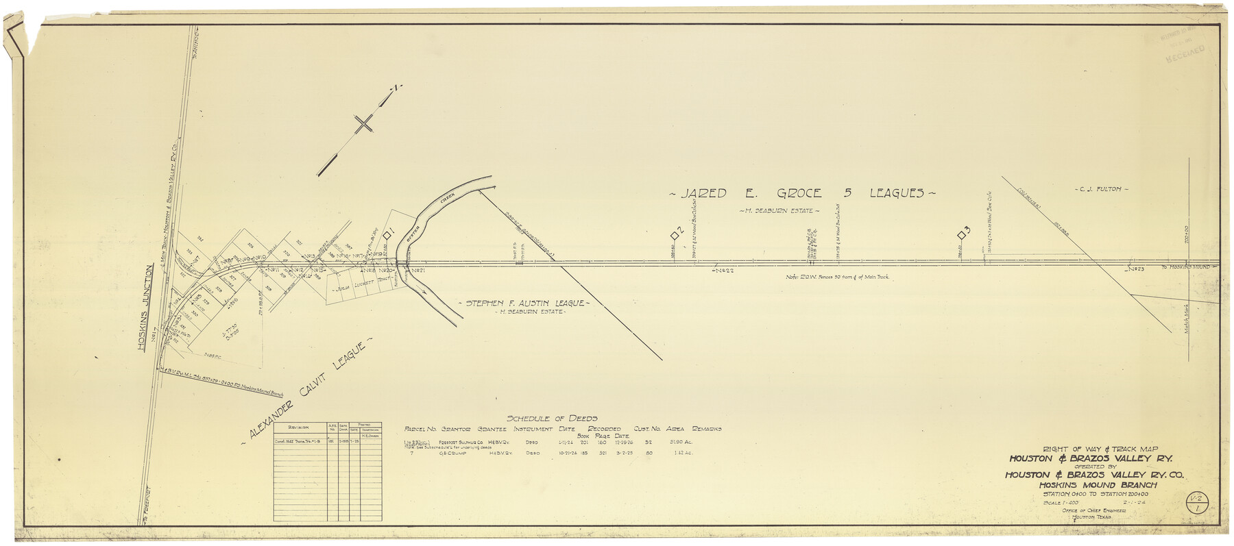
Right of Way & Track Map Houston & Brazos Valley Ry. operated by Houston & Brazos Valley Ry. Co., Hoskins Mound Branch
Station 0+00 to Station 200+00
Z-2-185
-
Map/Doc
66713
-
Collection
General Map Collection
-
Object Dates
2/12/1924 (Creation Date)
-
Counties
Brazoria
-
Subjects
Railroads
-
Height x Width
25.0 x 56.7 inches
63.5 x 144.0 cm
-
Medium
blueprint/diazo
-
Scale
1" = 400 feet
-
Comments
See counter nos. 64602 through 64611 for other sheets.
-
Features
H&BV
[Railroad line] to Hoskins Mound
Oyster Creek
[Railroad line] to Anchor
Hoskins Junction
[Railroad line] to Freeport
Part of: General Map Collection
Brazos County Working Sketch 10

Print $20.00
- Digital $50.00
Brazos County Working Sketch 10
1991
Size 15.8 x 20.7 inches
Map/Doc 67485
Orange County NRC Article 33.136 Sketch 4

Print $24.00
- Digital $50.00
Orange County NRC Article 33.136 Sketch 4
2011
Size 22.6 x 31.2 inches
Map/Doc 93271
Reagan County Working Sketch 15

Print $20.00
- Digital $50.00
Reagan County Working Sketch 15
1949
Size 27.3 x 33.0 inches
Map/Doc 71857

Roberts County Working Sketch 9

Print $20.00
- Digital $50.00
Roberts County Working Sketch 9
1964
Size 24.3 x 36.5 inches
Map/Doc 63535
Tom Green County Boundary File 87

Print $10.00
- Digital $50.00
Tom Green County Boundary File 87
Size 9.1 x 4.0 inches
Map/Doc 59393
[Sketch for Mineral Application 24072, San Jacinto River]
![65596, [Sketch for Mineral Application 24072, San Jacinto River], General Map Collection](https://historictexasmaps.com/wmedia_w700/maps/65596.tif.jpg)
Print $20.00
- Digital $50.00
[Sketch for Mineral Application 24072, San Jacinto River]
1929
Size 24.5 x 18.5 inches
Map/Doc 65596
[Sketch for Mineral Application 36425 - Jefferson County, Ley C. Moore]
![65616, [Sketch for Mineral Application 36425 - Jefferson County, Ley C. Moore], General Map Collection](https://historictexasmaps.com/wmedia_w700/maps/65616.tif.jpg)
Print $40.00
- Digital $50.00
[Sketch for Mineral Application 36425 - Jefferson County, Ley C. Moore]
1942
Size 49.2 x 35.0 inches
Map/Doc 65616
Johnson County Boundary File 51a

Print $66.00
- Digital $50.00
Johnson County Boundary File 51a
Size 12.7 x 8.2 inches
Map/Doc 55604
Coast Chart No. 210 Aransas Pass and Corpus Christi Bay with the coast to latitude 27° 12' Texas

Print $20.00
- Digital $50.00
Coast Chart No. 210 Aransas Pass and Corpus Christi Bay with the coast to latitude 27° 12' Texas
1913
Size 27.5 x 18.3 inches
Map/Doc 72799
Val Verde County Sketch File XXX4

Print $4.00
- Digital $50.00
Val Verde County Sketch File XXX4
Size 12.8 x 8.4 inches
Map/Doc 39098
[Atlas C, Table of Contents]
![78353, [Atlas C, Table of Contents], General Map Collection](https://historictexasmaps.com/wmedia_w700/maps/78353.tif.jpg)
Print $3.00
- Digital $50.00
[Atlas C, Table of Contents]
Size 14.7 x 9.6 inches
Map/Doc 78353
You may also like
Flight Mission No. CGI-3N, Frame 71, Cameron County

Print $20.00
- Digital $50.00
Flight Mission No. CGI-3N, Frame 71, Cameron County
1954
Size 18.4 x 22.3 inches
Map/Doc 84565
City of Austin, Texas - Use District Map

Print $20.00
- Digital $50.00
City of Austin, Texas - Use District Map
1943
Size 38.9 x 25.7 inches
Map/Doc 95705
Sherman County Rolled Sketch 14

Print $20.00
- Digital $50.00
Sherman County Rolled Sketch 14
1975
Size 17.4 x 17.7 inches
Map/Doc 7795
Pecos County Working Sketch 84

Print $20.00
- Digital $50.00
Pecos County Working Sketch 84
1961
Size 26.1 x 23.0 inches
Map/Doc 71556
[Sketch for Mineral Application 1112 - Colorado River, H. E. Chambers]
![65636, [Sketch for Mineral Application 1112 - Colorado River, H. E. Chambers], General Map Collection](https://historictexasmaps.com/wmedia_w700/maps/65636.tif.jpg)
Print $40.00
- Digital $50.00
[Sketch for Mineral Application 1112 - Colorado River, H. E. Chambers]
1918
Size 48.2 x 26.5 inches
Map/Doc 65636
Duval County Rolled Sketch WSR

Print $20.00
- Digital $50.00
Duval County Rolled Sketch WSR
1938
Size 39.2 x 26.8 inches
Map/Doc 5772
Harris County Working Sketch 35

Print $20.00
- Digital $50.00
Harris County Working Sketch 35
1938
Size 28.8 x 25.2 inches
Map/Doc 65927
Borden County Rolled Sketch 3

Print $20.00
- Digital $50.00
Borden County Rolled Sketch 3
1908
Size 29.0 x 33.6 inches
Map/Doc 5155
Southern Pacific R.R. and connections

Print $20.00
- Digital $50.00
Southern Pacific R.R. and connections
1883
Size 27.9 x 32.5 inches
Map/Doc 94270
Preliminary Chart No. 31 of the Sea Coast of the United States from Galveston Bay to Matagorda Bay, Texas

Print $20.00
- Digital $50.00
Preliminary Chart No. 31 of the Sea Coast of the United States from Galveston Bay to Matagorda Bay, Texas
1857
Size 23.3 x 28.1 inches
Map/Doc 69950
Hopkins County Sketch File 20

Print $4.00
- Digital $50.00
Hopkins County Sketch File 20
1871
Size 12.8 x 8.3 inches
Map/Doc 26725
Wilson County Boundary File 1

Print $58.00
- Digital $50.00
Wilson County Boundary File 1
Size 9.6 x 4.5 inches
Map/Doc 60058