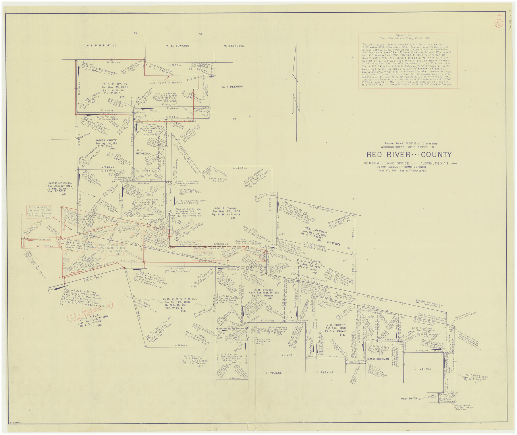
Red River County Working Sketch 35
-
Map/Doc
72018
-
Collection
General Map Collection
-
Object Dates
3/17/1964 (Creation Date)
-
People and Organizations
Roy Buckholts (Draftsman)
-
Counties
Red River
-
Subjects
Surveying Working Sketch
-
Height x Width
34.9 x 41.0 inches
88.7 x 104.1 cm
-
Scale
1" = 300 varas
Part of: General Map Collection
La Salle County Working Sketch 14

Print $20.00
- Digital $50.00
La Salle County Working Sketch 14
1941
Size 37.8 x 36.7 inches
Map/Doc 70315
Upton County Working Sketch 43

Print $40.00
- Digital $50.00
Upton County Working Sketch 43
1962
Size 56.8 x 42.7 inches
Map/Doc 69539
Crockett County Working Sketch 8

Print $20.00
- Digital $50.00
Crockett County Working Sketch 8
1903
Size 15.2 x 30.3 inches
Map/Doc 68341
Titus County Working Sketch 5

Print $20.00
- Digital $50.00
Titus County Working Sketch 5
1962
Size 38.2 x 46.8 inches
Map/Doc 69366
Galveston County NRC Article 33.136 Sketch 17

Print $22.00
- Digital $50.00
Galveston County NRC Article 33.136 Sketch 17
2002
Size 24.1 x 36.4 inches
Map/Doc 78584
San Jacinto River and Tributaries, Texas - Survey of 1939

Print $20.00
- Digital $50.00
San Jacinto River and Tributaries, Texas - Survey of 1939
1939
Size 27.8 x 40.7 inches
Map/Doc 60308
Wood County Rolled Sketch 8

Print $20.00
- Digital $50.00
Wood County Rolled Sketch 8
1965
Size 22.6 x 34.8 inches
Map/Doc 8286
Flight Mission No. DIX-3P, Frame 135, Aransas County

Print $20.00
- Digital $50.00
Flight Mission No. DIX-3P, Frame 135, Aransas County
1956
Size 17.8 x 18.5 inches
Map/Doc 83765

Midland County Rolled Sketch 4

Print $40.00
- Digital $50.00
Midland County Rolled Sketch 4
Size 43.5 x 85.6 inches
Map/Doc 10696
Palo Pinto County

Print $20.00
- Digital $50.00
Palo Pinto County
1898
Size 44.3 x 37.3 inches
Map/Doc 78400
Hill County Sketch File 24a

Print $40.00
- Digital $50.00
Hill County Sketch File 24a
Size 13.2 x 14.3 inches
Map/Doc 26518
You may also like
Reagan County Sketch File 3

Print $20.00
- Digital $50.00
Reagan County Sketch File 3
Size 18.0 x 21.9 inches
Map/Doc 12213
Nueces County Rolled Sketch 53

Print $63.00
- Digital $50.00
Nueces County Rolled Sketch 53
1978
Size 10.1 x 15.1 inches
Map/Doc 47862
Nueces County Rolled Sketch 29

Print $20.00
- Digital $50.00
Nueces County Rolled Sketch 29
1951
Size 25.0 x 22.7 inches
Map/Doc 6875
Working Sketch in Mitchell, Sterling, and Coke Co's.

Print $20.00
- Digital $50.00
Working Sketch in Mitchell, Sterling, and Coke Co's.
1925
Size 34.2 x 30.7 inches
Map/Doc 91840
Limestone County Sketch File 5

Print $44.00
- Digital $50.00
Limestone County Sketch File 5
1848
Size 9.7 x 7.6 inches
Map/Doc 30160
Frio County Working Sketch 20

Print $20.00
- Digital $50.00
Frio County Working Sketch 20
1985
Size 36.3 x 36.0 inches
Map/Doc 69294
Corpus Christi Harbor

Print $40.00
- Digital $50.00
Corpus Christi Harbor
1975
Size 37.6 x 51.5 inches
Map/Doc 73479

Burnet County Sketch File 28

Print $8.00
- Digital $50.00
Burnet County Sketch File 28
1874
Size 12.8 x 8.5 inches
Map/Doc 16740
Flight Mission No. CRC-2R, Frame 199, Chambers County

Print $20.00
- Digital $50.00
Flight Mission No. CRC-2R, Frame 199, Chambers County
1956
Size 18.6 x 22.4 inches
Map/Doc 84777

Hardin County Working Sketch 16

Print $20.00
- Digital $50.00
Hardin County Working Sketch 16
1940
Size 18.1 x 23.2 inches
Map/Doc 63414