![90202, [Blks A, B and C, and Irion, Floyd, Sutton and Lubbock County School Land Leagues], Twichell Survey Records](https://historictexasmaps.com/wmedia_w1800h1800/maps/90202-1.tif.jpg)
[Blks A, B and C, and Irion, Floyd, Sutton and Lubbock County School Land Leagues]
9-61
-
Map/Doc
90202
-
Collection
Twichell Survey Records
-
Counties
Bailey
-
Height x Width
15.6 x 19.2 inches
39.6 x 48.8 cm
Part of: Twichell Survey Records
[Blocks C41, C42, A1, and vicinity]
![92641, [Blocks C41, C42, A1, and vicinity], Twichell Survey Records](https://historictexasmaps.com/wmedia_w700/maps/92641-1.tif.jpg)
Print $20.00
- Digital $50.00
[Blocks C41, C42, A1, and vicinity]
Size 15.7 x 43.3 inches
Map/Doc 92641
[Public School Land Blocks B1 and B7]
![91974, [Public School Land Blocks B1 and B7], Twichell Survey Records](https://historictexasmaps.com/wmedia_w700/maps/91974-1.tif.jpg)
Print $20.00
- Digital $50.00
[Public School Land Blocks B1 and B7]
Size 22.9 x 14.8 inches
Map/Doc 91974
Sketch of Part of Moore County

Print $20.00
- Digital $50.00
Sketch of Part of Moore County
1912
Size 30.1 x 33.6 inches
Map/Doc 92293
Map [showing surveys 820-829] Along Red River
![89813, Map [showing surveys 820-829] Along Red River, Twichell Survey Records](https://historictexasmaps.com/wmedia_w700/maps/89813-1.tif.jpg)
Print $20.00
- Digital $50.00
Map [showing surveys 820-829] Along Red River
1920
Size 40.4 x 45.2 inches
Map/Doc 89813
[3KA and vicinity]
![90847, [3KA and vicinity], Twichell Survey Records](https://historictexasmaps.com/wmedia_w700/maps/90847-2.tif.jpg)
Print $20.00
- Digital $50.00
[3KA and vicinity]
Size 31.3 x 15.4 inches
Map/Doc 90847
Sheet 2 copied from Peck Book 6 [Strip Map showing T. & P. connecting lines]
![93172, Sheet 2 copied from Peck Book 6 [Strip Map showing T. & P. connecting lines], Twichell Survey Records](https://historictexasmaps.com/wmedia_w700/maps/93172-1.tif.jpg)
Print $40.00
- Digital $50.00
Sheet 2 copied from Peck Book 6 [Strip Map showing T. & P. connecting lines]
1909
Size 6.5 x 53.9 inches
Map/Doc 93172
Part of a map showing resurvey of Capitol Leagues by R. S. Hunnicutt & Behn Cook State Surveyors

Print $20.00
- Digital $50.00
Part of a map showing resurvey of Capitol Leagues by R. S. Hunnicutt & Behn Cook State Surveyors
Size 21.6 x 17.3 inches
Map/Doc 90277
[H. & T. C. Blocks 3 and 4; G. H. & S. A Blocks 2, 4, and 12; D. & P. Block 3]
![91027, [H. & T. C. Blocks 3 and 4; G. H. & S. A Blocks 2, 4, and 12; D. & P. Block 3], Twichell Survey Records](https://historictexasmaps.com/wmedia_w700/maps/91027-1.tif.jpg)
Print $20.00
- Digital $50.00
[H. & T. C. Blocks 3 and 4; G. H. & S. A Blocks 2, 4, and 12; D. & P. Block 3]
Size 44.6 x 36.3 inches
Map/Doc 91027
[Wm. Baker and Chas. Lydings surveys and vicinity]
![92988, [Wm. Baker and Chas. Lydings surveys and vicinity], Twichell Survey Records](https://historictexasmaps.com/wmedia_w700/maps/92988-1.tif.jpg)
Print $2.00
- Digital $50.00
[Wm. Baker and Chas. Lydings surveys and vicinity]
Size 6.6 x 7.0 inches
Map/Doc 92988
General Highway Map, Concho County, Texas

Print $20.00
- Digital $50.00
General Highway Map, Concho County, Texas
1954
Size 18.7 x 25.8 inches
Map/Doc 92551
[Block RG, Sections 1, 2, and 16, North Line of San Augustine County School Land]
![91392, [Block RG, Sections 1, 2, and 16, North Line of San Augustine County School Land], Twichell Survey Records](https://historictexasmaps.com/wmedia_w700/maps/91392-1.tif.jpg)
Print $20.00
- Digital $50.00
[Block RG, Sections 1, 2, and 16, North Line of San Augustine County School Land]
Size 25.7 x 12.4 inches
Map/Doc 91392

You may also like
Val Verde County Sketch File L

Print $26.00
- Digital $50.00
Val Verde County Sketch File L
1919
Size 12.4 x 9.1 inches
Map/Doc 39262
Atascosa County Working Sketch 26

Print $20.00
- Digital $50.00
Atascosa County Working Sketch 26
1960
Size 46.9 x 43.7 inches
Map/Doc 67222
[E. L. & R. R., Blocks 10, 9, 3, and 1]
![91346, [E. L. & R. R., Blocks 10, 9, 3, and 1], Twichell Survey Records](https://historictexasmaps.com/wmedia_w700/maps/91346-1.tif.jpg)
Print $20.00
- Digital $50.00
[E. L. & R. R., Blocks 10, 9, 3, and 1]
Size 16.0 x 23.0 inches
Map/Doc 91346
Galveston County Rolled Sketch 28

Print $347.00
- Digital $50.00
Galveston County Rolled Sketch 28
Size 22.6 x 18.1 inches
Map/Doc 6068
Duval County Rolled Sketch 41

Print $20.00
- Digital $50.00
Duval County Rolled Sketch 41
1966
Size 23.3 x 21.1 inches
Map/Doc 5758
Flight Mission No. BRA-16M, Frame 179, Jefferson County

Print $20.00
- Digital $50.00
Flight Mission No. BRA-16M, Frame 179, Jefferson County
1953
Size 18.7 x 22.2 inches
Map/Doc 85777
[R. T. Bucy's Survey 3, League 321]
![91348, [R. T. Bucy's Survey 3, League 321], Twichell Survey Records](https://historictexasmaps.com/wmedia_w700/maps/91348.tif.jpg)
Digital $50.00
[R. T. Bucy's Survey 3, League 321]
Map/Doc 91348
[Sketch of area around C. & M. RR. Co. survey 171]
![90214, [Sketch of area around C. & M. RR. Co. survey 171], Twichell Survey Records](https://historictexasmaps.com/wmedia_w700/maps/90214-1.tif.jpg)
Print $20.00
- Digital $50.00
[Sketch of area around C. & M. RR. Co. survey 171]
1924
Size 21.8 x 26.9 inches
Map/Doc 90214
Lampasas County Boundary File 8

Print $67.00
- Digital $50.00
Lampasas County Boundary File 8
Size 11.0 x 17.0 inches
Map/Doc 56158
Orange County Working Sketch 9
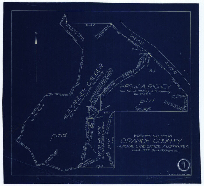
Print $3.00
- Digital $50.00
Orange County Working Sketch 9
1922
Size 10.6 x 11.6 inches
Map/Doc 71341
Pecos County Rolled Sketch 169

Print $40.00
- Digital $50.00
Pecos County Rolled Sketch 169
1927
Size 63.8 x 30.0 inches
Map/Doc 9749
Garza County Sketch File X

Print $22.00
- Digital $50.00
Garza County Sketch File X
Size 17.1 x 12.3 inches
Map/Doc 24042