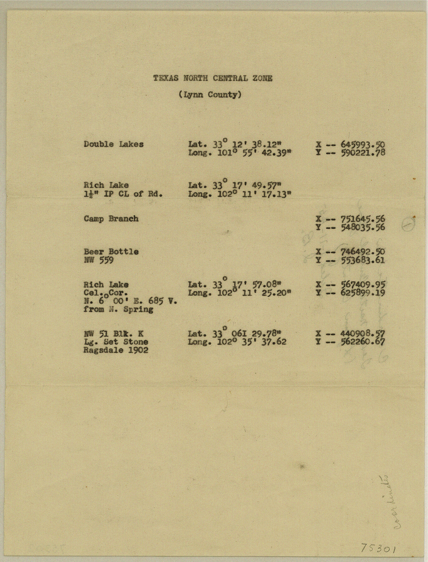
Texas Coordinate File 1
[Coordinates in Texas North Central Zone (Lynn County)]
-
Map/Doc
75301
-
Collection
General Map Collection
-
Counties
Lynn
-
Subjects
Coordinates
-
Height x Width
11.4 x 8.7 inches
29.0 x 22.1 cm
Part of: General Map Collection
Cooke County Sketch File 39

Print $20.00
- Digital $50.00
Cooke County Sketch File 39
1927
Size 10.9 x 18.2 inches
Map/Doc 11176
Potter County Boundary File 3

Print $10.00
- Digital $50.00
Potter County Boundary File 3
Size 5.8 x 8.9 inches
Map/Doc 57974
Borden County Sketch File 7

Print $8.00
- Digital $50.00
Borden County Sketch File 7
1909
Size 13.3 x 8.4 inches
Map/Doc 14723
Hansford County Working Sketch 3

Print $20.00
- Digital $50.00
Hansford County Working Sketch 3
1940
Size 20.5 x 16.5 inches
Map/Doc 63375
Schleicher County

Print $40.00
- Digital $50.00
Schleicher County
1898
Size 35.1 x 52.9 inches
Map/Doc 63026
Right of Way & Track Map, St. Louis, Brownsville & Mexico Ry. operated by St. Louis, Brownsville & Mexico Ry. Co.

Print $40.00
- Digital $50.00
Right of Way & Track Map, St. Louis, Brownsville & Mexico Ry. operated by St. Louis, Brownsville & Mexico Ry. Co.
1919
Size 25.4 x 57.1 inches
Map/Doc 64618
Hunt County Rolled Sketch 5

Print $20.00
- Digital $50.00
Hunt County Rolled Sketch 5
1956
Size 27.6 x 24.8 inches
Map/Doc 6270
Sherman County Rolled Sketch 12

Print $40.00
- Digital $50.00
Sherman County Rolled Sketch 12
1951
Size 63.9 x 11.3 inches
Map/Doc 10611
Travis County Rolled Sketch 47

Print $40.00
- Digital $50.00
Travis County Rolled Sketch 47
1923
Size 57.3 x 26.5 inches
Map/Doc 10626
Map of Fannin County

Print $20.00
- Digital $50.00
Map of Fannin County
1845
Size 34.7 x 36.5 inches
Map/Doc 16827
Stonewall County Working Sketch 10

Print $20.00
- Digital $50.00
Stonewall County Working Sketch 10
1950
Size 16.8 x 22.8 inches
Map/Doc 62317
Crockett County Working Sketch 66

Print $40.00
- Digital $50.00
Crockett County Working Sketch 66
1959
Size 62.7 x 44.0 inches
Map/Doc 68399
You may also like
Harris County Sketch File 21

Print $4.00
- Digital $50.00
Harris County Sketch File 21
1862
Size 13.1 x 8.2 inches
Map/Doc 25373
Plano del Lago de San Bernardo en el Seno Mexicano

Print $20.00
Plano del Lago de San Bernardo en el Seno Mexicano
1783
Size 17.7 x 13.8 inches
Map/Doc 93615
Deaf Smith County Rolled Sketch 4

Print $20.00
- Digital $50.00
Deaf Smith County Rolled Sketch 4
Size 23.9 x 18.0 inches
Map/Doc 96789
Kleberg County Rolled Sketch 5A

Print $20.00
- Digital $50.00
Kleberg County Rolled Sketch 5A
Size 31.0 x 25.1 inches
Map/Doc 6549
Ellis County Sketch File 10

Print $40.00
- Digital $50.00
Ellis County Sketch File 10
1860
Size 12.7 x 16.1 inches
Map/Doc 21845
Chambers County Sketch File A

Print $20.00
- Digital $50.00
Chambers County Sketch File A
1900
Size 21.3 x 21.5 inches
Map/Doc 11071
T. C. Ivey Ranch Block D

Print $20.00
- Digital $50.00
T. C. Ivey Ranch Block D
Size 17.5 x 14.8 inches
Map/Doc 92846
Map of the County of Nueces

Print $20.00
- Digital $50.00
Map of the County of Nueces
1859
Size 39.3 x 39.6 inches
Map/Doc 78391
Tyler County Rolled Sketch 3

Print $20.00
- Digital $50.00
Tyler County Rolled Sketch 3
1946
Size 45.5 x 35.6 inches
Map/Doc 10027
El Paso County Sketch File 33

Print $2.00
- Digital $50.00
El Paso County Sketch File 33
1983
Size 9.0 x 14.5 inches
Map/Doc 22128
Mitchell County Working Sketch 7

Print $20.00
- Digital $50.00
Mitchell County Working Sketch 7
1963
Size 38.6 x 22.6 inches
Map/Doc 71064
Grayson County Rolled Sketch 2

Print $20.00
- Digital $50.00
Grayson County Rolled Sketch 2
1951
Size 25.5 x 42.5 inches
Map/Doc 6030