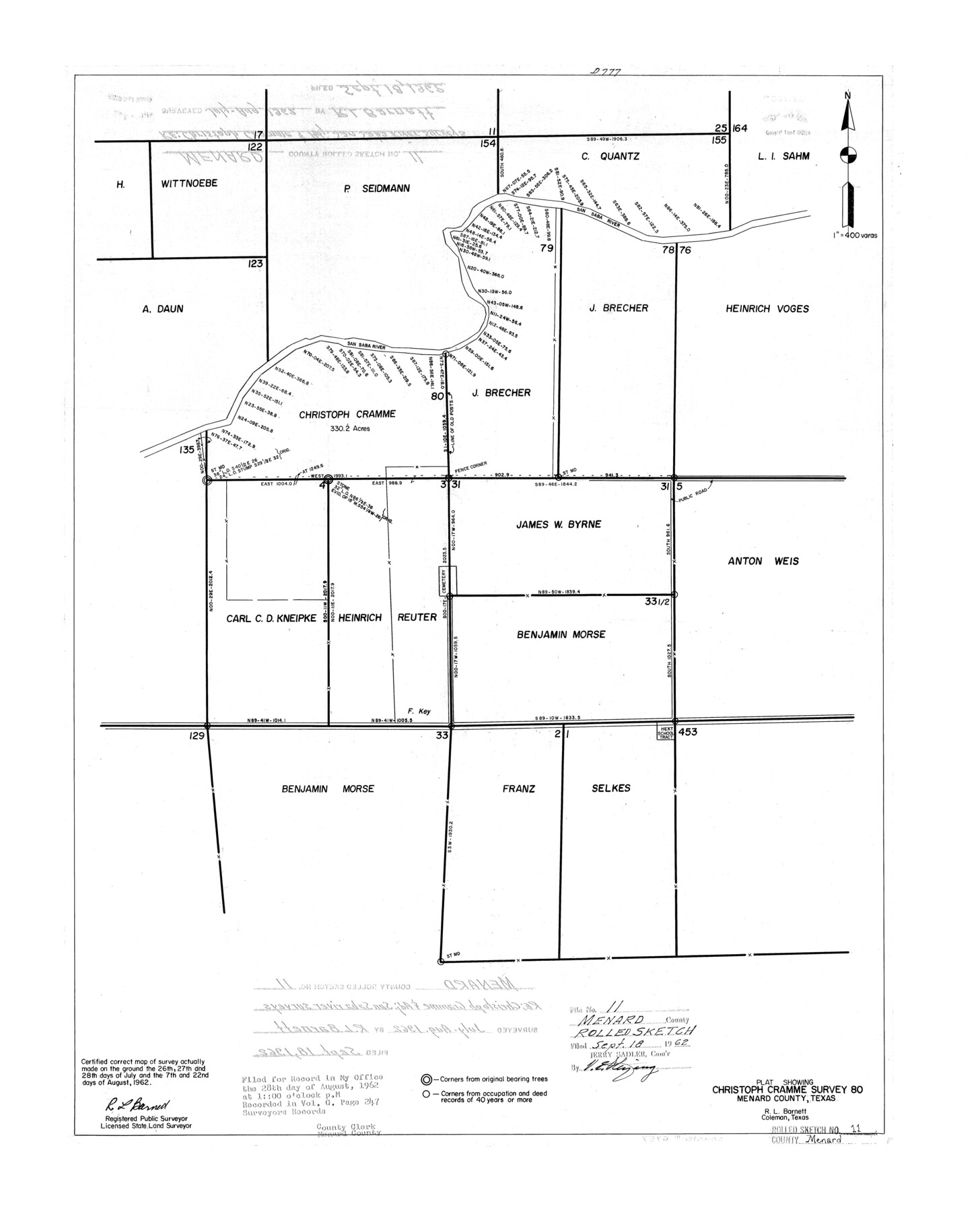
Menard County Rolled Sketch 11
Plat showing Christoph Cramme survey 80, Menard County, Texas
-
Map/Doc
6757
-
Collection
General Map Collection
-
Object Dates
1962/8/22 (Creation Date)
1962/9/18 (File Date)
-
People and Organizations
R.L. Barnett (Surveyor/Engineer)
-
Counties
Menard
-
Subjects
Surveying Rolled Sketch
-
Height x Width
24.8 x 20.1 inches
63.0 x 51.1 cm
-
Scale
1" = 400 varas
Part of: General Map Collection
Pecos County Sketch [University Blocks 19 and 20]
![2439, Pecos County Sketch [University Blocks 19 and 20], General Map Collection](https://historictexasmaps.com/wmedia_w700/maps/2439-1.tif.jpg)
Print $20.00
- Digital $50.00
Pecos County Sketch [University Blocks 19 and 20]
1951
Size 31.3 x 15.8 inches
Map/Doc 2439
Terrell County Working Sketch 74

Print $20.00
- Digital $50.00
Terrell County Working Sketch 74
1981
Size 37.5 x 24.6 inches
Map/Doc 69595
Hudspeth County Rolled Sketch 69

Print $20.00
- Digital $50.00
Hudspeth County Rolled Sketch 69
1973
Size 12.3 x 19.2 inches
Map/Doc 7718
Pecos County Working Sketch 95

Print $20.00
- Digital $50.00
Pecos County Working Sketch 95
1970
Size 42.6 x 40.6 inches
Map/Doc 71568

Rusk County Working Sketch 9

Print $20.00
- Digital $50.00
Rusk County Working Sketch 9
1981
Size 28.3 x 32.3 inches
Map/Doc 63644
Maps of Gulf Intracoastal Waterway, Texas - Sabine River to the Rio Grande and connecting waterways including ship channels

Print $20.00
- Digital $50.00
Maps of Gulf Intracoastal Waterway, Texas - Sabine River to the Rio Grande and connecting waterways including ship channels
1966
Size 14.5 x 22.2 inches
Map/Doc 61915
Hutchinson County Working Sketch 19

Print $20.00
- Digital $50.00
Hutchinson County Working Sketch 19
1960
Size 18.8 x 18.3 inches
Map/Doc 66379
La Salle County Working Sketch 34

Print $20.00
- Digital $50.00
La Salle County Working Sketch 34
1956
Size 18.8 x 26.2 inches
Map/Doc 70335
Flight Mission No. DQN-2K, Frame 164, Calhoun County

Print $20.00
- Digital $50.00
Flight Mission No. DQN-2K, Frame 164, Calhoun County
1953
Size 18.7 x 22.5 inches
Map/Doc 84326
Taylor County Sketch File 21

Print $10.00
- Digital $50.00
Taylor County Sketch File 21
1962
Size 11.3 x 8.8 inches
Map/Doc 37821
Flight Mission No. DQN-7K, Frame 89, Calhoun County

Print $20.00
- Digital $50.00
Flight Mission No. DQN-7K, Frame 89, Calhoun County
1953
Size 18.4 x 22.2 inches
Map/Doc 84480
You may also like
Uvalde County Working Sketch 44

Print $20.00
- Digital $50.00
Uvalde County Working Sketch 44
1978
Size 27.6 x 32.7 inches
Map/Doc 72114
Matagorda County Sketch File 38

Print $20.00
- Digital $50.00
Matagorda County Sketch File 38
1904
Size 24.4 x 33.0 inches
Map/Doc 12046
Sterling County Rolled Sketch 38

Print $20.00
- Digital $50.00
Sterling County Rolled Sketch 38
1988
Size 25.0 x 31.7 inches
Map/Doc 7863
Borden County Sketch File 4

Print $24.00
- Digital $50.00
Borden County Sketch File 4
1903
Size 8.8 x 7.8 inches
Map/Doc 14707
Liberty County Working Sketch 32

Print $20.00
- Digital $50.00
Liberty County Working Sketch 32
1945
Size 29.1 x 46.3 inches
Map/Doc 70491
Gregg County Rolled Sketch 7

Print $20.00
- Digital $50.00
Gregg County Rolled Sketch 7
1933
Size 24.6 x 42.0 inches
Map/Doc 6032
[Blocks C31, C32, C36-C38 and C41-C42]
![91935, [Blocks C31, C32, C36-C38 and C41-C42], Twichell Survey Records](https://historictexasmaps.com/wmedia_w700/maps/91935-1.tif.jpg)
Print $20.00
- Digital $50.00
[Blocks C31, C32, C36-C38 and C41-C42]
Size 27.9 x 23.1 inches
Map/Doc 91935
Real County Rolled Sketch 7

Print $20.00
- Digital $50.00
Real County Rolled Sketch 7
Size 24.5 x 29.9 inches
Map/Doc 7457
Map showing lands of D. Sullivan known as Santa Rosa Ranch, situated in Cameron and Hidalgo Counties, Texas

Print $20.00
- Digital $50.00
Map showing lands of D. Sullivan known as Santa Rosa Ranch, situated in Cameron and Hidalgo Counties, Texas
1905
Size 26.8 x 27.3 inches
Map/Doc 4451
Grayson County Fannin District

Print $20.00
- Digital $50.00
Grayson County Fannin District
1885
Size 40.1 x 37.7 inches
Map/Doc 4961
Kerr County Rolled Sketch 25

Print $20.00
- Digital $50.00
Kerr County Rolled Sketch 25
Size 24.7 x 31.0 inches
Map/Doc 6505
Idalou Lubbock County Texas Located on North 1/2 Sections 2 & 41 Block D7

Print $20.00
- Digital $50.00
Idalou Lubbock County Texas Located on North 1/2 Sections 2 & 41 Block D7
Size 30.0 x 16.4 inches
Map/Doc 92872