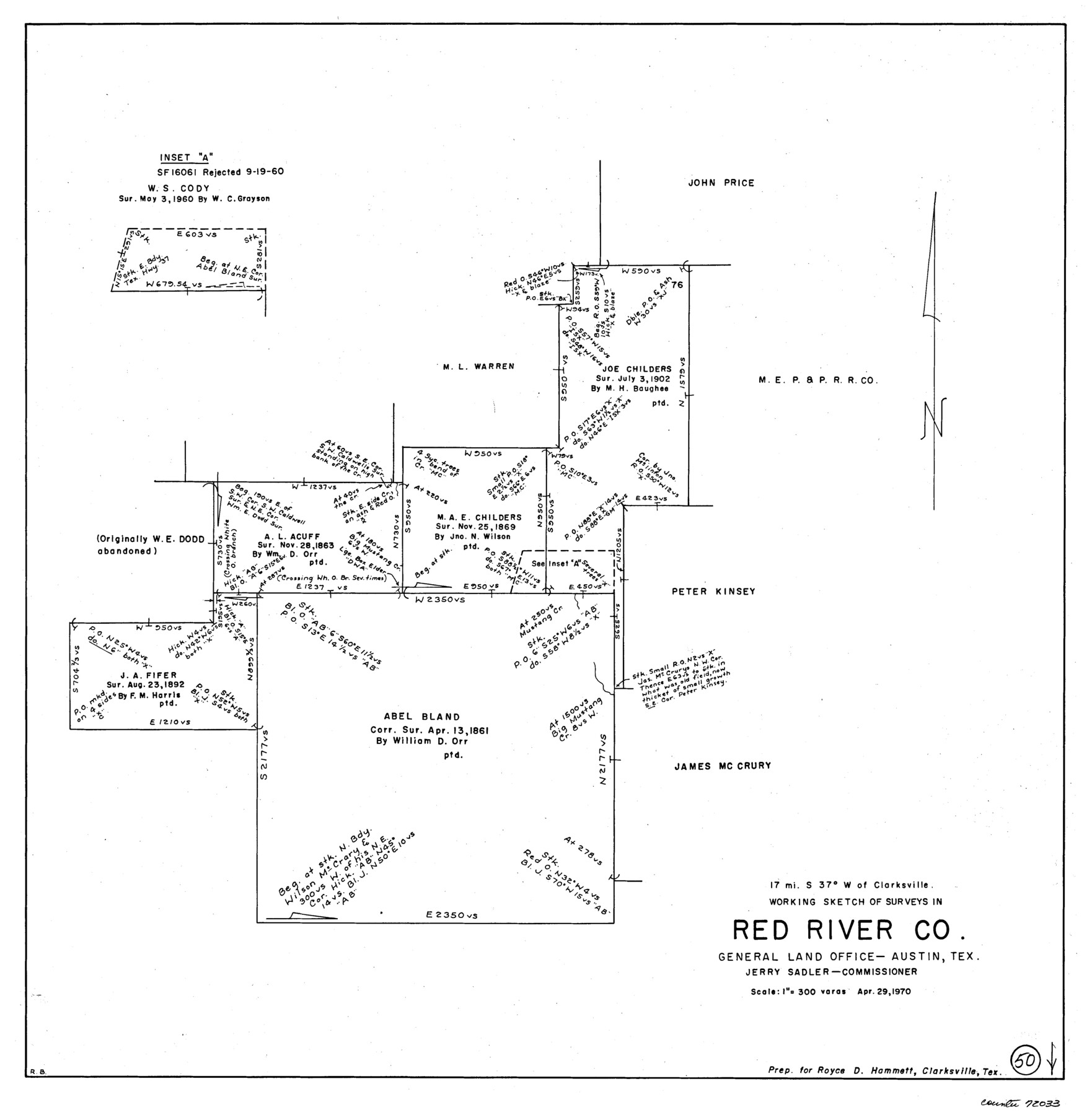
Red River County Working Sketch 50
-
Map/Doc
72033
-
Collection
General Map Collection
-
Object Dates
4/29/1970 (Creation Date)
-
People and Organizations
Roy Buckholts (Draftsman)
-
Counties
Red River
-
Subjects
Surveying Working Sketch
-
Height x Width
24.6 x 24.1 inches
62.5 x 61.2 cm
-
Scale
1" = 300 varas
Part of: General Map Collection
Dawson County

Print $20.00
- Digital $50.00
Dawson County
1892
Size 27.1 x 23.3 inches
Map/Doc 66797
Hardeman County Working Sketch 15

Print $40.00
- Digital $50.00
Hardeman County Working Sketch 15
1981
Size 42.9 x 49.1 inches
Map/Doc 63396
Pecos County Sketch File 55

Print $20.00
- Digital $50.00
Pecos County Sketch File 55
Size 43.1 x 20.4 inches
Map/Doc 10570
Hydograhic Survey H-994, Corpus Christi Pass

Print $40.00
- Digital $50.00
Hydograhic Survey H-994, Corpus Christi Pass
1869
Size 31.8 x 53.7 inches
Map/Doc 2701
Pecos County Working Sketch 77

Print $20.00
- Digital $50.00
Pecos County Working Sketch 77
1959
Size 32.0 x 36.4 inches
Map/Doc 71549
Mills County Rolled Sketch 6

Print $20.00
- Digital $50.00
Mills County Rolled Sketch 6
2007
Size 24.4 x 36.6 inches
Map/Doc 88738
Map of the Surveyed Part of Young District

Print $40.00
- Digital $50.00
Map of the Surveyed Part of Young District
1860
Size 56.3 x 27.3 inches
Map/Doc 87374
Tom Green County Sketch File 55 1/2

Print $20.00
- Digital $50.00
Tom Green County Sketch File 55 1/2
1886
Size 26.4 x 13.6 inches
Map/Doc 12443
Survey of The Rio Grande Roma to the Gulf of Mexico

Survey of The Rio Grande Roma to the Gulf of Mexico
Map/Doc 81739
Tom Green County Sketch File 1

Print $4.00
- Digital $50.00
Tom Green County Sketch File 1
Size 8.1 x 12.7 inches
Map/Doc 38159
Haskell County Working Sketch 3

Print $20.00
- Digital $50.00
Haskell County Working Sketch 3
1920
Size 41.4 x 21.9 inches
Map/Doc 66061
Map of the Western Part of Bexar District

Print $40.00
- Digital $50.00
Map of the Western Part of Bexar District
1849
Size 63.7 x 36.2 inches
Map/Doc 87376
You may also like
Reagan County Rolled Sketch 5

Print $20.00
- Digital $50.00
Reagan County Rolled Sketch 5
1928
Size 26.8 x 22.1 inches
Map/Doc 7434
Wichita County Sketch File A

Print $4.00
- Digital $50.00
Wichita County Sketch File A
1861
Size 7.8 x 10.3 inches
Map/Doc 40036

Duval County Sketch File 55

Print $20.00
- Digital $50.00
Duval County Sketch File 55
1937
Size 22.3 x 17.1 inches
Map/Doc 11404
[Surveying Sketch of Jesse McGee in Sabine and Newton Counties]
![78480, [Surveying Sketch of Jesse McGee in Sabine and Newton Counties], Maddox Collection](https://historictexasmaps.com/wmedia_w700/maps/78480.tif.jpg)
Print $20.00
- Digital $50.00
[Surveying Sketch of Jesse McGee in Sabine and Newton Counties]
Size 17.1 x 19.7 inches
Map/Doc 78480
Kendall County Sketch File 28

Print $12.00
- Digital $50.00
Kendall County Sketch File 28
1953
Size 14.3 x 8.9 inches
Map/Doc 28733
Tyler County Working Sketch 10

Print $20.00
- Digital $50.00
Tyler County Working Sketch 10
1937
Size 24.0 x 24.1 inches
Map/Doc 69480
Brewster County Rolled Sketch 22D

Print $20.00
- Digital $50.00
Brewster County Rolled Sketch 22D
1910
Size 32.3 x 24.9 inches
Map/Doc 5205
Lampasas County Rolled Sketch 2

Print $20.00
- Digital $50.00
Lampasas County Rolled Sketch 2
Size 21.0 x 39.2 inches
Map/Doc 6565
Texas 1971 Official State Highway Map

Digital $50.00
Texas 1971 Official State Highway Map
Size 27.9 x 36.3 inches
Map/Doc 94315
Subdivision Map of Fisher County School Land situated in Bailey and Cochran Counties, Texas

Print $20.00
- Digital $50.00
Subdivision Map of Fisher County School Land situated in Bailey and Cochran Counties, Texas
1924
Size 20.0 x 29.6 inches
Map/Doc 90243
[Kent County Block 4, Sections 33 and 46, Block 97, Sections 771 and 772]
![92192, [Kent County Block 4, Sections 33 and 46, Block 97, Sections 771 and 772], Twichell Survey Records](https://historictexasmaps.com/wmedia_w700/maps/92192-1.tif.jpg)
Print $2.00
- Digital $50.00
[Kent County Block 4, Sections 33 and 46, Block 97, Sections 771 and 772]
1951
Size 8.7 x 15.6 inches
Map/Doc 92192