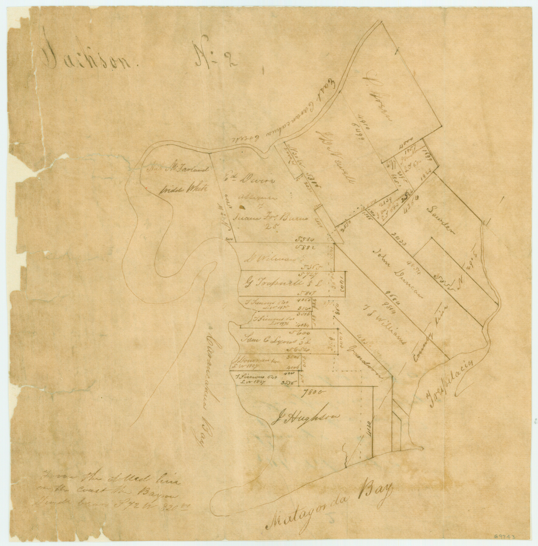
Sketch of Surveys on Caranchua and Tres Palacious Bayous, Jackson Co.
Atlas G, Page 7, Sketch 2 (G-7-2)
G-7-2
-
Map/Doc
69743
-
Collection
General Map Collection
-
People and Organizations
[Simons] (Surveyor/Engineer)
-
Counties
Matagorda Jackson Calhoun
-
Subjects
Atlas
-
Height x Width
7.9 x 7.8 inches
20.1 x 19.8 cm
-
Medium
paper, manuscript
-
Comments
Conserved in 2004.
-
Features
East Caramcahua Creek
Trespalacios [Bayou]
Carancahua Bay
Matagorda Bay
Part of: General Map Collection
San Augustine County Sketch File 16

Print $8.00
San Augustine County Sketch File 16
1946
Size 11.3 x 8.6 inches
Map/Doc 35664
Maps & Lists Showing Prison Lands (Oil & Gas) Leased as of June 1955

Print $2.00
- Digital $50.00
Maps & Lists Showing Prison Lands (Oil & Gas) Leased as of June 1955
1955
Size 11.2 x 8.8 inches
Map/Doc 62863
Fannin County Rolled Sketch 18G

Print $20.00
- Digital $50.00
Fannin County Rolled Sketch 18G
Size 27.9 x 36.0 inches
Map/Doc 5874
Lubbock County Sketch File 3

Print $4.00
- Digital $50.00
Lubbock County Sketch File 3
1901
Size 13.0 x 8.2 inches
Map/Doc 30420
Presidio County Working Sketch 79

Print $40.00
- Digital $50.00
Presidio County Working Sketch 79
1966
Size 42.4 x 50.5 inches
Map/Doc 71756
Orange County Working Sketch 2

Print $20.00
- Digital $50.00
Orange County Working Sketch 2
1917
Size 12.8 x 13.1 inches
Map/Doc 71334
Culberson County Working Sketch 74

Print $40.00
- Digital $50.00
Culberson County Working Sketch 74
1975
Size 51.4 x 35.5 inches
Map/Doc 68528
Sherman County Rolled Sketch 2

Print $40.00
- Digital $50.00
Sherman County Rolled Sketch 2
1888
Size 43.9 x 67.9 inches
Map/Doc 9927
Kimble County Working Sketch 11

Print $20.00
- Digital $50.00
Kimble County Working Sketch 11
1921
Size 19.0 x 25.1 inches
Map/Doc 70079
Aransas County NRC Article 33.136 Sketch 12

Print $44.00
- Digital $50.00
Aransas County NRC Article 33.136 Sketch 12
2012
Size 36.0 x 48.0 inches
Map/Doc 94510
Central & Montgomery

Print $40.00
- Digital $50.00
Central & Montgomery
1941
Size 25.6 x 122.2 inches
Map/Doc 64522
Jim Wells County Working Sketch 4

Print $20.00
- Digital $50.00
Jim Wells County Working Sketch 4
1938
Size 44.1 x 32.8 inches
Map/Doc 66602
You may also like
Winkler County Sketch File 4

Print $8.00
- Digital $50.00
Winkler County Sketch File 4
Size 14.3 x 8.8 inches
Map/Doc 40463
History of Texas from its First Settlement in 1685 to its Annexation to the United States in 1846 (Vol. 1)

History of Texas from its First Settlement in 1685 to its Annexation to the United States in 1846 (Vol. 1)
1856
Map/Doc 97390
Controlled Mosaic by Jack Amman Photogrammetric Engineers, Inc - Sheet 19

Print $20.00
- Digital $50.00
Controlled Mosaic by Jack Amman Photogrammetric Engineers, Inc - Sheet 19
1954
Size 19.3 x 24.0 inches
Map/Doc 83465
Flight Mission No. DCL-6C, Frame 70, Kenedy County

Print $20.00
- Digital $50.00
Flight Mission No. DCL-6C, Frame 70, Kenedy County
1943
Size 18.6 x 22.3 inches
Map/Doc 85912
Culberson County Working Sketch 89

Print $20.00
- Digital $50.00
Culberson County Working Sketch 89
1984
Size 34.6 x 30.0 inches
Map/Doc 68543
Ector County Working Sketch 16

Print $40.00
- Digital $50.00
Ector County Working Sketch 16
1956
Size 31.6 x 73.6 inches
Map/Doc 68859
Sabine and Neches Rivers

Print $20.00
- Digital $50.00
Sabine and Neches Rivers
1971
Size 19.7 x 44.4 inches
Map/Doc 69817
Eastland County Sketch File 19

Print $2.00
- Digital $50.00
Eastland County Sketch File 19
1983
Size 14.3 x 9.0 inches
Map/Doc 21608
Hutchinson County Sketch File 27

Print $20.00
- Digital $50.00
Hutchinson County Sketch File 27
Size 21.0 x 24.9 inches
Map/Doc 11817
Dietzgen Globe Wooden 42" T Square

Dietzgen Globe Wooden 42" T Square
Size 44.5 x 13.8 inches
Map/Doc 97329
Irion County Sketch File 12

Print $40.00
- Digital $50.00
Irion County Sketch File 12
1939
Size 15.3 x 12.4 inches
Map/Doc 27482
San Augustine County Working Sketch 25

Print $20.00
- Digital $50.00
San Augustine County Working Sketch 25
1976
Size 28.0 x 36.6 inches
Map/Doc 63713