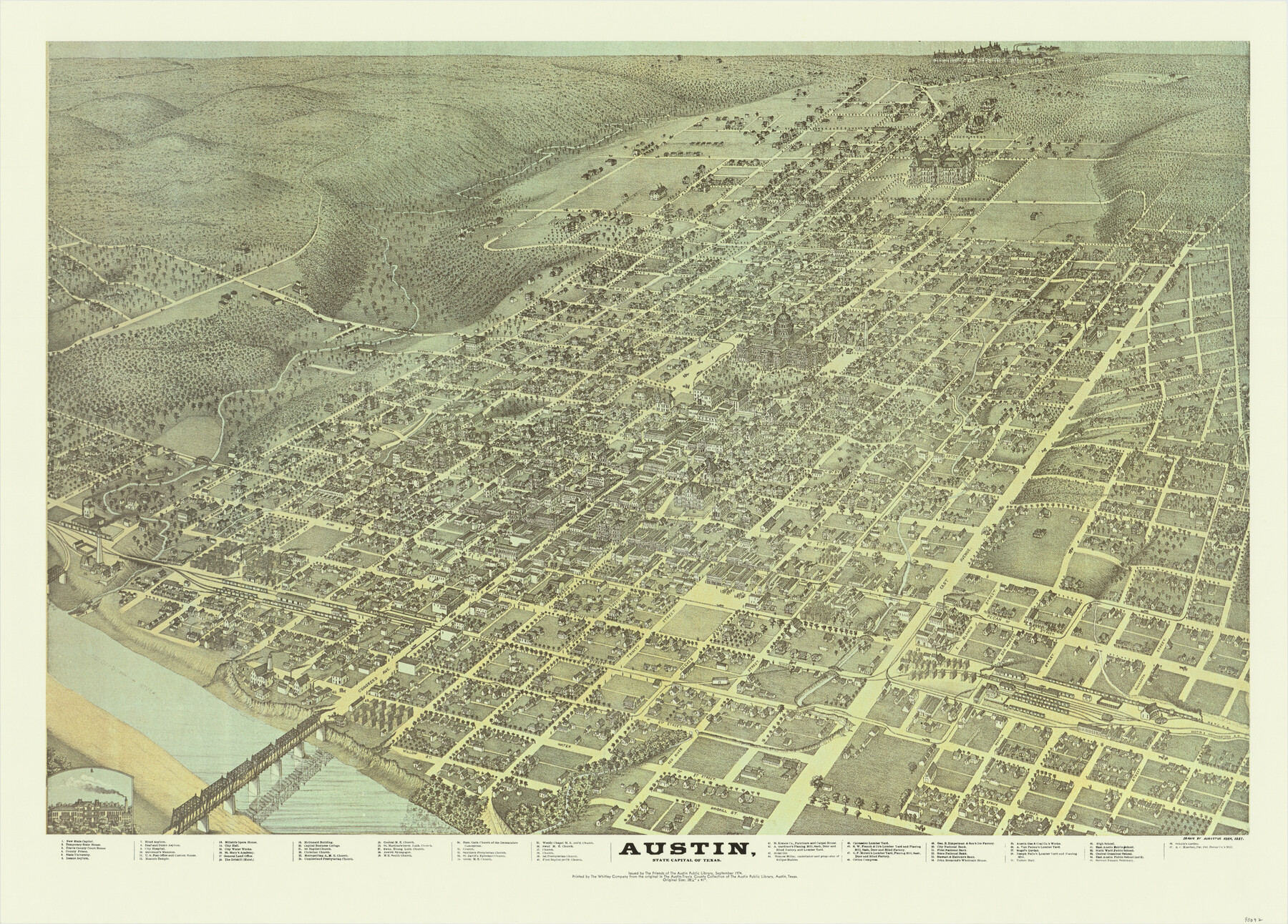
Austin, State Capital of Texas
[Bird's Eye View Map of Austin]
-
Map/Doc
90092
-
Collection
General Map Collection
-
Object Dates
1974 (Revision Date)
1887 (Creation Date)
-
People and Organizations
The Friends of the Austin Public Library (Publisher)
The Whitley Company (Printer)
Augustus Koch (Draftsman)
-
Counties
Travis
-
Subjects
Bird's Eye View City Pictorial
-
Height x Width
23.0 x 32.1 inches
58.4 x 81.5 cm
-
Medium
paper, print
-
Comments
For reference only. Copies should be obtained from the Austin History Center. Map is based on Augustus Koch's 1887 original bird's eye view map. See 89218 for a digital copy of the original map from which this was made.
-
Features
Cumberland Presbyterian Church
Central M[ethodist] E[piscopal] Church
St. Martine's Germ[an] Luth[eran] Church
Swed[ish] Evang[elical] Luth[eran] Church
Jewish Synagogue
M[ethodist] E[piscopal] South Church
First Baptist Church
Christian Church
Metropolitan A[frican] M[ethodist] E[piscopal] Church
Germ[an] M[ethodist] E[piscopal] Church
State University
St. Mary's Academy
City Hospital
Blind Asylum
Deaf and Dumb Asylum
A.C. Koerber, Pat. Pol. Pecan Co.'s Mill
Insane Asylum
Capital Business College
East Austin Public School (col'd.)
[Shoal Creek]
[Waller Creek]
Colorado River
H&TC
A&NW
East Austin Public School
Sixth Ward Public School
Central Grammar School
Austin
Steward Female Seminary
Wesley Chapel M[ethodist] E[piscopal] (col'd.) Church
Swed[ish] M[ethodist] E[piscopal] Church
First Presbyterian Church
First Baptist (col'd.) Church
Rom[an] Cath[olic] Church of the Immaculate Conception
Southern Presbyterian Church
St. David's Episcopal Church
Related maps
Austin, State Capital of Texas

Print $20.00
Austin, State Capital of Texas
1887
Size 27.5 x 40.0 inches
Map/Doc 89218
Part of: General Map Collection
Reeves County Working Sketch 46

Print $40.00
- Digital $50.00
Reeves County Working Sketch 46
1974
Size 52.4 x 37.2 inches
Map/Doc 63489
[Surveys in Burleson County]
![78355, [Surveys in Burleson County], General Map Collection](https://historictexasmaps.com/wmedia_w700/maps/78355.tif.jpg)
Print $20.00
- Digital $50.00
[Surveys in Burleson County]
Size 19.6 x 28.3 inches
Map/Doc 78355
Moore County Working Sketch 16

Print $20.00
- Digital $50.00
Moore County Working Sketch 16
1981
Size 26.3 x 23.2 inches
Map/Doc 71198
King County Sketch File 12

Print $10.00
- Digital $50.00
King County Sketch File 12
1903
Size 11.3 x 8.6 inches
Map/Doc 29105
San Jacinto County Sketch File 13

Print $4.00
San Jacinto County Sketch File 13
Size 5.3 x 8.1 inches
Map/Doc 35723
Corpus Christi Bay

Print $20.00
- Digital $50.00
Corpus Christi Bay
1976
Size 36.2 x 47.8 inches
Map/Doc 73476
Bee County Sketch File 10

Print $4.00
- Digital $50.00
Bee County Sketch File 10
Size 12.8 x 7.9 inches
Map/Doc 14291
Edwards County Boundary File 27

Print $8.00
- Digital $50.00
Edwards County Boundary File 27
Size 8.8 x 3.9 inches
Map/Doc 52876
Wood County Working Sketch 5

Print $20.00
- Digital $50.00
Wood County Working Sketch 5
1941
Size 27.8 x 38.7 inches
Map/Doc 62005
Brazos County Working Sketch 2

Print $20.00
- Digital $50.00
Brazos County Working Sketch 2
1950
Size 31.9 x 36.0 inches
Map/Doc 67477
Flight Mission No. CGI-1N, Frame 166, Cameron County

Print $20.00
- Digital $50.00
Flight Mission No. CGI-1N, Frame 166, Cameron County
1955
Size 18.5 x 22.2 inches
Map/Doc 84501
Karnes County Sketch File 13

Print $8.00
- Digital $50.00
Karnes County Sketch File 13
1897
Size 9.7 x 6.3 inches
Map/Doc 28611
You may also like
Map of Bandera County

Print $40.00
- Digital $50.00
Map of Bandera County
1885
Size 31.6 x 63.9 inches
Map/Doc 4772
Sketch of surveys in Dimmit, Maverick and Webb Cos.

Print $20.00
- Digital $50.00
Sketch of surveys in Dimmit, Maverick and Webb Cos.
1876
Size 17.9 x 14.7 inches
Map/Doc 5050
Subdivision of Sutton County School League 175, Bailey County, Texas

Print $2.00
- Digital $50.00
Subdivision of Sutton County School League 175, Bailey County, Texas
1929
Size 8.9 x 11.5 inches
Map/Doc 90201
Galveston County Rolled Sketch JK

Print $40.00
- Digital $50.00
Galveston County Rolled Sketch JK
1913
Size 25.4 x 56.5 inches
Map/Doc 9092
Karnes County Working Sketch 10

Print $20.00
- Digital $50.00
Karnes County Working Sketch 10
1970
Size 35.5 x 26.3 inches
Map/Doc 66658
Zapata County Sketch File 2

Print $20.00
- Digital $50.00
Zapata County Sketch File 2
1875
Size 24.3 x 32.8 inches
Map/Doc 12718
Comanche County Sketch File 19 1/2

Print $6.00
- Digital $50.00
Comanche County Sketch File 19 1/2
1872
Size 8.1 x 7.9 inches
Map/Doc 19098
Brooks County Sketch File 9

Print $2.00
- Digital $50.00
Brooks County Sketch File 9
1988
Size 14.4 x 8.8 inches
Map/Doc 16571
General Highway Map, Wilson County, Texas

Print $20.00
General Highway Map, Wilson County, Texas
1940
Size 18.2 x 24.8 inches
Map/Doc 79282
Palo Pinto County Working Sketch 17

Print $40.00
- Digital $50.00
Palo Pinto County Working Sketch 17
1974
Size 30.0 x 53.8 inches
Map/Doc 71400
[Part of Map Showing Terry & Lynn County Line Highlighting Parts of Blocks D8, E, 9]
![92264, [Part of Map Showing Terry & Lynn County Line Highlighting Parts of Blocks D8, E, 9], Twichell Survey Records](https://historictexasmaps.com/wmedia_w700/maps/92264-1.tif.jpg)
Print $20.00
- Digital $50.00
[Part of Map Showing Terry & Lynn County Line Highlighting Parts of Blocks D8, E, 9]
Size 18.2 x 10.9 inches
Map/Doc 92264
Kerr County Boundary File 1

Print $4.00
- Digital $50.00
Kerr County Boundary File 1
Size 12.7 x 8.1 inches
Map/Doc 55982