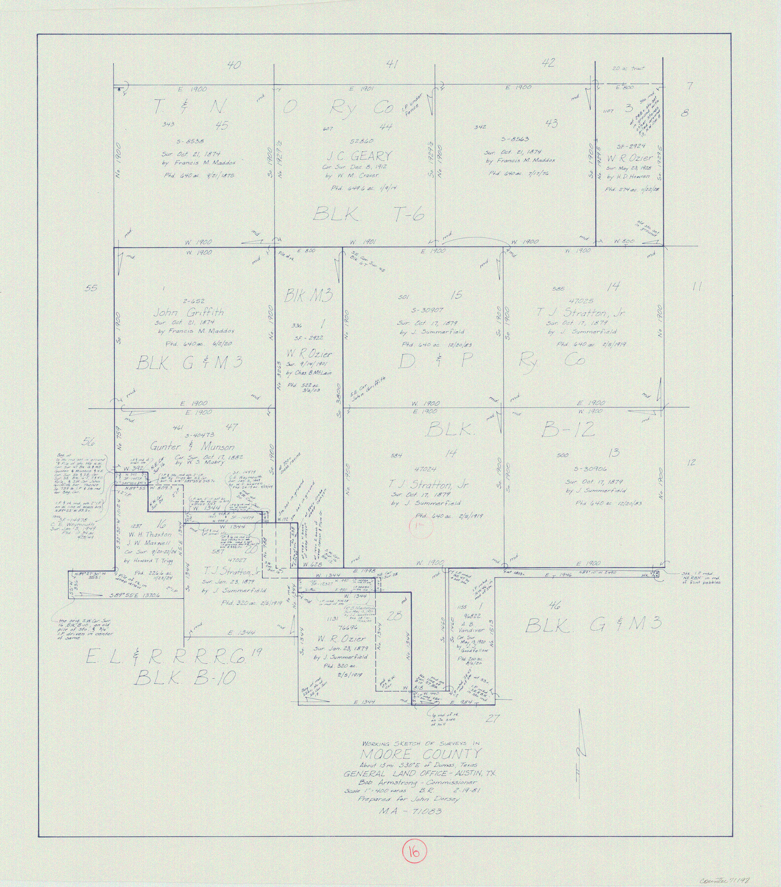
Moore County Working Sketch 16
-
Map/Doc
71198
-
Collection
General Map Collection
-
Object Dates
2/19/1981 (Creation Date)
-
People and Organizations
Beverly Robison (Draftsman)
-
Counties
Moore
-
Subjects
Surveying Working Sketch
-
Height x Width
26.3 x 23.2 inches
66.8 x 58.9 cm
-
Scale
1" = 400 varas
Part of: General Map Collection
Flight Mission No. DIX-3P, Frame 138, Aransas County

Print $20.00
- Digital $50.00
Flight Mission No. DIX-3P, Frame 138, Aransas County
1956
Size 17.7 x 18.6 inches
Map/Doc 83768
Menard County Working Sketch Graphic Index

Print $20.00
- Digital $50.00
Menard County Working Sketch Graphic Index
1942
Size 38.4 x 41.7 inches
Map/Doc 76640
[Surveys in Milam District between the Bosque and Brazos Rivers]
![3, [Surveys in Milam District between the Bosque and Brazos Rivers], General Map Collection](https://historictexasmaps.com/wmedia_w700/maps/3.tif.jpg)
Print $20.00
- Digital $50.00
[Surveys in Milam District between the Bosque and Brazos Rivers]
1847
Size 15.8 x 12.2 inches
Map/Doc 3
Portion of States Submerged Area in Matagorda Bay

Print $3.00
- Digital $50.00
Portion of States Submerged Area in Matagorda Bay
1922
Size 12.4 x 10.3 inches
Map/Doc 2954
Uvalde County Working Sketch 23

Print $20.00
- Digital $50.00
Uvalde County Working Sketch 23
1952
Size 32.0 x 26.6 inches
Map/Doc 72093
Zapata County Working Sketch 20

Print $20.00
- Digital $50.00
Zapata County Working Sketch 20
1979
Size 20.9 x 18.5 inches
Map/Doc 62071
Presidio County Working Sketch 24

Print $20.00
- Digital $50.00
Presidio County Working Sketch 24
1945
Size 18.0 x 11.9 inches
Map/Doc 71700
[Map of Coahuila and Nuevo Leon]
![97128, [Map of Coahuila and Nuevo Leon], General Map Collection](https://historictexasmaps.com/wmedia_w700/maps/97128.tif.jpg)
Print $20.00
- Digital $50.00
[Map of Coahuila and Nuevo Leon]
1873
Size 16.8 x 11.6 inches
Map/Doc 97128
Nueces County Rolled Sketch GT

Print $20.00
- Digital $50.00
Nueces County Rolled Sketch GT
1924
Size 24.9 x 38.6 inches
Map/Doc 7169
Maps of Gulf Intracoastal Waterway, Texas - Sabine River to the Rio Grande and connecting waterways including ship channels

Print $20.00
- Digital $50.00
Maps of Gulf Intracoastal Waterway, Texas - Sabine River to the Rio Grande and connecting waterways including ship channels
1966
Size 14.6 x 22.2 inches
Map/Doc 61976
Lipscomb County Sketch File 4

Print $56.00
- Digital $50.00
Lipscomb County Sketch File 4
1910
Size 11.2 x 8.7 inches
Map/Doc 30233
Zapata County Sketch File 13a

Print $20.00
- Digital $50.00
Zapata County Sketch File 13a
1935
Size 21.4 x 16.0 inches
Map/Doc 12722
You may also like
Brewster County Rolled Sketch 73

Print $20.00
- Digital $50.00
Brewster County Rolled Sketch 73
1938
Size 19.7 x 23.3 inches
Map/Doc 5239

Flight Mission No. DQO-8K, Frame 43, Galveston County

Print $20.00
- Digital $50.00
Flight Mission No. DQO-8K, Frame 43, Galveston County
1952
Size 18.6 x 22.3 inches
Map/Doc 85150
Shelby County Working Sketch 29

Print $20.00
- Digital $50.00
Shelby County Working Sketch 29
2000
Size 19.6 x 29.9 inches
Map/Doc 63883
[Sketch for Mineral Application 33721 - 33725 Incl. - Padre and Mustang Island]
![2878, [Sketch for Mineral Application 33721 - 33725 Incl. - Padre and Mustang Island], General Map Collection](https://historictexasmaps.com/wmedia_w700/maps/2878.tif.jpg)
Print $20.00
- Digital $50.00
[Sketch for Mineral Application 33721 - 33725 Incl. - Padre and Mustang Island]
1942
Size 29.8 x 22.7 inches
Map/Doc 2878
Gaines County

Print $20.00
- Digital $50.00
Gaines County
1956
Size 32.2 x 40.6 inches
Map/Doc 77286
Hardeman County Sketch File 14a

Print $20.00
- Digital $50.00
Hardeman County Sketch File 14a
Size 24.4 x 29.0 inches
Map/Doc 11626
Hunt County Sketch File 43

Print $6.00
- Digital $50.00
Hunt County Sketch File 43
1851
Size 8.4 x 13.0 inches
Map/Doc 27165
Greater Fort Worth City

Print $20.00
- Digital $50.00
Greater Fort Worth City
1919
Size 31.2 x 21.5 inches
Map/Doc 93423
Flight Mission No. BRA-17M, Frame 8, Jefferson County

Print $20.00
- Digital $50.00
Flight Mission No. BRA-17M, Frame 8, Jefferson County
1953
Size 18.6 x 22.3 inches
Map/Doc 85789
Flight Mission No. DIX-8P, Frame 67, Aransas County

Print $20.00
- Digital $50.00
Flight Mission No. DIX-8P, Frame 67, Aransas County
1956
Size 18.7 x 22.4 inches
Map/Doc 83898
McMullen County Sketch File 28

Print $20.00
- Digital $50.00
McMullen County Sketch File 28
1884
Size 24.8 x 28.1 inches
Map/Doc 12061