Karnes County Sketch File 13
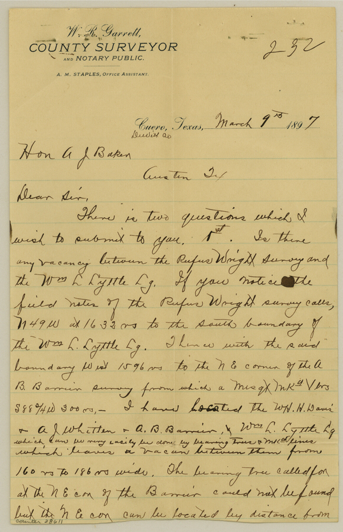
[Letter regarding vacancy between Rufus Wright and William L. Lyttle surveys in DeWitt County]
-
Map/Doc
28611
-
Collection
General Map Collection
-
Object Dates
3/9/1897 (Creation Date)
1858 (Survey Date)
1883 (Survey Date)
-
People and Organizations
W.R. Garrett (Surveyor/Engineer)
C.G. Hartman (Surveyor/Engineer)
-
Counties
DeWitt
-
Subjects
Surveying Sketch File
-
Height x Width
9.7 x 6.3 inches
24.6 x 16.0 cm
-
Medium
paper, manuscript
-
Features
Helena and Yorktown Road
Cabeza Creek
Part of: General Map Collection
Wilbarger County Working Sketch 19

Print $20.00
- Digital $50.00
Wilbarger County Working Sketch 19
1972
Size 36.6 x 38.3 inches
Map/Doc 72557
Part of Laguna Madre in Cameron County, showing Subdivision for Mineral Development

Print $20.00
- Digital $50.00
Part of Laguna Madre in Cameron County, showing Subdivision for Mineral Development
1963
Size 45.8 x 36.0 inches
Map/Doc 1926
Kimble County Rolled Sketch 44

Print $20.00
- Digital $50.00
Kimble County Rolled Sketch 44
Size 35.9 x 24.2 inches
Map/Doc 96810
Boundary Between the United States & Mexico Agreed Upon by the Joint Commission under the Treaty of Guadalupe Hidalgo

Print $20.00
- Digital $50.00
Boundary Between the United States & Mexico Agreed Upon by the Joint Commission under the Treaty of Guadalupe Hidalgo
1853
Size 24.0 x 18.3 inches
Map/Doc 65396
Edwards County Working Sketch 126

Print $20.00
- Digital $50.00
Edwards County Working Sketch 126
1980
Size 33.5 x 47.0 inches
Map/Doc 69002
Red River County

Print $40.00
- Digital $50.00
Red River County
1934
Size 52.0 x 41.3 inches
Map/Doc 66995
Briscoe County Rolled Sketch 17

Print $20.00
- Digital $50.00
Briscoe County Rolled Sketch 17
1946
Size 36.7 x 28.7 inches
Map/Doc 5331
Right of Way and Track Map of The Missouri, Kansas & Texas Railway of Texas

Print $40.00
- Digital $50.00
Right of Way and Track Map of The Missouri, Kansas & Texas Railway of Texas
1918
Size 24.8 x 52.6 inches
Map/Doc 64529
Maverick County Working Sketch 21

Print $20.00
- Digital $50.00
Maverick County Working Sketch 21
1977
Size 34.6 x 24.0 inches
Map/Doc 70913
Kerr County Sketch File 11

Print $4.00
- Digital $50.00
Kerr County Sketch File 11
1889
Size 14.2 x 8.7 inches
Map/Doc 28879
Webb County Sketch File X

Print $32.00
- Digital $50.00
Webb County Sketch File X
1908
Size 11.2 x 9.0 inches
Map/Doc 39701

You may also like
Hutchinson County Working Sketch 28

Print $20.00
- Digital $50.00
Hutchinson County Working Sketch 28
1978
Size 27.1 x 23.1 inches
Map/Doc 66388
University Land, El Paso County

Print $20.00
- Digital $50.00
University Land, El Paso County
1906
Size 25.1 x 31.4 inches
Map/Doc 2428
Flight Mission No. CUG-1P, Frame 83, Kleberg County

Print $20.00
- Digital $50.00
Flight Mission No. CUG-1P, Frame 83, Kleberg County
1956
Size 18.5 x 22.2 inches
Map/Doc 86148
Kleberg County Rolled Sketch 10-24

Print $20.00
- Digital $50.00
Kleberg County Rolled Sketch 10-24
1952
Size 41.7 x 36.0 inches
Map/Doc 9386
General Highway Map, Shelby County, Texas

Print $20.00
General Highway Map, Shelby County, Texas
1940
Size 18.3 x 24.8 inches
Map/Doc 79242
Cooke County Working Sketch 1

Print $20.00
- Digital $50.00
Cooke County Working Sketch 1
Size 16.5 x 28.3 inches
Map/Doc 68238
Flight Mission No. BRA-9M, Frame 77, Jefferson County

Print $20.00
- Digital $50.00
Flight Mission No. BRA-9M, Frame 77, Jefferson County
1953
Size 18.5 x 22.4 inches
Map/Doc 85660
Bailey County Working Sketch 3

Print $20.00
- Digital $50.00
Bailey County Working Sketch 3
1922
Size 17.3 x 28.0 inches
Map/Doc 67590
Shelby County Working Sketch 23b

Print $20.00
- Digital $50.00
Shelby County Working Sketch 23b
1983
Size 36.6 x 24.7 inches
Map/Doc 63877


Map of La Salle County

Print $20.00
- Digital $50.00
Map of La Salle County
1877
Size 29.7 x 21.6 inches
Map/Doc 3796