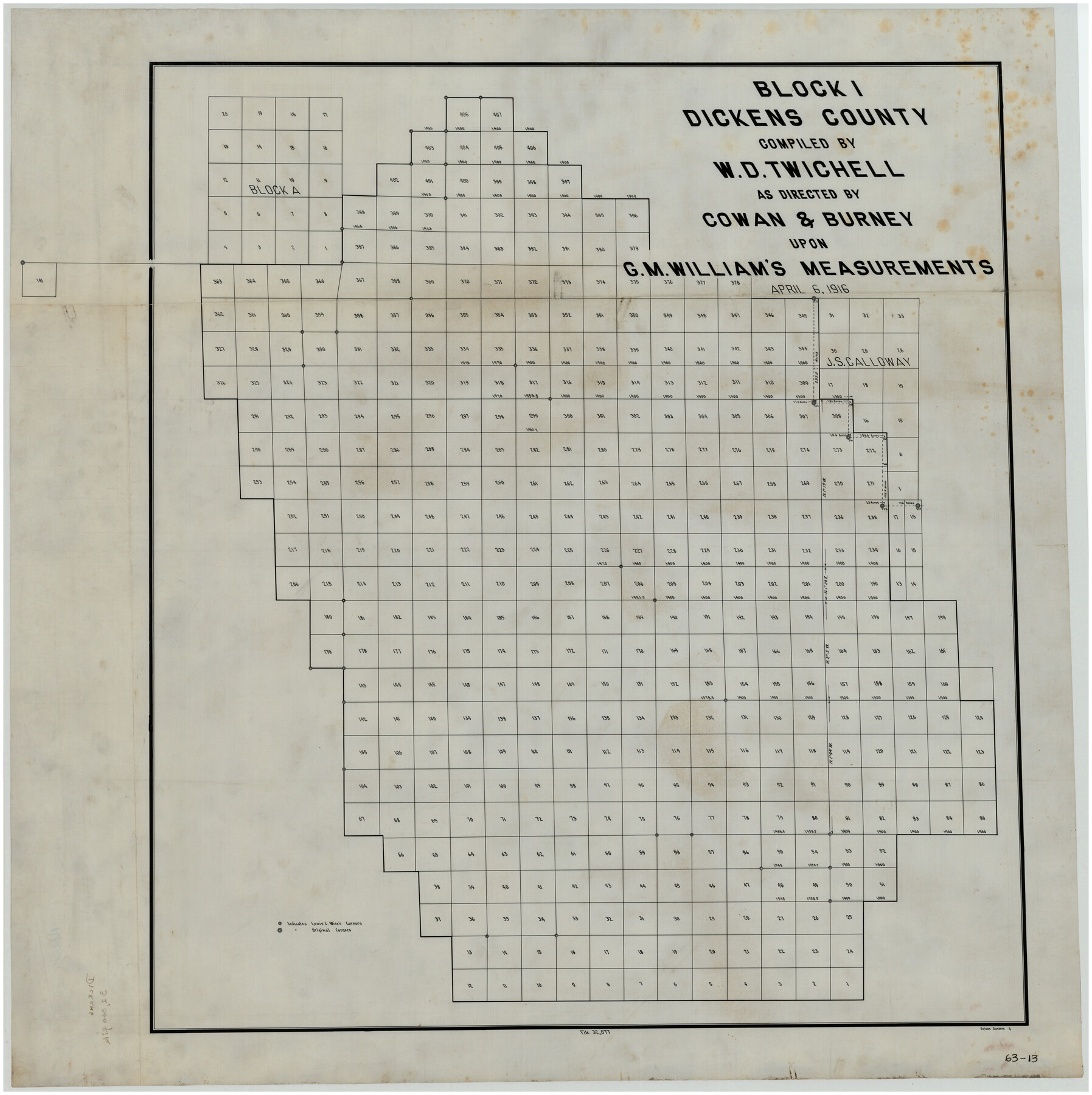
Block I, Dickens County Compiled by W.D. Twichell as directed by Cowan & Burney Upon G.M. Williams' Measurements
63-13
-
Map/Doc
89770
-
Collection
Twichell Survey Records
-
Object Dates
4/6/1916 (Creation Date)
-
Counties
Dickens
-
Height x Width
41.5 x 41.7 inches
105.4 x 105.9 cm
Part of: Twichell Survey Records
[Northwest part of County showing surveys along Spring Creek, Harvey Creek, and Red Hollow Creek]
![90909, [Northwest part of County showing surveys along Spring Creek, Harvey Creek, and Red Hollow Creek], Twichell Survey Records](https://historictexasmaps.com/wmedia_w700/maps/90909-1.tif.jpg)
Print $20.00
- Digital $50.00
[Northwest part of County showing surveys along Spring Creek, Harvey Creek, and Red Hollow Creek]
Size 18.5 x 14.4 inches
Map/Doc 90909
Wortham & Williams' Subdivisions of the San Augustine County School Leagues situated in Lubbock Co., Texas

Print $40.00
- Digital $50.00
Wortham & Williams' Subdivisions of the San Augustine County School Leagues situated in Lubbock Co., Texas
1909
Size 38.7 x 52.1 inches
Map/Doc 89935
[Blocks DT, P, CK, C2, and D7]
![91307, [Blocks DT, P, CK, C2, and D7], Twichell Survey Records](https://historictexasmaps.com/wmedia_w700/maps/91307-1.tif.jpg)
Print $20.00
- Digital $50.00
[Blocks DT, P, CK, C2, and D7]
Size 23.6 x 9.6 inches
Map/Doc 91307
Working Sketch Compiled From Original Field Notes Showing Surveys in Reagan and Irion Counties

Print $20.00
- Digital $50.00
Working Sketch Compiled From Original Field Notes Showing Surveys in Reagan and Irion Counties
Size 36.2 x 20.2 inches
Map/Doc 92331

Water Distribution Seagraves Located in Surveys 10 & 15, Block C-34

Print $20.00
- Digital $50.00
Water Distribution Seagraves Located in Surveys 10 & 15, Block C-34
Size 22.1 x 15.8 inches
Map/Doc 92899
[T. & P. Block 35, Townships 1N - 5N]
![93138, [T. & P. Block 35, Townships 1N - 5N], Twichell Survey Records](https://historictexasmaps.com/wmedia_w700/maps/93138-1.tif.jpg)
Print $40.00
- Digital $50.00
[T. & P. Block 35, Townships 1N - 5N]
Size 23.8 x 87.2 inches
Map/Doc 93138
[Sketch showing B. H. Epperson, Mary Fury and H. Rodgers surveys and vicinity]
![93069, [Sketch showing B. H. Epperson, Mary Fury and H. Rodgers surveys and vicinity], Twichell Survey Records](https://historictexasmaps.com/wmedia_w700/maps/93069-1.tif.jpg)
Print $20.00
- Digital $50.00
[Sketch showing B. H. Epperson, Mary Fury and H. Rodgers surveys and vicinity]
1919
Size 10.7 x 21.5 inches
Map/Doc 93069
[G. & M. Block 5]
![91782, [G. & M. Block 5], Twichell Survey Records](https://historictexasmaps.com/wmedia_w700/maps/91782-1.tif.jpg)
Print $20.00
- Digital $50.00
[G. & M. Block 5]
Size 31.8 x 26.6 inches
Map/Doc 91782
[Block XO3, Parts of Blocks Y2 and 1, and vicinity]
![91182, [Block XO3, Parts of Blocks Y2 and 1, and vicinity], Twichell Survey Records](https://historictexasmaps.com/wmedia_w700/maps/91182-1.tif.jpg)
Print $20.00
- Digital $50.00
[Block XO3, Parts of Blocks Y2 and 1, and vicinity]
Size 13.1 x 13.9 inches
Map/Doc 91182
Map of Public Roads in Terry County, Texas

Print $20.00
- Digital $50.00
Map of Public Roads in Terry County, Texas
Size 34.0 x 37.4 inches
Map/Doc 91936
[Sketch of sections 33 and 34]
![91574, [Sketch of sections 33 and 34], Twichell Survey Records](https://historictexasmaps.com/wmedia_w700/maps/91574-1.tif.jpg)
Print $2.00
- Digital $50.00
[Sketch of sections 33 and 34]
Size 5.1 x 8.8 inches
Map/Doc 91574
You may also like
Flight Mission No. BRE-4P, Frame 172, Nueces County

Print $20.00
- Digital $50.00
Flight Mission No. BRE-4P, Frame 172, Nueces County
1956
Size 18.4 x 22.1 inches
Map/Doc 86835
Hunt County, Texas

Print $20.00
- Digital $50.00
Hunt County, Texas
1871
Size 25.8 x 19.4 inches
Map/Doc 462
Pecos County Sketch File 74

Print $8.00
- Digital $50.00
Pecos County Sketch File 74
1941
Size 14.1 x 8.8 inches
Map/Doc 33900
Carson County Sketch File 6a

Print $10.00
- Digital $50.00
Carson County Sketch File 6a
1928
Size 14.1 x 8.4 inches
Map/Doc 17374
Nueces County Aerial Photograph Index Sheet 6

Print $20.00
- Digital $50.00
Nueces County Aerial Photograph Index Sheet 6
1956
Size 23.4 x 19.2 inches
Map/Doc 83739
Blanco County Rolled Sketch 5

Print $20.00
- Digital $50.00
Blanco County Rolled Sketch 5
Size 15.6 x 17.0 inches
Map/Doc 5143
Map of Caldwell Co.

Print $40.00
- Digital $50.00
Map of Caldwell Co.
1917
Size 48.4 x 43.0 inches
Map/Doc 89748
Ellwood Farms Situated in Hockley, Lamb, and Hale Counties, Texas

Print $20.00
- Digital $50.00
Ellwood Farms Situated in Hockley, Lamb, and Hale Counties, Texas
Size 20.3 x 30.1 inches
Map/Doc 92229
General Highway Map, Carson County, Texas

Print $20.00
General Highway Map, Carson County, Texas
1961
Size 18.2 x 24.9 inches
Map/Doc 79401
Panola County Working Sketch 31

Print $20.00
- Digital $50.00
Panola County Working Sketch 31
1981
Map/Doc 71440
Maverick County Sketch File 1 1/2

Print $20.00
- Digital $50.00
Maverick County Sketch File 1 1/2
1875
Size 23.2 x 27.6 inches
Map/Doc 12049
San Patricio County Sketch File 9

Print $2.00
- Digital $50.00
San Patricio County Sketch File 9
1846
Size 8.3 x 8.7 inches
Map/Doc 36039