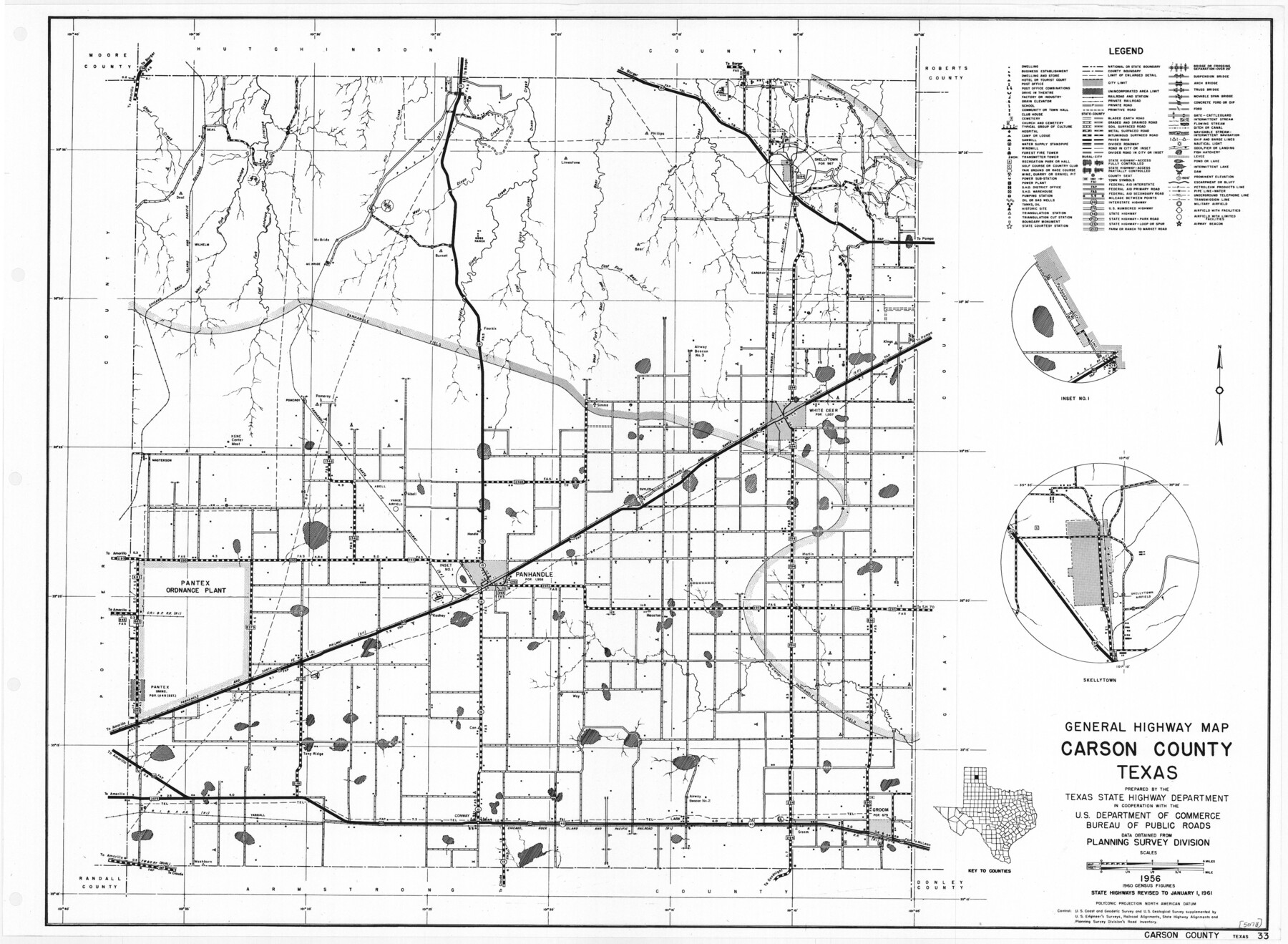
General Highway Map, Carson County, Texas
-
Map/Doc
79401
-
Collection
Texas State Library and Archives
-
Object Dates
1961 (Creation Date)
-
People and Organizations
Texas State Highway Department (Publisher)
-
Counties
Carson
-
Subjects
County
-
Height x Width
18.2 x 24.9 inches
46.2 x 63.3 cm
-
Comments
Prints available courtesy of the Texas State Library and Archives.
More info can be found here: TSLAC Map 05078
Part of: Texas State Library and Archives
General Highway Map. Detail of Cities and Towns in Dallas County, Texas [Dallas and vicinity]
![79434, General Highway Map. Detail of Cities and Towns in Dallas County, Texas [Dallas and vicinity], Texas State Library and Archives](https://historictexasmaps.com/wmedia_w700/maps/79434.tif.jpg)
Print $20.00
General Highway Map. Detail of Cities and Towns in Dallas County, Texas [Dallas and vicinity]
1961
Size 18.0 x 24.7 inches
Map/Doc 79434
General Highway Map, Henderson County, Texas

Print $20.00
General Highway Map, Henderson County, Texas
1961
Size 24.9 x 18.0 inches
Map/Doc 79517
General Highway Map, Angelina County, Texas

Print $20.00
General Highway Map, Angelina County, Texas
1961
Size 25.1 x 18.4 inches
Map/Doc 79350
General Highway Map, Wilson County, Texas

Print $20.00
General Highway Map, Wilson County, Texas
1961
Size 18.0 x 24.6 inches
Map/Doc 79715
General Highway Map, Reeves County, Texas

Print $20.00
General Highway Map, Reeves County, Texas
1940
Size 24.8 x 18.2 inches
Map/Doc 79227
General Highway Map, Liberty County, Texas

Print $20.00
General Highway Map, Liberty County, Texas
1961
Size 18.2 x 24.7 inches
Map/Doc 79570
General Highway Map, Atascosa County, Texas

Print $20.00
General Highway Map, Atascosa County, Texas
1940
Size 18.2 x 24.9 inches
Map/Doc 79008
General Highway Map, Freestone County, Texas

Print $20.00
General Highway Map, Freestone County, Texas
1961
Size 18.1 x 24.8 inches
Map/Doc 79472
Karte von Texas entworfen nach den Vermessungen, welche in den Acten der General-Land-Office der Republic liegen bis zum Jahr 1839 von Richard S. Hunt & Jesse F. Randel

Print $20.00
Karte von Texas entworfen nach den Vermessungen, welche in den Acten der General-Land-Office der Republic liegen bis zum Jahr 1839 von Richard S. Hunt & Jesse F. Randel
1841
Size 19.6 x 14.6 inches
Map/Doc 79311
General Highway Map, Aransas County, Texas

Print $20.00
General Highway Map, Aransas County, Texas
1961
Size 18.3 x 25.0 inches
Map/Doc 79352
General Highway Map, Leon County, Texas

Print $20.00
General Highway Map, Leon County, Texas
1961
Size 18.3 x 24.8 inches
Map/Doc 79568
General Highway Map, Hidalgo County, Texas

Print $20.00
General Highway Map, Hidalgo County, Texas
1961
Size 18.1 x 24.9 inches
Map/Doc 79518
You may also like
Cooke County Sketch File 24

Print $6.00
- Digital $50.00
Cooke County Sketch File 24
1871
Size 10.3 x 8.3 inches
Map/Doc 19272
[Geo. W. Woodley, W. B. Ralls, Boyd Bros. and surrounding surveys]
![90455, [Geo. W. Woodley, W. B. Ralls, Boyd Bros. and surrounding surveys], Twichell Survey Records](https://historictexasmaps.com/wmedia_w700/maps/90455-1.tif.jpg)
Print $3.00
- Digital $50.00
[Geo. W. Woodley, W. B. Ralls, Boyd Bros. and surrounding surveys]
Size 11.7 x 12.6 inches
Map/Doc 90455
Flight Mission No. DAH-9M, Frame 158, Orange County

Print $20.00
- Digital $50.00
Flight Mission No. DAH-9M, Frame 158, Orange County
1953
Size 18.4 x 22.3 inches
Map/Doc 86857

Grayson County Boundary File 1a

Print $120.00
- Digital $50.00
Grayson County Boundary File 1a
Size 69.3 x 11.3 inches
Map/Doc 53928
Tom Green County Sketch File 86

Print $8.00
- Digital $50.00
Tom Green County Sketch File 86
1986
Size 14.2 x 8.9 inches
Map/Doc 38260
Donley County Sketch File B3

Print $20.00
- Digital $50.00
Donley County Sketch File B3
1918
Size 22.0 x 15.0 inches
Map/Doc 11373
Anderson County Working Sketch 10

Print $20.00
- Digital $50.00
Anderson County Working Sketch 10
1933
Size 31.0 x 48.5 inches
Map/Doc 67009

Henderson County

Print $20.00
- Digital $50.00
Henderson County
1856
Size 17.9 x 29.2 inches
Map/Doc 3664
Fort Worth, Tex. "The Queen of the Prairies," County Seat of Tarrant County

Print $20.00
Fort Worth, Tex. "The Queen of the Prairies," County Seat of Tarrant County
1886
Size 26.0 x 33.3 inches
Map/Doc 89082
Subdivisions of Capitol Leagues 112, 113, 114, 115, and parts of 110 and 111

Print $2.00
- Digital $50.00
Subdivisions of Capitol Leagues 112, 113, 114, 115, and parts of 110 and 111
1906
Size 6.3 x 8.3 inches
Map/Doc 90518