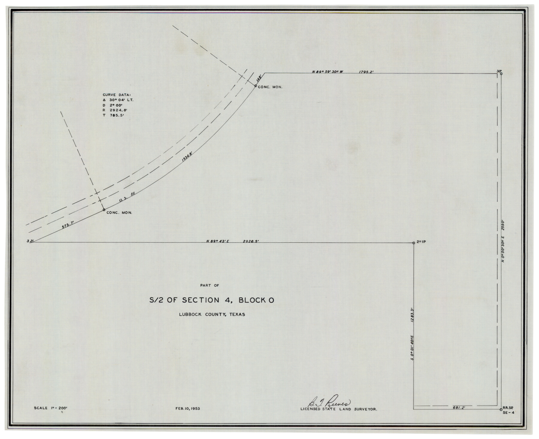
Part of South Half of Section 4, Block O
-
Map/Doc
92780
-
Collection
Twichell Survey Records
-
Object Dates
2/10/1953 (Creation Date)
-
People and Organizations
B.T. Reeves (Surveyor/Engineer)
-
Counties
Lubbock
-
Height x Width
21.1 x 17.2 inches
53.6 x 43.7 cm
Part of: Twichell Survey Records
Winkler Co., Tex., standard single county oil development survey

Print $20.00
- Digital $50.00
Winkler Co., Tex., standard single county oil development survey
Size 14.5 x 16.4 inches
Map/Doc 91972
[Sketch showing G. C. & S.F. Block S, T. T. RR. Co. Block H1, G. & M. Block M19, Block Z3 and Block 8]
![93122, [Sketch showing G. C. & S.F. Block S, T. T. RR. Co. Block H1, G. & M. Block M19, Block Z3 and Block 8], Twichell Survey Records](https://historictexasmaps.com/wmedia_w700/maps/93122-1.tif.jpg)
Print $40.00
- Digital $50.00
[Sketch showing G. C. & S.F. Block S, T. T. RR. Co. Block H1, G. & M. Block M19, Block Z3 and Block 8]
Size 43.7 x 52.8 inches
Map/Doc 93122
Water Plant for E. C. Stovall, South Bend, Texas

Print $20.00
- Digital $50.00
Water Plant for E. C. Stovall, South Bend, Texas
1914
Size 37.1 x 24.6 inches
Map/Doc 92142
[Northwest Quarter of County]
![91077, [Northwest Quarter of County], Twichell Survey Records](https://historictexasmaps.com/wmedia_w700/maps/91077-1.tif.jpg)
Print $20.00
- Digital $50.00
[Northwest Quarter of County]
1914
Size 18.6 x 25.7 inches
Map/Doc 91077
[Blocks H, Z, Rodriguez League, and vicinity]
![91174, [Blocks H, Z, Rodriguez League, and vicinity], Twichell Survey Records](https://historictexasmaps.com/wmedia_w700/maps/91174-1.tif.jpg)
Print $20.00
- Digital $50.00
[Blocks H, Z, Rodriguez League, and vicinity]
Size 20.5 x 26.1 inches
Map/Doc 91174
Ownership Map Hockley County, Texas

Print $20.00
- Digital $50.00
Ownership Map Hockley County, Texas
Size 19.1 x 20.4 inches
Map/Doc 92208
Map of State University Land, Pecos County, Texas

Print $20.00
- Digital $50.00
Map of State University Land, Pecos County, Texas
1929
Size 42.1 x 33.5 inches
Map/Doc 91626
Eastern Heights Addition - Preliminary Plat Showing Subdivision of SW/4 of SW/4 - Sectin 5 Block O as Proposed by Mr. H. Sieber 38.43 Ac.

Print $20.00
- Digital $50.00
Eastern Heights Addition - Preliminary Plat Showing Subdivision of SW/4 of SW/4 - Sectin 5 Block O as Proposed by Mr. H. Sieber 38.43 Ac.
1952
Size 23.8 x 19.8 inches
Map/Doc 92811
[Blocks B16, B7, B15]
![93130, [Blocks B16, B7, B15], Twichell Survey Records](https://historictexasmaps.com/wmedia_w700/maps/93130-1.tif.jpg)
Print $40.00
- Digital $50.00
[Blocks B16, B7, B15]
Size 57.2 x 51.5 inches
Map/Doc 93130
Laneer vs. Bivins, Potter County, Texas

Print $20.00
- Digital $50.00
Laneer vs. Bivins, Potter County, Texas
Size 21.2 x 19.0 inches
Map/Doc 93101
T. & P. RR. Co. Township 1 South, Block 44

Print $20.00
- Digital $50.00
T. & P. RR. Co. Township 1 South, Block 44
Size 20.1 x 29.3 inches
Map/Doc 90901
Map of the Melvin, Blum and Blum Lands situated in Bailey County, Texas

Print $40.00
- Digital $50.00
Map of the Melvin, Blum and Blum Lands situated in Bailey County, Texas
Size 40.1 x 80.7 inches
Map/Doc 93148
You may also like
Newton County Working Sketch 23

Print $20.00
- Digital $50.00
Newton County Working Sketch 23
1952
Size 22.0 x 26.6 inches
Map/Doc 71269
[County School Land Leagues in Bailey County and Lamb County]
![90971, [County School Land Leagues in Bailey County and Lamb County], Twichell Survey Records](https://historictexasmaps.com/wmedia_w700/maps/90971-2.tif.jpg)
Print $3.00
- Digital $50.00
[County School Land Leagues in Bailey County and Lamb County]
1900
Size 10.9 x 16.6 inches
Map/Doc 90971
Lampasas County Boundary File 2

Print $4.00
- Digital $50.00
Lampasas County Boundary File 2
Size 13.8 x 8.8 inches
Map/Doc 56095
Orange County Boundary File 1

Print $4.00
- Digital $50.00
Orange County Boundary File 1
Size 9.7 x 6.3 inches
Map/Doc 57773
Flight Mission No. CRK-3P, Frame 178, Refugio County

Print $20.00
- Digital $50.00
Flight Mission No. CRK-3P, Frame 178, Refugio County
1956
Size 18.4 x 22.2 inches
Map/Doc 86925
Hopkins County Working Sketch Graphic Index

Print $20.00
- Digital $50.00
Hopkins County Working Sketch Graphic Index
1942
Size 40.6 x 38.7 inches
Map/Doc 76581
Texas-Oklahoma Paris Quadrangle

Print $20.00
- Digital $50.00
Texas-Oklahoma Paris Quadrangle
Size 22.3 x 18.4 inches
Map/Doc 75107
Upton County Rolled Sketch 59

Print $40.00
- Digital $50.00
Upton County Rolled Sketch 59
1994
Size 36.3 x 49.0 inches
Map/Doc 10638
Flight Mission No. CGI-4N, Frame 180, Cameron County

Print $20.00
- Digital $50.00
Flight Mission No. CGI-4N, Frame 180, Cameron County
1955
Size 18.5 x 22.3 inches
Map/Doc 84683
Travis County Working Sketch 25

Print $20.00
- Digital $50.00
Travis County Working Sketch 25
1948
Size 26.4 x 32.0 inches
Map/Doc 69409
Flight Mission No. DCL-6C, Frame 21, Kenedy County

Print $20.00
- Digital $50.00
Flight Mission No. DCL-6C, Frame 21, Kenedy County
1943
Size 18.7 x 22.5 inches
Map/Doc 85878
Collin County Sketch File 7

Print $40.00
- Digital $50.00
Collin County Sketch File 7
1852
Size 17.3 x 14.0 inches
Map/Doc 18866