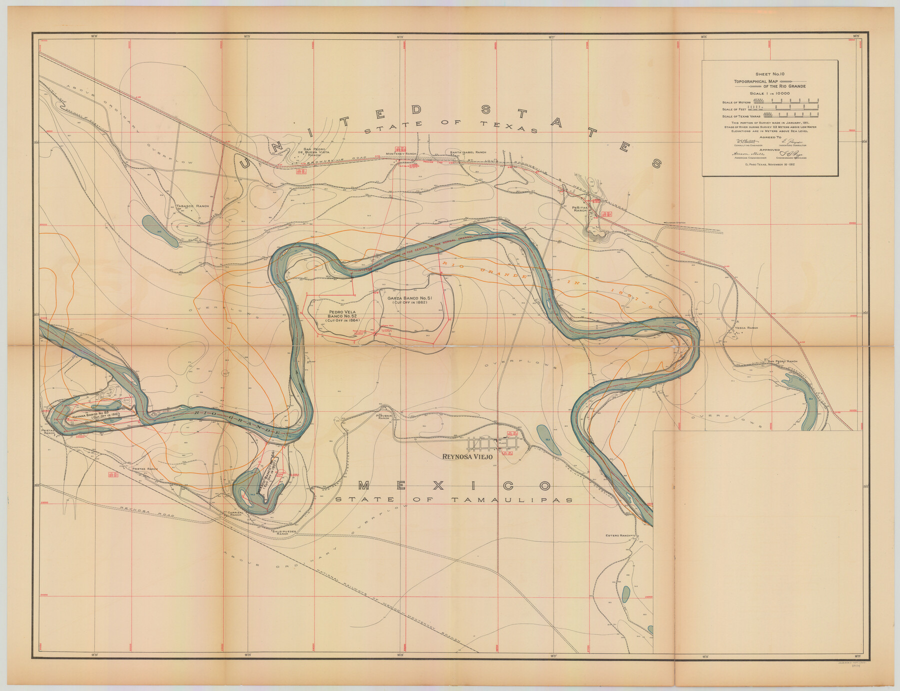
Topographical Map of the Rio Grande, Sheet No. 10
[from book: "Survey of the Rio Grande, Roma to the Gulf of Mexico, Reports and Maps"]
-
Map/Doc
89534
-
Collection
General Map Collection
-
Object Dates
1912/11/16 (Creation Date)
-
People and Organizations
International Boundary Commission (Publisher)
Anson Mills (Author)
E. Zayas (Surveyor/Engineer)
F.B. Puga (Author)
W.W. Follett (Surveyor/Engineer)
-
Subjects
River Surveys Texas Boundaries Topographic
-
Medium
paper
-
Scale
1:10000
-
Comments
This portion of the survey made in January, 1911. State of river during survey 0.3 meters above low water. Elevations are in meters above sea level. This map and 31 others were originally folded and bound into a book titled "Survey of the Rio Grande,
Part of: General Map Collection
Stonewall County Working Sketch 22

Print $20.00
- Digital $50.00
Stonewall County Working Sketch 22
1966
Size 44.2 x 32.9 inches
Map/Doc 62329
Flight Mission No. DAG-23K, Frame 14, Matagorda County

Print $20.00
- Digital $50.00
Flight Mission No. DAG-23K, Frame 14, Matagorda County
1953
Size 15.6 x 15.5 inches
Map/Doc 86476
Floyd County Sketch File 32

Print $8.00
- Digital $50.00
Floyd County Sketch File 32
1952
Size 14.3 x 8.9 inches
Map/Doc 22792
Bexar County State Real Property Sketch 6

Print $20.00
Bexar County State Real Property Sketch 6
2006
Size 22.2 x 33.1 inches
Map/Doc 96980
Flight Mission No. BRA-7M, Frame 141, Jefferson County

Print $20.00
- Digital $50.00
Flight Mission No. BRA-7M, Frame 141, Jefferson County
1953
Size 18.6 x 22.4 inches
Map/Doc 85535
Dimmit County Working Sketch 47
Print $40.00
- Digital $50.00
Dimmit County Working Sketch 47
1980
Size 71.3 x 43.8 inches
Map/Doc 68708

Live Oak County Sketch File 11a

Print $4.00
- Digital $50.00
Live Oak County Sketch File 11a
1876
Size 12.7 x 8.3 inches
Map/Doc 30265

Map of Caldwell County

Print $20.00
- Digital $50.00
Map of Caldwell County
1871
Size 16.9 x 19.9 inches
Map/Doc 4591
Map of Goliad County Texas

Print $20.00
- Digital $50.00
Map of Goliad County Texas
1879
Size 19.1 x 21.2 inches
Map/Doc 3589
Cameron County Rolled Sketch 25

Print $20.00
- Digital $50.00
Cameron County Rolled Sketch 25
1977
Size 24.6 x 36.7 inches
Map/Doc 5796
You may also like
Upton County Working Sketch 27

Print $20.00
- Digital $50.00
Upton County Working Sketch 27
1954
Size 24.2 x 33.9 inches
Map/Doc 69523
Goliad County Working Sketch Graphic Index

Print $20.00
- Digital $50.00
Goliad County Working Sketch Graphic Index
1946
Size 42.2 x 44.9 inches
Map/Doc 76555
Freestone County

Print $20.00
- Digital $50.00
Freestone County
1918
Size 46.8 x 39.8 inches
Map/Doc 4702
Topographic Map of Texas and Oklahoma Boundary, Fort Augur Area

Print $20.00
Topographic Map of Texas and Oklahoma Boundary, Fort Augur Area
1924
Size 17.2 x 33.7 inches
Map/Doc 79754
Flight Mission No. DQO-1K, Frame 156, Galveston County

Print $20.00
- Digital $50.00
Flight Mission No. DQO-1K, Frame 156, Galveston County
1952
Size 18.8 x 22.4 inches
Map/Doc 85009
General Highway Map, Madison County, Texas

Print $20.00
General Highway Map, Madison County, Texas
1961
Size 18.1 x 24.6 inches
Map/Doc 79581
[International & Great Northern Railroad, from Troupe to Overton]
![64388, [International & Great Northern Railroad, from Troupe to Overton], General Map Collection](https://historictexasmaps.com/wmedia_w700/maps/64388.tif.jpg)
Print $20.00
- Digital $50.00
[International & Great Northern Railroad, from Troupe to Overton]
1903
Size 25.1 x 38.4 inches
Map/Doc 64388
San Augustine County, Texas

Print $20.00
- Digital $50.00
San Augustine County, Texas
1879
Size 22.7 x 17.5 inches
Map/Doc 752
Carta geográfica que comprende en su extensión mucha parte del arzobispado de México, y alguna de los obispados de Puebla, Valladolid de Michoacán, Guadalajara y Durango, confinantes entre si

Carta geográfica que comprende en su extensión mucha parte del arzobispado de México, y alguna de los obispados de Puebla, Valladolid de Michoacán, Guadalajara y Durango, confinantes entre si
1779
Size 33.9 x 22.0 inches
Map/Doc 97079
Pecos County Sketch File 34

Print $4.00
- Digital $50.00
Pecos County Sketch File 34
Size 11.1 x 8.5 inches
Map/Doc 33714
Right of Way & Track Map, St. Louis, Brownsville & Mexico Ry. operated by St. Louis, Brownsville & Mexico Ry. Co.

Print $40.00
- Digital $50.00
Right of Way & Track Map, St. Louis, Brownsville & Mexico Ry. operated by St. Louis, Brownsville & Mexico Ry. Co.
1919
Size 25.5 x 57.1 inches
Map/Doc 64615
Bailey County Sketch File 21

Print $14.00
- Digital $50.00
Bailey County Sketch File 21
Size 11.3 x 8.8 inches
Map/Doc 13990