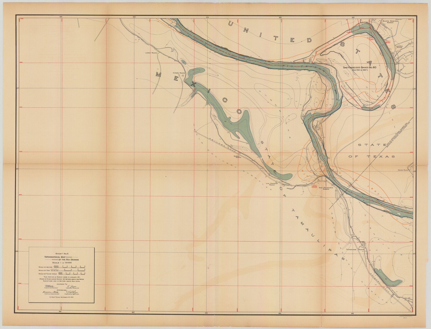
Topographical Map of the Rio Grande, Sheet No. 5
[from book: "Survey of the Rio Grande, Roma to the Gulf of Mexico, Reports and Maps"]
-
Map/Doc
89529
-
Collection
General Map Collection
-
Object Dates
1912/11/16 (Creation Date)
-
People and Organizations
International Boundary Commission (Publisher)
Anson Mills (Author)
E. Zayas (Surveyor/Engineer)
F.B. Puga (Author)
W.W. Follett (Surveyor/Engineer)
-
Subjects
River Surveys Texas Boundaries Topographic
-
Medium
paper
-
Scale
1:10000
-
Comments
This portion of the survey made in January, 1911. State of river during survey 0.2 meters above low water. Elevations are in meters above sea level. This map and 31 others were originally folded and bound into a book titled "Survey of the Rio Grande,
Part of: General Map Collection
Jones County Sketch File 1

Print $20.00
- Digital $50.00
Jones County Sketch File 1
1857
Size 17.8 x 30.3 inches
Map/Doc 11894
Harris County Historic Topographic 19

Print $20.00
- Digital $50.00
Harris County Historic Topographic 19
1915
Size 29.3 x 22.6 inches
Map/Doc 65830
Eastland County Boundary File 13

Print $68.00
- Digital $50.00
Eastland County Boundary File 13
Size 8.0 x 3.7 inches
Map/Doc 52785
Flight Mission No. DQO-3K, Frame 38, Galveston County

Print $20.00
- Digital $50.00
Flight Mission No. DQO-3K, Frame 38, Galveston County
1952
Size 18.7 x 22.3 inches
Map/Doc 85079
Karnes County Boundary File 3

Print $26.00
- Digital $50.00
Karnes County Boundary File 3
Size 12.7 x 8.3 inches
Map/Doc 55694
Gaines County Sketch File 20

Print $12.00
- Digital $50.00
Gaines County Sketch File 20
1906
Size 7.1 x 8.9 inches
Map/Doc 23335
Flight Mission No. CGI-3N, Frame 67, Cameron County

Print $20.00
- Digital $50.00
Flight Mission No. CGI-3N, Frame 67, Cameron County
1954
Size 18.5 x 22.2 inches
Map/Doc 84561
Walker County Working Sketch 4

Print $20.00
- Digital $50.00
Walker County Working Sketch 4
1934
Size 34.9 x 29.7 inches
Map/Doc 72284
Brazos County Working Sketch 1

Print $20.00
- Digital $50.00
Brazos County Working Sketch 1
1911
Size 26.5 x 16.3 inches
Map/Doc 67476
Polk County Working Sketch 6

Print $20.00
- Digital $50.00
Polk County Working Sketch 6
1933
Size 22.8 x 32.7 inches
Map/Doc 71621
[Map of Burnet County]
![4512, [Map of Burnet County], General Map Collection](https://historictexasmaps.com/wmedia_w700/maps/4512-2.tif.jpg)
Print $20.00
- Digital $50.00
[Map of Burnet County]
1856
Size 26.3 x 23.1 inches
Map/Doc 4512
Shackelford County Sketch File 4

Print $40.00
- Digital $50.00
Shackelford County Sketch File 4
Size 38.5 x 53.7 inches
Map/Doc 10600
You may also like
Williamson County Sketch File 20

Print $4.00
- Digital $50.00
Williamson County Sketch File 20
Size 8.2 x 12.9 inches
Map/Doc 40348
The Republic County of Harrison. December 29, 1845

Print $20.00
The Republic County of Harrison. December 29, 1845
2020
Size 18.6 x 21.7 inches
Map/Doc 96177
Topographical Map of the country between San Antonio & Colorado Rivers in the State of Texas.

Print $40.00
Topographical Map of the country between San Antonio & Colorado Rivers in the State of Texas.
1864
Size 53.4 x 69.8 inches
Map/Doc 88605
Austin County Sketch File 14

Print $40.00
- Digital $50.00
Austin County Sketch File 14
Size 18.8 x 8.8 inches
Map/Doc 13880
Andrews County

Print $20.00
- Digital $50.00
Andrews County
1887
Size 22.8 x 25.8 inches
Map/Doc 3230
Medina County Rolled Sketch 22

Print $20.00
- Digital $50.00
Medina County Rolled Sketch 22
2007
Size 24.5 x 18.4 inches
Map/Doc 88849
Coryell County, Texas

Print $20.00
- Digital $50.00
Coryell County, Texas
1879
Size 23.5 x 29.1 inches
Map/Doc 704
Van Zandt County Sketch File 29c

Print $4.00
- Digital $50.00
Van Zandt County Sketch File 29c
1861
Size 8.2 x 8.3 inches
Map/Doc 39459
Hockley County Map

Print $20.00
- Digital $50.00
Hockley County Map
Size 20.4 x 21.4 inches
Map/Doc 91195
Wise County Working Sketch 22

Print $20.00
- Digital $50.00
Wise County Working Sketch 22
1980
Size 28.1 x 27.8 inches
Map/Doc 72636
Southern Pacific Lines in Texas and Louisiana (G. H. & S. A. Ry.) Circuit Plan of Automatic Block Signals, Automatic Train Control and Flatonia Interlocking Plant No. 3

Print $40.00
- Digital $50.00
Southern Pacific Lines in Texas and Louisiana (G. H. & S. A. Ry.) Circuit Plan of Automatic Block Signals, Automatic Train Control and Flatonia Interlocking Plant No. 3
1927
Size 43.5 x 215.5 inches
Map/Doc 90044
Wilbarger County Working Sketch 6

Print $20.00
- Digital $50.00
Wilbarger County Working Sketch 6
1946
Size 27.1 x 41.4 inches
Map/Doc 72544