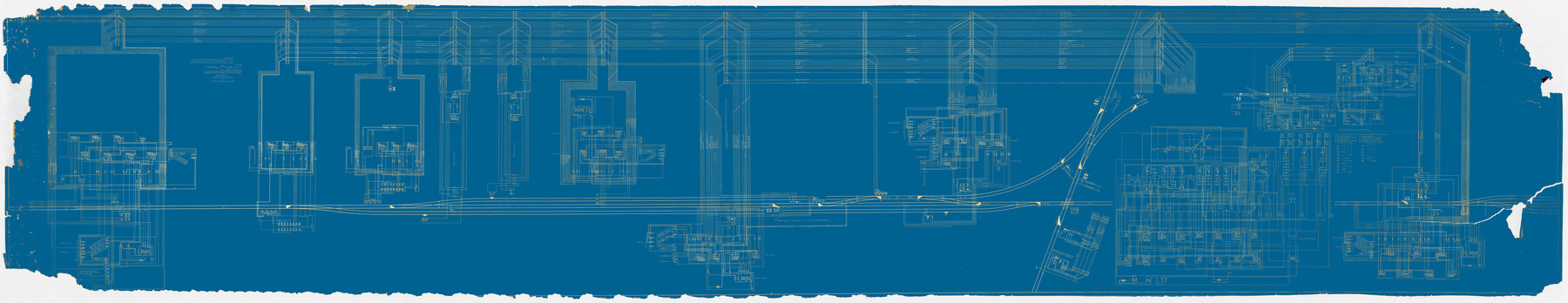
Southern Pacific Lines in Texas and Louisiana (G. H. & S. A. Ry.) Circuit Plan of Automatic Block Signals, Automatic Train Control and Flatonia Interlocking Plant No. 3
-
Map/Doc
90044
-
Collection
General Map Collection
-
Object Dates
10/15/1927 (Creation Date)
-
People and Organizations
Office of Signal Engineers (Author)
-
Subjects
Railroads
-
Height x Width
43.5 x 215.5 inches
110.5 x 547.4 cm
-
Medium
blueprint
-
Comments
Southern Pacific's Construction Diagram/Blue Print of the original physical plant (Signal and Communications) "Tower" in Flatonia, Texas. The Tower is no longer in service but has been relocated within Flatonia to archive its memory and historical signifi
Part of: General Map Collection
Sutton County Working Sketch 25

Print $40.00
- Digital $50.00
Sutton County Working Sketch 25
Size 69.4 x 37.1 inches
Map/Doc 62368
Jones County Sketch File 7

Print $20.00
- Digital $50.00
Jones County Sketch File 7
Size 12.5 x 27.5 inches
Map/Doc 11897
Brewster County Rolled Sketch 98

Print $20.00
- Digital $50.00
Brewster County Rolled Sketch 98
1952
Size 29.3 x 38.0 inches
Map/Doc 8508
Wilbarger County Aerial Photograph Index Sheet 4

Print $20.00
- Digital $50.00
Wilbarger County Aerial Photograph Index Sheet 4
1950
Size 21.7 x 18.8 inches
Map/Doc 83753
Hays County Sketch File 16

Print $4.00
- Digital $50.00
Hays County Sketch File 16
1857
Size 12.8 x 8.3 inches
Map/Doc 26227
Kinney County Working Sketch 27

Print $20.00
- Digital $50.00
Kinney County Working Sketch 27
1956
Size 23.1 x 25.1 inches
Map/Doc 70209

Brazoria County Sketch File 26

Print $40.00
- Digital $50.00
Brazoria County Sketch File 26
Size 13.6 x 13.6 inches
Map/Doc 15028

Webb County Boundary File 1

Print $16.00
- Digital $50.00
Webb County Boundary File 1
Size 7.2 x 8.9 inches
Map/Doc 59695
Flight Mission No. CGI-3N, Frame 131, Cameron County

Print $20.00
- Digital $50.00
Flight Mission No. CGI-3N, Frame 131, Cameron County
1954
Size 18.7 x 22.3 inches
Map/Doc 84604
Crockett County Rolled Sketch RC1

Print $20.00
- Digital $50.00
Crockett County Rolled Sketch RC1
1935
Size 43.7 x 30.6 inches
Map/Doc 8701
You may also like
Burnet County Sketch File 11

Print $40.00
- Digital $50.00
Burnet County Sketch File 11
1848
Size 12.8 x 15.2 inches
Map/Doc 16692
Pecos County Rolled Sketch 124

Print $20.00
- Digital $50.00
Pecos County Rolled Sketch 124
Size 22.8 x 18.8 inches
Map/Doc 7265
Crosby County Working Sketch Graphic Index

Print $20.00
- Digital $50.00
Crosby County Working Sketch Graphic Index
1927
Size 41.8 x 37.4 inches
Map/Doc 76513
Bosque County Sketch File 12

Print $4.00
- Digital $50.00
Bosque County Sketch File 12
1863
Size 12.7 x 8.2 inches
Map/Doc 14761
Corpus Christi Harbor

Print $40.00
- Digital $50.00
Corpus Christi Harbor
1976
Size 37.1 x 51.5 inches
Map/Doc 73480
[Township 1 North, Range 17 East]
![90771, [Township 1 North, Range 17 East], Twichell Survey Records](https://historictexasmaps.com/wmedia_w700/maps/90771-1.tif.jpg)
Print $2.00
- Digital $50.00
[Township 1 North, Range 17 East]
Size 14.5 x 8.2 inches
Map/Doc 90771
Map of Robertson County

Print $20.00
- Digital $50.00
Map of Robertson County
1873
Size 28.0 x 21.6 inches
Map/Doc 83003
Ward County Boundary File 1

Print $12.00
- Digital $50.00
Ward County Boundary File 1
Size 14.4 x 9.0 inches
Map/Doc 59667
Texas Gulf Coast Map from the Sabine River to the Rio Grande as subdivided for mineral development

Print $40.00
- Digital $50.00
Texas Gulf Coast Map from the Sabine River to the Rio Grande as subdivided for mineral development
1948
Size 44.0 x 69.2 inches
Map/Doc 2908
Calhoun County Rolled Sketch 28B

Print $7.00
- Digital $50.00
Calhoun County Rolled Sketch 28B
1834
Size 10.5 x 15.4 inches
Map/Doc 43684
New Map of Texas prepared and published for the Bureau of Immigration of the State of Texas

Print $20.00
- Digital $50.00
New Map of Texas prepared and published for the Bureau of Immigration of the State of Texas
1875
Size 15.8 x 18.3 inches
Map/Doc 93625
Oldham County Working Sketch 5

Print $40.00
- Digital $50.00
Oldham County Working Sketch 5
1951
Size 43.0 x 59.3 inches
Map/Doc 71327