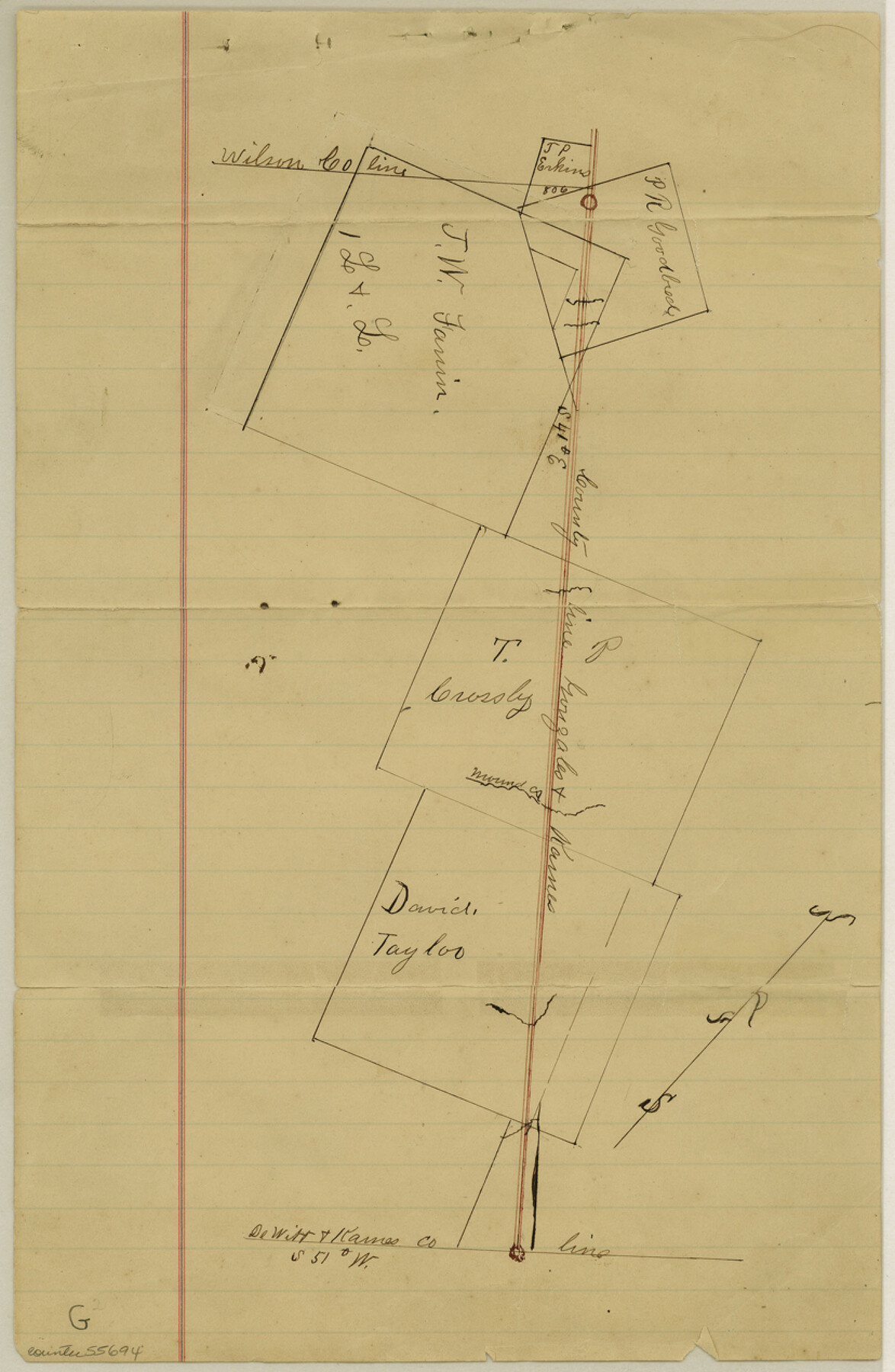
Karnes County Boundary File 3
[Court Order, Surveyor's Report and Sketch of Boundary line between Karnes and Gonzales Counties]
-
Map/Doc
55694
-
Collection
General Map Collection
-
Counties
Karnes
-
Subjects
County Boundaries
-
Height x Width
12.7 x 8.3 inches
32.3 x 21.1 cm
Part of: General Map Collection
Gray County Rolled Sketch A

Print $20.00
- Digital $50.00
Gray County Rolled Sketch A
1888
Size 40.4 x 40.8 inches
Map/Doc 9008

Crockett County Sketch File 44

Print $8.00
- Digital $50.00
Crockett County Sketch File 44
1881
Size 12.8 x 8.8 inches
Map/Doc 19768
Cooke County Sketch File 12

Print $4.00
- Digital $50.00
Cooke County Sketch File 12
Size 10.1 x 8.3 inches
Map/Doc 19246
Tarrant County Working Sketch 1

Print $20.00
- Digital $50.00
Tarrant County Working Sketch 1
1939
Size 12.2 x 18.9 inches
Map/Doc 62418
Moore County Rolled Sketch 4

Print $20.00
- Digital $50.00
Moore County Rolled Sketch 4
Size 21.1 x 12.1 inches
Map/Doc 6824
Webb County Working Sketch 39

Print $20.00
- Digital $50.00
Webb County Working Sketch 39
1941
Size 22.9 x 17.2 inches
Map/Doc 72404
[Aransas and Corpus Christi Bays]
![140, [Aransas and Corpus Christi Bays], General Map Collection](https://historictexasmaps.com/wmedia_w700/maps/140.tif.jpg)
Print $3.00
- Digital $50.00
[Aransas and Corpus Christi Bays]
1839
Size 11.4 x 16.5 inches
Map/Doc 140
Gulf Intracoastal Waterway - Aransas Bay to Corpus Christi Bay, Modified Route of Main Channel Location of Spoil Disposal Areas

Print $20.00
- Digital $50.00
Gulf Intracoastal Waterway - Aransas Bay to Corpus Christi Bay, Modified Route of Main Channel Location of Spoil Disposal Areas
1961
Size 31.4 x 42.1 inches
Map/Doc 61829
San Jacinto County Rolled Sketch 10A

Print $40.00
- Digital $50.00
San Jacinto County Rolled Sketch 10A
1944
Size 42.9 x 59.0 inches
Map/Doc 9882
Map of Robertson District

Print $40.00
- Digital $50.00
Map of Robertson District
1846
Size 81.3 x 45.3 inches
Map/Doc 3032
Dimmit County Sketch File 31

Print $20.00
- Digital $50.00
Dimmit County Sketch File 31
1894
Size 12.7 x 17.3 inches
Map/Doc 11352
You may also like
Duval County Boundary File 3i

Print $4.00
- Digital $50.00
Duval County Boundary File 3i
Size 8.3 x 10.3 inches
Map/Doc 52751
Houston County Working Sketch 36

Print $40.00
- Digital $50.00
Houston County Working Sketch 36
1987
Size 61.2 x 43.6 inches
Map/Doc 78231
[Galveston, Harrisburg & San Antonio through El Paso County]
![64010, [Galveston, Harrisburg & San Antonio through El Paso County], General Map Collection](https://historictexasmaps.com/wmedia_w700/maps/64010.tif.jpg)
Print $20.00
- Digital $50.00
[Galveston, Harrisburg & San Antonio through El Paso County]
1906
Size 13.4 x 33.9 inches
Map/Doc 64010
Edwards County Working Sketch 37

Print $20.00
- Digital $50.00
Edwards County Working Sketch 37
1948
Size 23.1 x 35.5 inches
Map/Doc 68913
Frio County Sketch File 12

Print $18.00
- Digital $50.00
Frio County Sketch File 12
1938
Size 14.2 x 8.7 inches
Map/Doc 23127
Crockett County Sketch File 58a

Print $20.00
- Digital $50.00
Crockett County Sketch File 58a
1923
Size 21.1 x 25.8 inches
Map/Doc 5601
Map of the River Sabine from Logan's Ferry to 32nd degree of north latitude

Print $2.00
- Digital $50.00
Map of the River Sabine from Logan's Ferry to 32nd degree of north latitude
1841
Size 8.6 x 10.5 inches
Map/Doc 65388
Lavaca County Rolled Sketch 5

Print $40.00
- Digital $50.00
Lavaca County Rolled Sketch 5
Size 37.0 x 49.1 inches
Map/Doc 10288
North Shore of West Bay and Galveston Island

Print $40.00
- Digital $50.00
North Shore of West Bay and Galveston Island
1933
Size 36.4 x 56.9 inches
Map/Doc 69931
Comal County Sketch File 3

Print $8.00
- Digital $50.00
Comal County Sketch File 3
1853
Size 4.4 x 8.4 inches
Map/Doc 18999
Right of Way and Track Map of The Missouri, Kansas & Texas Railway of Texas

Print $40.00
- Digital $50.00
Right of Way and Track Map of The Missouri, Kansas & Texas Railway of Texas
1918
Size 25.3 x 56.1 inches
Map/Doc 64528
General Highway Map, Red River County, Texas

Print $20.00
General Highway Map, Red River County, Texas
1961
Size 24.6 x 18.1 inches
Map/Doc 79637