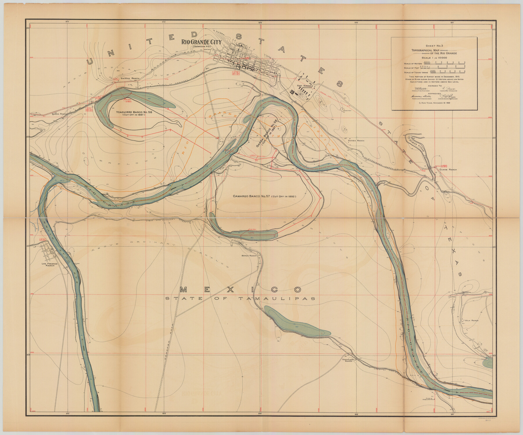
Topographical Map of the Rio Grande, Sheet No. 3
[from book: "Survey of the Rio Grande, Roma to the Gulf of Mexico, Reports and Maps"]
-
Map/Doc
89527
-
Collection
General Map Collection
-
Object Dates
1912/11/16 (Creation Date)
-
People and Organizations
International Boundary Commission (Publisher)
Anson Mills (Author)
E. Zayas (Surveyor/Engineer)
F.B. Puga (Author)
W.W. Follett (Surveyor/Engineer)
-
Subjects
River Surveys Texas Boundaries Topographic
-
Medium
paper
-
Scale
1:10000
-
Comments
This portion of the survey made in December 1910. State of river during survey 0.2 meters above low water. Elevations are in meters above sea level. This map and 31 others were originally folded and bound into a book titled "Survey of the Rio Grande,
Part of: General Map Collection
Moore County Working Sketch 12

Print $20.00
- Digital $50.00
Moore County Working Sketch 12
1952
Size 33.1 x 28.4 inches
Map/Doc 71194
Kimble County

Print $40.00
- Digital $50.00
Kimble County
1890
Size 39.2 x 57.5 inches
Map/Doc 78435
Winkler County Working Sketch 8

Print $20.00
- Digital $50.00
Winkler County Working Sketch 8
1958
Size 31.9 x 30.7 inches
Map/Doc 72602
Jeff Davis County Sketch File 3

Print $22.00
- Digital $50.00
Jeff Davis County Sketch File 3
Size 12.3 x 8.6 inches
Map/Doc 27892
Township 2 North Range 11 West, North Western District, Louisiana

Print $20.00
- Digital $50.00
Township 2 North Range 11 West, North Western District, Louisiana
1884
Size 19.7 x 24.7 inches
Map/Doc 65876
[Surveys in Austin County]
![35, [Surveys in Austin County], General Map Collection](https://historictexasmaps.com/wmedia_w700/maps/35.tif.jpg)
Print $20.00
- Digital $50.00
[Surveys in Austin County]
1840
Size 20.8 x 28.2 inches
Map/Doc 35
Cameron County Rolled Sketch 20E

Print $20.00
- Digital $50.00
Cameron County Rolled Sketch 20E
Size 12.9 x 11.4 inches
Map/Doc 5479
Kinney County Working Sketch 31

Print $20.00
- Digital $50.00
Kinney County Working Sketch 31
1961
Size 30.9 x 47.3 inches
Map/Doc 70213
Liberty County Working Sketch 69

Print $20.00
- Digital $50.00
Liberty County Working Sketch 69
1972
Size 29.8 x 41.8 inches
Map/Doc 70529
Oldham County

Print $40.00
- Digital $50.00
Oldham County
1925
Size 43.6 x 53.5 inches
Map/Doc 66960
Presidio County Sketch File 47

Print $16.00
- Digital $50.00
Presidio County Sketch File 47
1918
Size 7.2 x 8.1 inches
Map/Doc 34574
Shelby County Working Sketch 30

Print $20.00
- Digital $50.00
Shelby County Working Sketch 30
2000
Size 35.9 x 44.7 inches
Map/Doc 63885
You may also like

Jasper County Sketch File 32

Print $20.00
- Digital $50.00
Jasper County Sketch File 32
1906
Size 28.0 x 22.3 inches
Map/Doc 11853
Crockett County Sketch File 73

Print $6.00
- Digital $50.00
Crockett County Sketch File 73
1933
Size 11.2 x 8.7 inches
Map/Doc 19869
Bennett and Norman, 30 Acres

Print $20.00
- Digital $50.00
Bennett and Norman, 30 Acres
Size 27.9 x 9.7 inches
Map/Doc 92721
Moore County Working Sketch 14

Print $20.00
- Digital $50.00
Moore County Working Sketch 14
1972
Size 32.7 x 19.8 inches
Map/Doc 71196
Dimmit County Sketch File 58

Print $20.00
- Digital $50.00
Dimmit County Sketch File 58
1951
Size 18.0 x 9.8 inches
Map/Doc 11361
Parker County Sketch File 12

Print $4.00
- Digital $50.00
Parker County Sketch File 12
1858
Size 9.1 x 7.1 inches
Map/Doc 33544

[Titles along the Trinity River]
![175, [Titles along the Trinity River], General Map Collection](https://historictexasmaps.com/wmedia_w700/maps/175.tif.jpg)
Print $3.00
- Digital $50.00
[Titles along the Trinity River]
Size 10.6 x 15.8 inches
Map/Doc 175
Harris County Rolled Sketch O

Print $20.00
- Digital $50.00
Harris County Rolled Sketch O
1913
Size 16.0 x 24.5 inches
Map/Doc 6140
Sutton County Working Sketch 68

Print $40.00
- Digital $50.00
Sutton County Working Sketch 68
1972
Size 61.2 x 37.4 inches
Map/Doc 62411
Nueces County Rolled Sketch 50

Print $20.00
- Digital $50.00
Nueces County Rolled Sketch 50
1939
Size 21.9 x 38.0 inches
Map/Doc 9605