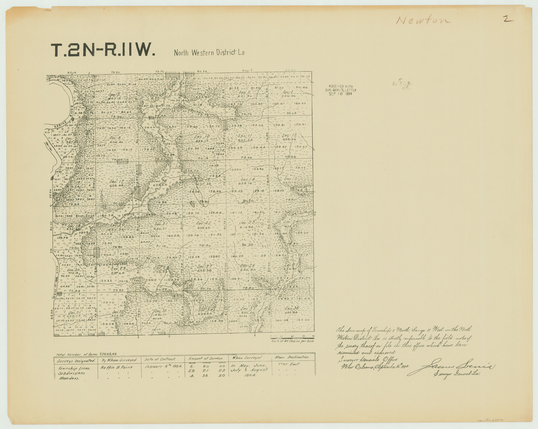
Township 2 North Range 11 West, North Western District, Louisiana
Louisiana Land Surveys Across From Newton County, Texas 2
-
Map/Doc
65876
-
Collection
General Map Collection
-
Object Dates
1884 (Creation Date)
-
People and Organizations
Surveyor General's Office Louisiana (Publisher)
Ruffin B. Paine (Surveyor/Engineer)
-
Subjects
Texas Boundaries
-
Height x Width
19.7 x 24.7 inches
50.0 x 62.7 cm
-
Comments
Surveyed in May, June, July, and August 1884.
Part of: General Map Collection
Montgomery County Rolled Sketch 31

Print $20.00
- Digital $50.00
Montgomery County Rolled Sketch 31
1949
Size 43.6 x 42.2 inches
Map/Doc 9539
[Surveys in the Bexar District along the Medina River]
![130, [Surveys in the Bexar District along the Medina River], General Map Collection](https://historictexasmaps.com/wmedia_w700/maps/130.tif.jpg)
Print $20.00
- Digital $50.00
[Surveys in the Bexar District along the Medina River]
1841
Size 20.7 x 12.8 inches
Map/Doc 130
Brazoria County Sketch File 47

Print $10.00
- Digital $50.00
Brazoria County Sketch File 47
Size 14.3 x 8.9 inches
Map/Doc 15106
Aransas County Sketch File 31

Print $46.00
- Digital $50.00
Aransas County Sketch File 31
1919
Size 14.2 x 8.7 inches
Map/Doc 13274
Coryell County

Print $20.00
- Digital $50.00
Coryell County
1936
Size 46.8 x 43.4 inches
Map/Doc 1810
Crockett County Working Sketch 68

Print $40.00
- Digital $50.00
Crockett County Working Sketch 68
1959
Size 23.7 x 55.6 inches
Map/Doc 68401
Glasscock County Working Sketch 11

Print $40.00
- Digital $50.00
Glasscock County Working Sketch 11
1957
Size 87.4 x 36.2 inches
Map/Doc 63184
Reagan County Rolled Sketch 9

Print $20.00
- Digital $50.00
Reagan County Rolled Sketch 9
1937
Size 29.7 x 30.9 inches
Map/Doc 7437
Texas Gulf Coast Map from the Sabine River to the Rio Grande as subdivided for mineral development

Print $40.00
- Digital $50.00
Texas Gulf Coast Map from the Sabine River to the Rio Grande as subdivided for mineral development
Size 117.9 x 46.0 inches
Map/Doc 2902
Hartley County Boundary File 5

Print $6.00
- Digital $50.00
Hartley County Boundary File 5
Size 12.7 x 8.2 inches
Map/Doc 54515
Cherokee County Working Sketch 7

Print $20.00
- Digital $50.00
Cherokee County Working Sketch 7
1954
Size 22.2 x 22.7 inches
Map/Doc 67962
Trinity County Working Sketch 4

Print $20.00
- Digital $50.00
Trinity County Working Sketch 4
1908
Size 21.3 x 18.5 inches
Map/Doc 69452
You may also like
Map of Liberty County

Print $20.00
- Digital $50.00
Map of Liberty County
Size 27.6 x 26.2 inches
Map/Doc 91079
Dimmit County Working Sketch 52

Print $20.00
- Digital $50.00
Dimmit County Working Sketch 52
1989
Size 25.2 x 37.0 inches
Map/Doc 68713
No. 3 Chart of Channel connecting Corpus Christi Bay with Aransas Bay, Texas

Print $20.00
- Digital $50.00
No. 3 Chart of Channel connecting Corpus Christi Bay with Aransas Bay, Texas
1878
Size 18.3 x 27.5 inches
Map/Doc 72784
Potter County Sketch File 3

Print $20.00
- Digital $50.00
Potter County Sketch File 3
1883
Size 37.5 x 47.6 inches
Map/Doc 10574
Colorado County Rolled Sketch 7

Print $20.00
- Digital $50.00
Colorado County Rolled Sketch 7
1997
Size 26.2 x 19.1 inches
Map/Doc 5534
Sabine River, West Extension Toll Bridge Sheet

Print $4.00
- Digital $50.00
Sabine River, West Extension Toll Bridge Sheet
1933
Size 15.2 x 19.3 inches
Map/Doc 65142
Trinity River, Reynard Sheet

Print $20.00
- Digital $50.00
Trinity River, Reynard Sheet
1925
Size 42.3 x 45.3 inches
Map/Doc 65181
Hunt County Sketch File 20

Print $4.00
- Digital $50.00
Hunt County Sketch File 20
1853
Size 8.3 x 7.9 inches
Map/Doc 27120
Liberty County Working Sketch 63

Print $20.00
- Digital $50.00
Liberty County Working Sketch 63
1969
Size 31.3 x 28.7 inches
Map/Doc 70523
Dimmit County

Print $40.00
- Digital $50.00
Dimmit County
1976
Size 43.2 x 50.7 inches
Map/Doc 73133
Packery Channel

Print $3.00
- Digital $50.00
Packery Channel
1972
Size 10.6 x 17.8 inches
Map/Doc 2999
Harris County Rolled Sketch 82

Print $40.00
- Digital $50.00
Harris County Rolled Sketch 82
1956
Size 50.5 x 36.4 inches
Map/Doc 9138