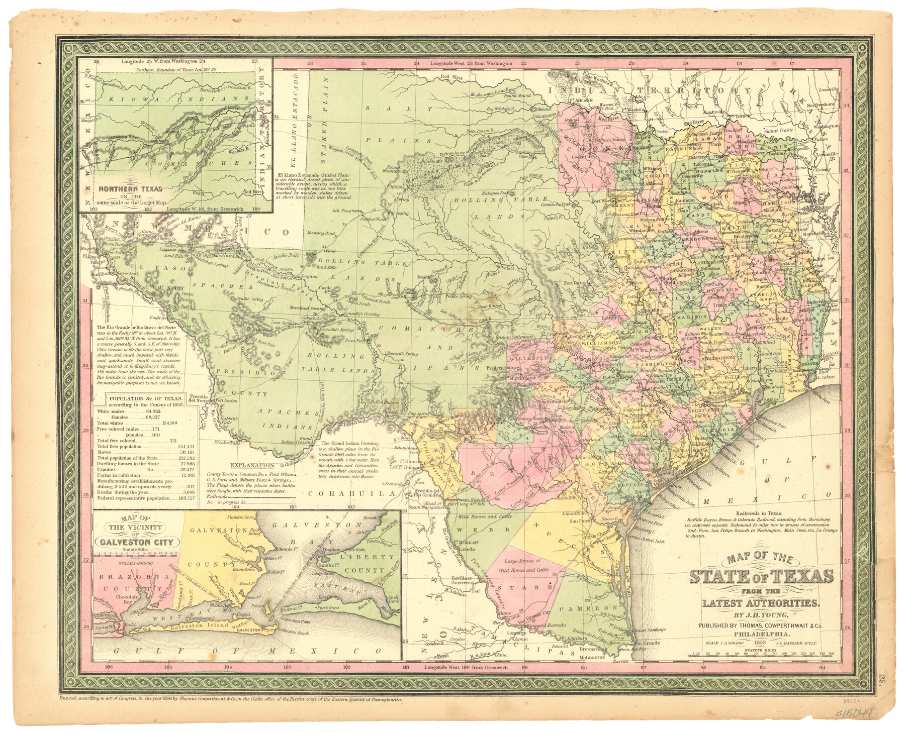
Map of the State of Texas from the Latest Authorities
- 
                          Map/Doc
89221
 - 
                            Collection
General Map Collection
 - 
                            Object Dates
1853 (Creation Date)
10/23/2009 (File Date)
 - 
                            People and Organizations
Thomas, Cowperthwait and Co. (Publisher)
J.H. Young (Author)
 - 
                            Subjects
State of Texas
 - 
                            Height x Width
14.2 x 17.4 inches
36.1 x 44.2 cm
 - 
                            Comments
Originally housed in an atlas, this map was one of the first to show the new boundaries of Texas after the Compromise of 1850.
 
Part of: General Map Collection
            Culberson County Rolled Sketch 39


                                            Print $20.00                    
                                             -                         Digital $50.00                                    
                Culberson County Rolled Sketch 39
Size 25.6 x 19.3 inches
                                Map/Doc 5783
            
            Henderson County Working Sketch 8


                                            Print $20.00                    
                                             -                         Digital $50.00                                    
                Henderson County Working Sketch 8
1922
Size 15.9 x 16.1 inches
                                Map/Doc 66141
            
            Kent County Boundary File 5


                                            Print $6.00                    
                                             -                         Digital $50.00                                    
                Kent County Boundary File 5
Size 8.6 x 8.6 inches
                                Map/Doc 55865
            
            Duval County Sketch File 35a


                                            Print $26.00                    
                                             -                         Digital $50.00                                    
                Duval County Sketch File 35a
Size 11.3 x 8.9 inches
                                Map/Doc 21371
            
            Pecos County Sketch File 114


                                            Print $18.00                    
                                             -                         Digital $50.00                                    
                Pecos County Sketch File 114
1912
Size 13.3 x 8.9 inches
                                Map/Doc 34074
            
            Val Verde County Sketch File 50


                                            Print $8.00                    
                                             -                         Digital $50.00                                    
                Val Verde County Sketch File 50
1956
Size 11.5 x 8.9 inches
                                Map/Doc 39316
            
            Van Zandt County Sketch File 22a


                                            Print $4.00                    
                                             -                         Digital $50.00                                    
                Van Zandt County Sketch File 22a
1858
Size 7.5 x 8.2 inches
                                Map/Doc 39435
            
            Kimble County Working Sketch 83


                                            Print $20.00                    
                                             -                         Digital $50.00                                    
                Kimble County Working Sketch 83
1971
Size 31.3 x 31.1 inches
                                Map/Doc 70151
            
            Travis County Working Sketch 5


                                            Print $20.00                    
                                             -                         Digital $50.00                                    
                Travis County Working Sketch 5
1910
Size 28.3 x 20.7 inches
                                Map/Doc 69389
            
            Palo Pinto County Working Sketch 19


                                            Print $40.00                    
                                             -                         Digital $50.00                                    
                Palo Pinto County Working Sketch 19
1975
Size 34.0 x 55.5 inches
                                Map/Doc 71402
            
            Clay County Sketch File 36


                                            Print $3.00                    
                                             -                         Digital $50.00                                    
                Clay County Sketch File 36
Size 17.0 x 11.0 inches
                                Map/Doc 18464
            
            Sutton County Working Sketch 65


                                            Print $20.00                    
                                             -                         Digital $50.00                                    
                Sutton County Working Sketch 65
1963
Size 20.4 x 39.5 inches
                                Map/Doc 62408
            You may also like
            Map of Comal County


                                            Print $40.00                    
                                             -                         Digital $50.00                                    
                Map of Comal County
1897
Size 44.3 x 48.5 inches
                                Map/Doc 4681
            
            Kinney County Rolled Sketch O


                                            Print $20.00                    
                                             -                         Digital $50.00                                    
                Kinney County Rolled Sketch O
1848
Size 32.1 x 36.2 inches
                                Map/Doc 6547
            
            Map of a part of Laguna Madre in Willacy & Cameron Counties showing subdivision for mineral development


                                            Print $20.00                    
                                             -                         Digital $50.00                                    
                Map of a part of Laguna Madre in Willacy & Cameron Counties showing subdivision for mineral development
1950
Size 46.9 x 37.0 inches
                                Map/Doc 3097
            
            South Sulphur River, Harpers Crossing Sheet


                                            Print $20.00                    
                                             -                         Digital $50.00                                    
                South Sulphur River, Harpers Crossing Sheet
1925
Size 42.2 x 29.2 inches
                                Map/Doc 65169
            
            [Township 5-S, Blocks 37 & 38]


                                            Print $20.00                    
                                             -                         Digital $50.00                                    
                [Township 5-S, Blocks 37 & 38]
Size 23.3 x 17.5 inches
                                Map/Doc 92801
            
            [Southern Pacific Rail Road Co. Blocks 15 and 16 in Mitchell, Sterling and Coke Counties]


                                            Print $20.00                    
                                             -                         Digital $50.00                                    
                [Southern Pacific Rail Road Co. Blocks 15 and 16 in Mitchell, Sterling and Coke Counties]
Size 34.5 x 29.2 inches
                                Map/Doc 91838
            
            Jones County Sketch File 19


                                            Print $56.00                    
                                             -                         Digital $50.00                                    
                Jones County Sketch File 19
1875
Size 11.1 x 8.6 inches
                                Map/Doc 28516
            
            [NE Quarter Section 11 Block CK Lubbock County, Texas]


                                            Print $20.00                    
                                             -                         Digital $50.00                                    
                [NE Quarter Section 11 Block CK Lubbock County, Texas]
1949
Size 16.1 x 16.5 inches
                                Map/Doc 92871
            
            Map of Lampasas County


                                            Print $20.00                    
                                             -                         Digital $50.00                                    
                Map of Lampasas County
1856
Size 19.7 x 25.3 inches
                                Map/Doc 3792
            
            Tierra Blanca Water Conservation Project Dam


                                            Print $20.00                    
                                             -                         Digital $50.00                                    
                Tierra Blanca Water Conservation Project Dam
1937
Size 37.7 x 25.1 inches
                                Map/Doc 92157
            
            Flight Mission No. DAG-23K, Frame 13, Matagorda County


                                            Print $20.00                    
                                             -                         Digital $50.00                                    
                Flight Mission No. DAG-23K, Frame 13, Matagorda County
1953
Size 18.5 x 22.2 inches
                                Map/Doc 86475
            
            Flight Mission No. CGI-4N, Frame 163, Cameron County


                                            Print $20.00                    
                                             -                         Digital $50.00                                    
                Flight Mission No. CGI-4N, Frame 163, Cameron County
1955
Size 18.6 x 22.3 inches
                                Map/Doc 84671