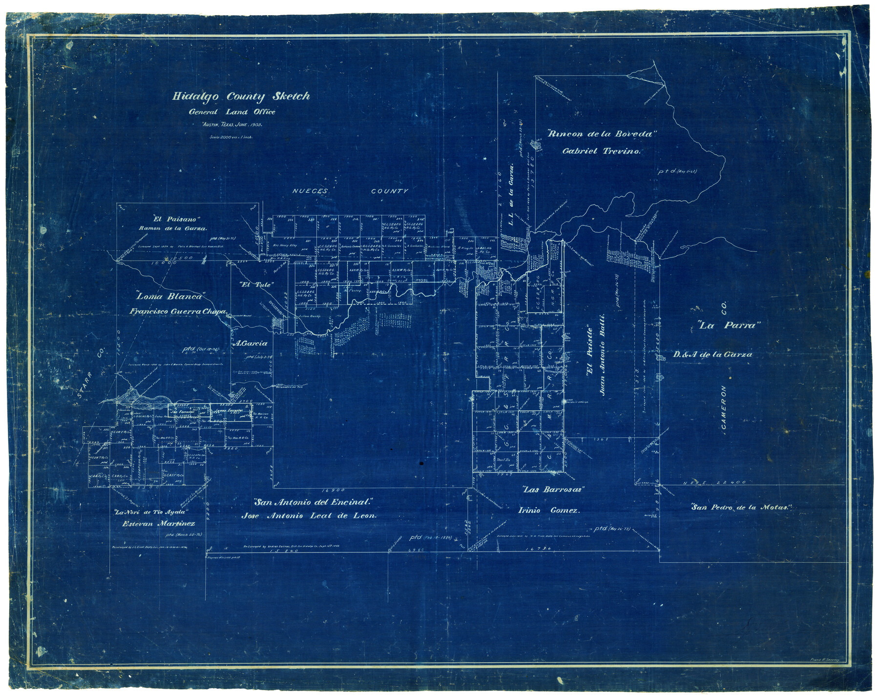
Hidalgo County Sketch
-
Map/Doc
4450
-
Collection
Maddox Collection
-
Object Dates
6/1903 (Creation Date)
-
People and Organizations
Frank R. Sweeney (Draftsman)
-
Counties
Hidalgo Brooks Kenedy Kleberg Jim Wells Nueces Starr Cameron
-
Height x Width
30.4 x 37.7 inches
77.2 x 95.8 cm
-
Medium
blueprint/diazo
-
Scale
1" = 2000 varas
-
Comments
Hand written notation on the back, "Sketch - Hidalgo County. Santa Rosa + Ranch Maps made for D. Sullivan by F. M. Maddox". Also, D. Sullivan's signature.
Map is labeled as Hidalgo County and shows bordering counties as Starr, Nueces and Cameron. -
Features
Los Olmos Creek
Rincon de la Boveda
Passo Ancho
Lindero del Passo Ancho
Purgatorio Hill
El Paisano
Loma Blanca
El Tule
Laguna del Mocho
La Parra
Laguna Lindero
Derramadero del Tule
San Pedro de la Motas
Las Barrosas
San Antonio del Encinal
La Nori de Tio Ayala
Part of: Maddox Collection
Map of Hays County, Texas

Print $20.00
- Digital $50.00
Map of Hays County, Texas
1880
Size 24.3 x 21.4 inches
Map/Doc 5029
Free & Williams Subdivision of the north half of Outlots 56 and 57

Print $20.00
- Digital $50.00
Free & Williams Subdivision of the north half of Outlots 56 and 57
Size 10.9 x 29.5 inches
Map/Doc 475
Revised Sectional Map No. 5 showing land surveys in parts of counties of El Paso, Jeff Davis, Presidio and Brewster, Texas

Print $20.00
- Digital $50.00
Revised Sectional Map No. 5 showing land surveys in parts of counties of El Paso, Jeff Davis, Presidio and Brewster, Texas
Size 19.0 x 23.7 inches
Map/Doc 4476
[Kenney's sketch of the surveys in Dickens and Motley Counties]

Print $20.00
- Digital $50.00
[Kenney's sketch of the surveys in Dickens and Motley Counties]
1905
Size 20.1 x 15.7 inches
Map/Doc 367
Map of survey made for Ingham S. Roberts on Application No. 147, SF-9177 containing 413.78 acres, 4 mi SE of Houston, Harris Co. Texas

Print $20.00
- Digital $50.00
Map of survey made for Ingham S. Roberts on Application No. 147, SF-9177 containing 413.78 acres, 4 mi SE of Houston, Harris Co. Texas
1910
Size 37.3 x 31.0 inches
Map/Doc 373
Nolan County, Texas

Print $20.00
- Digital $50.00
Nolan County, Texas
1870
Size 23.9 x 19.5 inches
Map/Doc 744
[Mary L. Williams or Lydia Glasgow Survey, Bastrop County, Texas]
![572, [Mary L. Williams or Lydia Glasgow Survey, Bastrop County, Texas], Maddox Collection](https://historictexasmaps.com/wmedia_w700/maps/0572-1.tif.jpg)
Print $3.00
- Digital $50.00
[Mary L. Williams or Lydia Glasgow Survey, Bastrop County, Texas]
Size 11.9 x 15.6 inches
Map/Doc 572
Tarrant County, Texas

Print $20.00
- Digital $50.00
Tarrant County, Texas
1870
Size 24.1 x 19.1 inches
Map/Doc 758
Floyd County, Texas

Print $20.00
- Digital $50.00
Floyd County, Texas
1889
Size 24.8 x 19.2 inches
Map/Doc 626
[Sketch of a portion of Hutchinson County, Texas]
![413, [Sketch of a portion of Hutchinson County, Texas], Maddox Collection](https://historictexasmaps.com/wmedia_w700/maps/0413.tif.jpg)
Print $20.00
- Digital $50.00
[Sketch of a portion of Hutchinson County, Texas]
1889
Size 14.9 x 17.3 inches
Map/Doc 413
Sketch of part of the NW part, Hutchinson County

Print $20.00
- Digital $50.00
Sketch of part of the NW part, Hutchinson County
1909
Size 20.9 x 31.2 inches
Map/Doc 75816
Map showing surveys in Blocks 45, 3, R & 5T

Print $20.00
- Digital $50.00
Map showing surveys in Blocks 45, 3, R & 5T
1913
Size 30.2 x 37.5 inches
Map/Doc 496
You may also like
Amistad International Reservoir on Rio Grande 98

Print $20.00
- Digital $50.00
Amistad International Reservoir on Rio Grande 98
1950
Size 28.5 x 40.9 inches
Map/Doc 75529
Kimble County Sketch File 28

Print $20.00
- Digital $50.00
Kimble County Sketch File 28
Size 23.3 x 17.8 inches
Map/Doc 11927
Bowie County Boundary File 72 (23)

Print $10.00
- Digital $50.00
Bowie County Boundary File 72 (23)
Size 13.0 x 8.0 inches
Map/Doc 50694
Working Sketch in Gray, Donley, and Carson Counties, Texas

Print $20.00
- Digital $50.00
Working Sketch in Gray, Donley, and Carson Counties, Texas
1909
Size 22.7 x 27.0 inches
Map/Doc 90779
Freestone County

Print $40.00
- Digital $50.00
Freestone County
1918
Size 48.4 x 41.6 inches
Map/Doc 66830
Ward County Sketch File L

Print $20.00
- Digital $50.00
Ward County Sketch File L
Size 23.8 x 29.6 inches
Map/Doc 12601
Map of the Northern Part of Houston District

Print $20.00
- Digital $50.00
Map of the Northern Part of Houston District
1849
Size 26.4 x 26.7 inches
Map/Doc 3223
[Sketch of San Antonio del Encinal, Hidalgo County, Texas]
![4457, [Sketch of San Antonio del Encinal, Hidalgo County, Texas], Maddox Collection](https://historictexasmaps.com/wmedia_w700/maps/4457-1.tif.jpg)
Print $20.00
- Digital $50.00
[Sketch of San Antonio del Encinal, Hidalgo County, Texas]
Size 12.1 x 27.1 inches
Map/Doc 4457
Map of survey of the 100th Meridian west longitude, extending from the north bank of Red River to the intersection of the Northern Boundary of the Creek or Seminole Country

Print $40.00
- Digital $50.00
Map of survey of the 100th Meridian west longitude, extending from the north bank of Red River to the intersection of the Northern Boundary of the Creek or Seminole Country
Size 113.1 x 11.7 inches
Map/Doc 73565

Shackelford County Boundary File 7b

Print $90.00
- Digital $50.00
Shackelford County Boundary File 7b
Size 7.9 x 10.4 inches
Map/Doc 58692
Refugio County Sketch File 22

Print $20.00
- Digital $50.00
Refugio County Sketch File 22
Size 16.2 x 22.3 inches
Map/Doc 12249