Zapata County Rolled Sketch 12 1/2
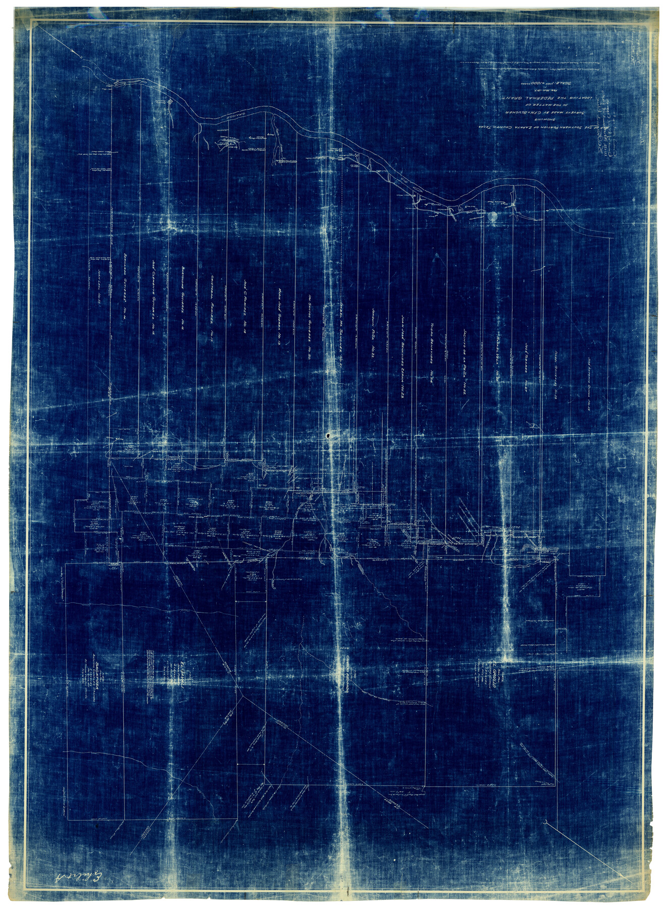
Map of the southern portion of Zapata County, Texas showing surveys made by C.F.H. v. Blucher in the matter of locating the Pedernal grant
-
Map/Doc
10167
-
Collection
General Map Collection
-
Object Dates
3/1917 (Creation Date)
7/20/1938 (File Date)
-
People and Organizations
C.F.H. von Blucher (Surveyor/Engineer)
-
Counties
Zapata
-
Subjects
Surveying Rolled Sketch
-
Height x Width
53.1 x 38.8 inches
134.9 x 98.6 cm
-
Medium
blueprint/diazo
-
Scale
1" = 1000 varas
Part of: General Map Collection
Starr County Rolled Sketch 36

Print $20.00
- Digital $50.00
Starr County Rolled Sketch 36
1947
Size 34.1 x 35.4 inches
Map/Doc 9941
Navigation Maps of Gulf Intracoastal Waterway, Port Arthur to Brownsville, Texas

Print $4.00
- Digital $50.00
Navigation Maps of Gulf Intracoastal Waterway, Port Arthur to Brownsville, Texas
1951
Size 16.6 x 21.3 inches
Map/Doc 65438
Edwards County Sketch File 36

Print $20.00
- Digital $50.00
Edwards County Sketch File 36
Size 18.3 x 18.7 inches
Map/Doc 11436
Hopkins County Sketch File 6

Print $7.00
- Digital $50.00
Hopkins County Sketch File 6
1853
Size 12.4 x 8.1 inches
Map/Doc 26689
Hidalgo County Working Sketch 3

Print $20.00
- Digital $50.00
Hidalgo County Working Sketch 3
1941
Size 41.1 x 32.8 inches
Map/Doc 66180
Lake Corpus Christi and a city map of Mathis, Texas [Verso]
![94171, Lake Corpus Christi and a city map of Mathis, Texas [Verso], General Map Collection](https://historictexasmaps.com/wmedia_w700/maps/94171.tif.jpg)
Lake Corpus Christi and a city map of Mathis, Texas [Verso]
1984
Size 29.3 x 22.9 inches
Map/Doc 94171
Sutton County Boundary File 2a

Print $20.00
- Digital $50.00
Sutton County Boundary File 2a
Size 8.6 x 6.3 inches
Map/Doc 59014
Map of the United States with its territories: also Mexico and the West Indies

Print $20.00
- Digital $50.00
Map of the United States with its territories: also Mexico and the West Indies
1851
Size 40.1 x 36.7 inches
Map/Doc 93925
Harris County Sketch File AA-2

Print $26.00
- Digital $50.00
Harris County Sketch File AA-2
Size 11.3 x 8.5 inches
Map/Doc 25323
Crockett County Rolled Sketch 57

Print $40.00
- Digital $50.00
Crockett County Rolled Sketch 57
1944
Size 52.7 x 28.0 inches
Map/Doc 8719
San Jacinto County Sketch File 22

Print $136.00
San Jacinto County Sketch File 22
1935
Size 11.3 x 8.7 inches
Map/Doc 35734
Tarrant County Sketch File 24

Print $6.00
- Digital $50.00
Tarrant County Sketch File 24
Size 15.3 x 10.0 inches
Map/Doc 37735
You may also like
Coast Chart No. 211 - Padre I. and Laguna Madre Lat. 27° 12' to Lat. 26° 33' Texas

Print $20.00
- Digital $50.00
Coast Chart No. 211 - Padre I. and Laguna Madre Lat. 27° 12' to Lat. 26° 33' Texas
1890
Size 27.2 x 18.2 inches
Map/Doc 72821
Flight Mission No. DQO-11K, Frame 20, Galveston County

Print $20.00
- Digital $50.00
Flight Mission No. DQO-11K, Frame 20, Galveston County
1952
Size 18.8 x 22.4 inches
Map/Doc 85215
Travis County Working Sketch 9

Print $20.00
- Digital $50.00
Travis County Working Sketch 9
1918
Size 21.9 x 28.9 inches
Map/Doc 69393
El Paso County Rolled Sketch 2A

Print $20.00
- Digital $50.00
El Paso County Rolled Sketch 2A
1889
Size 24.1 x 32.8 inches
Map/Doc 5821
Comanche County Sketch File 13

Print $4.00
- Digital $50.00
Comanche County Sketch File 13
Size 8.5 x 8.6 inches
Map/Doc 19076
Dimmit County Sketch File 14

Print $20.00
- Digital $50.00
Dimmit County Sketch File 14
1884
Size 35.7 x 23.3 inches
Map/Doc 11342
Aransas County Sketch File 37

Print $139.00
- Digital $50.00
Aransas County Sketch File 37
1995
Size 11.1 x 9.1 inches
Map/Doc 13413
Brown County Working Sketch 4

Print $20.00
- Digital $50.00
Brown County Working Sketch 4
1926
Size 23.4 x 22.4 inches
Map/Doc 67769
Callahan County Working Sketch Graphic Index

Print $20.00
- Digital $50.00
Callahan County Working Sketch Graphic Index
1969
Size 41.3 x 33.4 inches
Map/Doc 76485
General Highway Map, Navarro County, Texas

Print $20.00
General Highway Map, Navarro County, Texas
1939
Size 24.7 x 18.4 inches
Map/Doc 79206
Tyler County Working Sketch 13

Print $20.00
- Digital $50.00
Tyler County Working Sketch 13
1957
Size 34.5 x 38.5 inches
Map/Doc 69483
