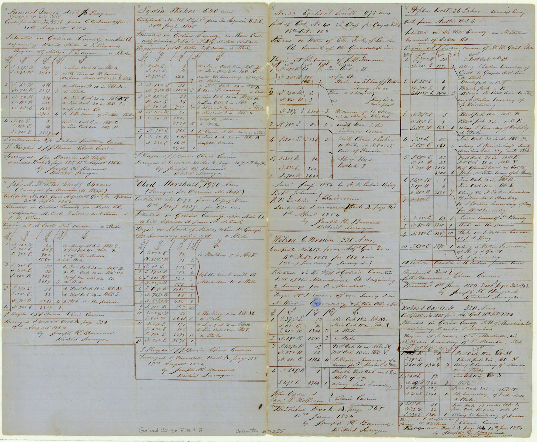
Goliad County Sketch File 18
[List and metes and bounds of many surveys in the county]
-
Map/Doc
24255
-
Collection
General Map Collection
-
Object Dates
1854/6/12 (Creation Date)
1854/10/17 (File Date)
1854/8/15 (Survey Date)
-
People and Organizations
James N. Kinnaird (Chainman)
Joseph H. Barnard (Surveyor/Engineer)
James Hughes (Chainman)
J.J. Burris (Chainman)
Frederick Hart (Chainman)
Robert Johnson (Chainman)
J.P. Erskine (Chainman)
Charles Zettler (Chainman)
W.G. Kelly (Chainman)
D. Day (Chainman)
J.W. Goffett (Chainman)
E.T. Goffett (Chainman)
W. Hughes (Chainman)
J. Simmons (Chainman)
N. Lauderback (Chainman)
A.C. Fairman (Chainman)
J. Bownds (Chainman)
T.W. Uzzell (Chainman)
-
Counties
Goliad DeWitt Karnes
-
Subjects
Surveying Sketch File
-
Height x Width
12.8 x 15.5 inches
32.5 x 39.4 cm
-
Medium
paper, manuscript
-
Features
Perdido River
Little Perdido River
Goat Creek
Cougar Creek
Ojo de Agua Creek
Medio Creek
Elm Fork of Sandie's Creek
Guadalupe River
Northeastern Branch of Coleto Creek
Manahuilla Creek
Cleto [[sic] Creek
Timber Creek
Part of: General Map Collection
Travis County Rolled Sketch 47

Print $40.00
- Digital $50.00
Travis County Rolled Sketch 47
1931
Size 57.2 x 25.4 inches
Map/Doc 10628
San Patricio County Rolled Sketch 42

Print $20.00
- Digital $50.00
San Patricio County Rolled Sketch 42
Size 18.6 x 37.3 inches
Map/Doc 7728
Hood County Sketch File 17

Print $4.00
- Digital $50.00
Hood County Sketch File 17
1860
Size 8.2 x 9.4 inches
Map/Doc 26599
Hill County Sketch File 23

Print $8.00
- Digital $50.00
Hill County Sketch File 23
1862
Size 7.9 x 8.3 inches
Map/Doc 26512
Lavaca County Sketch File 21

Print $40.00
- Digital $50.00
Lavaca County Sketch File 21
1951
Size 60.6 x 39.1 inches
Map/Doc 10520
Garza County Sketch File 2

Print $20.00
- Digital $50.00
Garza County Sketch File 2
Size 33.1 x 30.3 inches
Map/Doc 10462
Hardin County Working Sketch 44

Print $40.00
- Digital $50.00
Hardin County Working Sketch 44
1954
Size 53.2 x 39.9 inches
Map/Doc 65610
Gillespie County Boundary File 6

Print $2.00
- Digital $50.00
Gillespie County Boundary File 6
Size 11.3 x 8.9 inches
Map/Doc 53770
Lampasas County Sketch File A1

Print $2.00
- Digital $50.00
Lampasas County Sketch File A1
Size 6.8 x 6.3 inches
Map/Doc 29385
Galveston County NRC Article 33.136 Sketch 70

Print $24.00
- Digital $50.00
Galveston County NRC Article 33.136 Sketch 70
2012
Size 24.0 x 24.3 inches
Map/Doc 95111
Flight Mission No. DAH-17M, Frame 23, Orange County

Print $20.00
- Digital $50.00
Flight Mission No. DAH-17M, Frame 23, Orange County
1953
Size 18.7 x 22.5 inches
Map/Doc 86886
Flight Mission No. BRA-16M, Frame 165, Jefferson County

Print $20.00
- Digital $50.00
Flight Mission No. BRA-16M, Frame 165, Jefferson County
1953
Size 18.6 x 22.4 inches
Map/Doc 85763
You may also like
[Sketch showing surveys on the north side of the Canadian River, Blocks B-11, L, O-18, and G and M 2 and 3]
![91737, [Sketch showing surveys on the north side of the Canadian River, Blocks B-11, L, O-18, and G and M 2 and 3], Twichell Survey Records](https://historictexasmaps.com/wmedia_w700/maps/91737-1.tif.jpg)
Print $20.00
- Digital $50.00
[Sketch showing surveys on the north side of the Canadian River, Blocks B-11, L, O-18, and G and M 2 and 3]
1883
Size 35.4 x 25.3 inches
Map/Doc 91737
Chocolate Bay, West Portion of West Bay and Vicinity, and Galveston Cos. Showing Subdivision for Mineral Development.

Print $40.00
- Digital $50.00
Chocolate Bay, West Portion of West Bay and Vicinity, and Galveston Cos. Showing Subdivision for Mineral Development.
1948
Size 43.0 x 55.9 inches
Map/Doc 3012
Flight Mission No. CRK-7P, Frame 131, Refugio County

Print $20.00
- Digital $50.00
Flight Mission No. CRK-7P, Frame 131, Refugio County
1956
Size 18.3 x 22.1 inches
Map/Doc 86954
[Galveston, Harrisburg & San Antonio Railroad from Cuero to Stockdale]
![64194, [Galveston, Harrisburg & San Antonio Railroad from Cuero to Stockdale], General Map Collection](https://historictexasmaps.com/wmedia_w700/maps/64194.tif.jpg)
Print $20.00
- Digital $50.00
[Galveston, Harrisburg & San Antonio Railroad from Cuero to Stockdale]
1907
Size 13.6 x 34.0 inches
Map/Doc 64194
Burnet County Working Sketch 7

Print $20.00
- Digital $50.00
Burnet County Working Sketch 7
1960
Size 17.9 x 20.3 inches
Map/Doc 67850
Flight Mission No. CRC-4R, Frame 98, Chambers County

Print $20.00
- Digital $50.00
Flight Mission No. CRC-4R, Frame 98, Chambers County
1956
Size 18.6 x 22.3 inches
Map/Doc 84895
Wichita County Working Sketch 11

Print $20.00
- Digital $50.00
Wichita County Working Sketch 11
1920
Size 32.0 x 18.8 inches
Map/Doc 72520
Jefferson County Working Sketch 30b

Print $20.00
- Digital $50.00
Jefferson County Working Sketch 30b
Size 19.1 x 21.8 inches
Map/Doc 66574
Jefferson County Boundary File 1

Print $10.00
- Digital $50.00
Jefferson County Boundary File 1
Size 9.8 x 6.7 inches
Map/Doc 55514
Hunt County Rolled Sketch 5

Print $20.00
- Digital $50.00
Hunt County Rolled Sketch 5
1966
Size 24.6 x 24.2 inches
Map/Doc 6276
Yoakum County Sketch File 16

Print $20.00
- Digital $50.00
Yoakum County Sketch File 16
1939
Size 15.0 x 19.4 inches
Map/Doc 12709
J. De Cordova's Map of the State of Texas Compiled from the records of the General Land Office of the State

Print $20.00
- Digital $50.00
J. De Cordova's Map of the State of Texas Compiled from the records of the General Land Office of the State
1849
Size 34.0 x 31.5 inches
Map/Doc 656